

1913 Easter tornado outbreak
Severe windstorm in the United States
- 7 min read
- 5 chapters

Related on Lably
Through Great Plains, Yard and NEXRAD
Background
A series of potent storm systems traversed the US during March 1913, described by the US Weather Bureau as "...the most extraordinary situation in regards to the weather since the creation of the bureau." Anomalously high moisture had gathered near the US Gulf Coast, as an intense upper level storm system moved in from the west. According to retrospective numerical modeling of this event, a strong cap aloft was in place over the central Plains, as is common as the elevated mixed layer advects eastward from the Rockies. Observations taken at 13Z 23 March 1913 showed that surface low pressure was located in Colorado, and a warm front stretched due eastward from there into Illinois. Morning temperatures near this front were in the 30s. South of the front warmer and moister air was present, but dewpoints in the upper 50s were confined to southern Oklahoma and Arkansas, far away from where the tornadoes were to later occur in eastern Nebraska and western Iowa.
As the day progressed, the surface low ejected through Nebraska, with a dry line and trailing cold front. South winds blowing 40–50 knots at times brought the moister air rapidly northward. One of the worst dust storms on record occurred behind the dry line in western Kansas, but in the warm sector the day remained dry until mid afternoon when light showers began to form in central Nebraska. A cooperative observer in Osceola noted that the wind shifted from S to NW at 2230Z (4:30 PM local). Professors at the University of Nebraska at Lincoln noted that the relative humidity there jumped from 53% at 2150Z to 78% at 2230Z, indicating much higher dewpoints had rapidly arrived in Lincoln since the cold front was still to the west near Osceola. They also noted that the surface low passed just to the north of Omaha and was in western Iowa at 01Z 24 March 1913.
With all of this observed information, it is likely that the quality moisture required to produce convection strong enough for tornadoes arrived just an hour or two before the strong forcing associated with the surface low pressure and attendant frontal systems. At the time of the tornadoes it is estimated that surface temperatures were in the upper 60s, dewpoints were in the upper 50s, and surface winds were southerly around 25–30 knots. Numerical modeling estimates that 500 hPa flow was around 80 knots from the WSW and that CAPE was from 1000 to 2000 J/kg. These conditions are similar to those found in other tornado outbreaks. Tornadic storms developed from 5:00-6:00 PM local time and while storm motions were to the NE, the prevalence of tornadic storms moved southward with the dryline/cold front intersection, lasting until 8:00 PM local in NW Missouri. A serial derecho then formed and moved across Iowa and Illinois through the nighttime hours, hitting Chicago in the early morning.
Sign in to keep reading
4 more chapters are free with a Lably account.
Outbreak statistics
Confirmed tornadoes
Prior to 1990, there is a likely undercount of tornadoes, particularly E/F0–1, with reports of weaker tornadoes becoming more common as population increased. A sharp increase in the annual average E/F0–1 count by approximately 200 tornadoes was noted upon the implementation of NEXRAD Doppler weather radar in 1990–1991. 1974 marked the first year where significant tornado (E/F2+) counts became homogenous with contemporary values, attributed to the consistent implementation of Fujita scale assessments. Numerous discrepancies on the details of tornadoes in this outbreak exist between sources. The total count of tornadoes and ratings differs from various agencies accordingly. The list below documents information from the most contemporary official sources alongside assessments from tornado historian Thomas P. Grazulis.
March 23 event
Omaha, Nebraska–Beebeetown, Iowa
41°15′N 96°00′W / 41.25°N 96°W
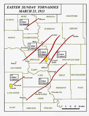
This violent and extremely deadly tornado, the deadliest of the outbreak, would strike Omaha, Nebraska at approximately 6:00 p.m. local standard time on March 23, 1913. The storm's path was reported as being 1⁄4–1⁄2 mi (0.40–0.80 km) wide and contained multiple vortices.
The Omaha tornado followed the path of Little Papillion Creek as it entered the city. It moved through the west side of town alongside the Missouri Pacific Railroad, destroying the small workers cottages in the area. The tornado was so strong that steel train cars were later found pierced by pieces of shattered lumber from the demolished homes.
By the time the tornado reached Dewey Avenue it was five blocks wide. When it reached Farnam Hill, the tornado followed a shallow valley through this upscale neighborhood. The large mansions of Farnam were no match for the winds, and many houses were torn to pieces, along with several in the Gold Coast Historic District including the Joslyn Castle, which sustained considerable damage. Buildings were found chopped in half, pipes and supports dangling into space, such as the Duchesne Academy which was nearly obliterated.
At North 24th and Lake Streets in the Near North Side neighborhood a large African American crowd was enjoying an Easter Sunday performance when the tornado flattened the building and killed more than two dozen people. Other brick structures in this small commercial district took similar hits, and more people died here than in any other part of Omaha. A streetcar running down North 24th Street in North Omaha encountered the tornado near this area. Thanks to the quick action of operator Ord Hensley in ordering passengers to lie on the floor of the car, everyone survived. Later, photographers would spot the wrecked machine and would call it the "Streetcar of Death", imagining that no one on board could have survived given the immense damage.
The F4 tornado skirted the downtown area and moved over the Missouri River into Iowa, killing a few children near Beebeetown and causing further damage. Passing north of Persia, the tornado tracked through or near Defiance, Panama, and Manilla. South of Arcadia it hurled a farmhouse 50 ft (15 m), shortly before dissipating. Tornado expert Thomas P. Grazulis variously estimated a total path length of 40 to 45 mi (64 to 72 km), but subsequent analysis by other researchers in 2007 indicated a path more than twice as long.
In all, 103 people died, 94 of which were in Omaha, and at least 350 were injured. Reportedly, 1,700 homes in Omaha alone were destroyed or damaged, with $8 million total damage from the storm, $51⁄2 million of which was in Omaha (financial damage estimates vary; the NOAA reports more damage than this). In the aftermath of the tornado, a cold front moved into Omaha and caused further misery, as newly homeless residents struggled to escape the snowy weather. Many homes, mostly small, throughout the northern side of the city were leveled, and "dozens" were swept away. Photographs at the time showed empty foundations, suggestive of F5 damage, but these may have been related to post-tornado clean-up.
Non-tornadic effects
The same storm system that struck Nebraska created a dust storm in Kansas and hit Missouri with hail and heavy rain. The Omaha tornado marked the beginning of the destruction from storms associated with the Great Flood of 1913. On Monday and Tuesday, March 24 and 25, the storms brought heavy rains to the Midwest and upstate New York, causing widespread flooding.
Aftermath
Remarkably, operators from the Webster Telephone Exchange Building in Omaha did not leave their stations either during or after the tornado. The building was used as an infirmary for the wounded and dying, with physicians and nurses coming from area hospitals. US Army troops from Fort Omaha set up headquarters in the building, as soldiers patrolled the area for looters and to offer assistance.
Initially, James Dahlman, the longtime mayor of Omaha, refused assistance from any outside sources, including the federal government. However, he relented after seeing the extent of the damage throughout the city. The federal government poured in assistance soon after. The massive damage caused by the tornado inspired new engineering techniques aimed at creating a tornado-proof edifice. The first such building was the First National Bank of Omaha building, built in 1916 at 1603 Farnam Street. The 14-story building was built in a "U"-shape.