


Related on Lably
Through Archipelago
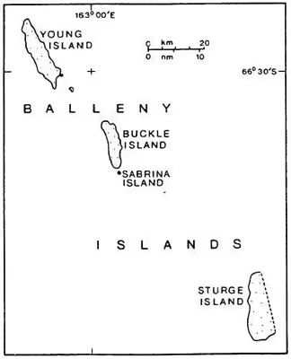
The group includes three main islands: Young, Buckle and Sturge, which lie in a line from northwest to southeast, and several smaller islets and rocks:
- northeast of Young Island: Seal Rocks, Pillar
- southeast of Young Island: Row Island, Borradaile Island (with Swan Base shelter hut)
- south of Buckle Island: Scott Cone, Chinstrap Islet, Sabrina Islet (with Sabrina Refuge shelter hut), and the Monolith
The islands are claimed by New Zealand as part of the Ross Dependency (see Territorial claims in Antarctica).
Islands and rocks from north to south
The islands' area totals 400 km2 (154 mi2) and the highest point has been measured as 1,705 m (5,594 ft) or approximately 1,500 m (5,000 ft) (the unclimbed Brown Peak on Sturge Island).
The Antarctic Circle is close to Borradaile Island, in the eight-kilometre channel between Young and Buckle Islands. Buckle Island and the nearby Sabrina Island is home to several colonies of Adelie and chinstrap penguins.
Sign in to keep reading
4 more chapters are free with a Lably account.
Recorded human visits to the islands
The English sealing captains John Balleny and Thomas Freeman first sighted the group in 1839. Balleny named the island group after himself and the individual islands after the London merchants whose financial backing had made the expedition possible. Freeman was the first person known to land on any of the islands on 9 February 1839, and this was the first recorded human landfall south of the Antarctic Circle.
Sealers sighted the islands in 1853 but did not land.
In 1948, the islands were surveyed by the Australian National Antarctic Research Expeditions aboard HMAS Wyatt Earp. A small landing party led by Stuart Campbell made landfall in a whaleboat on 29 February 1948, apparently the first people to set foot on the islands since their discovery in 1839.
In February 2015 the islands were visited for three days by the New Zealand-Australia Antarctic Ecosystems Voyage under the auspices of the New Zealand National Institute of Water and Atmospheric Research aboard the vessel RV Tangaroa, with the objective of studying marine life ecosystems of the islands, especially with reference to the humpback whale. This work followed up work done on a previous visit in 2010.
On 3 February 2017, personnel from the Swiss Polar Institute's Antarctic Circumnavigation Expedition visited the islands and carried out considerable photographic and video survey work which was intended to contribute to the first accurate mapping of the main islands. Most of the work was done by helicopter, although at least one landfall was also made on the islands by this expedition, using Zodiac inflatable boats.
Geology
In the archipelago, the Buckle, Sturge and Young Islands are examples of stratovolcanoes. Strong earthquakes very close to the islands are rare, but tremors of moderate strength do occur over the Pacific-Antarctic Ridge, Macquarie triple junction and Pacific Rim between the Balleny Islands and Macquarie Island. Other earthquakes occur near the Southeast Indian Ridge and Balleny fracture zone, including a magnitude 8.1 earthquake in 1998 that struck just over 700 km (430 mi) west-northwest of the islands which changed the pattern of seismicity in a wide area around the islands.
It is possible that these islands are still volcanically active. The Brown Peak volcano may have had an eruption in 2001, based on satellite observation.
Weather
The islands experience strong weather with powerful winds and regular gales for much of the year. Cloud cover is present most of the time with an average of only 15 days of blue sky a year.
Submerged features
Several underwater features lie close to the Balleny Islands:
- Balleny Seamounts
- Balleny Trough
- Umitaka Bank
- Vaughan Seamount