

Fly River
River in Papua New Guinea
- 4 min read
- 7 chapters

Related on Lably
Through River delta, Coconut and Sugarcane
Description
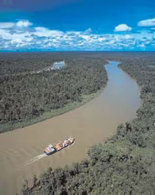
The Fly flows mostly through the Western Province of Papua New Guinea and for a small stretch, it forms the international boundary with Indonesia's western New Guinea. This section protrudes slightly to the west of the 141°E longitude line. To compensate for this gain in territory for Papua New Guinea, the border south of the Fly River is slightly east of the 141°E longitude line. As part of this deal, Indonesia has the right to use the Fly River to its mouth for navigation.
The principal tributaries of the Fly are the Strickland and the Ok Tedi.
Close to its mouth, the flow of the Fly River encounters a tidal bore, where an incoming high tide pushes water upstream until the tide changes. The range of this tidal bore is still undocumented.
Sign in to keep reading
6 more chapters are free with a Lably account.
Discharge
Sediment load:
Tributaries
The main tributaries from the mouth:
Delta
The delta of the Fly River is over 100 km wide at its entrance, but only 11 km wide at the apex upstream of Kiwai Island. The delta contains three main distributary channels (the Southern, Northern, and Far Northern Entrances) that branch from a common point (the “apex”). The distributary channels are 5 to 15 m in depth, separated by elongate, sand-mud islands that are stabilized by lush mangrove vegetation. The islands are eroded and rebuilt rapidly in the apex area, where they have lateral migration rates of up to 150 m/a, with slower rates for the more seaward islands. Upstream from the apex the river gradually narrows to a width of 1.6 km or less. The Fly Delta exhibits a distinctive funnel shape in plan view, attesting to the fundamental role of tidal currents in shaping the Delta's geomorphology. Mean spring tidal ranges are amplified within the delta, from around 3.5 m at the seaward entrance of the distributary channels, reaching a peak of about 5 m at the delta apex. Seismic profiles and radiometrically dated core samples indicate that the delta is prograding seawards at an average rate of about 6 m/a
The Fly Delta is considered a global "type case" of a tide-dominated delta and the patterns of sedimentation seen in the delta today have been studied by sedimentary geologists as a model for interpreting the ancient rock record.
The river delta is studded with low and swampy islands covered with mangroves and nipa palm, with villages and cultivated areas on these islands. The land on both sides of the estuary is of the same character. The islands in the estuary are flat and covered with thick, fertile alluvial soil. The largest islands are Kiwai Island, Purutu Island, Wabuda Island, Aibinio Island, Mibu Island, and Domori Island. Kiwai, Wabuda, and Domori are inhabited.
A list of the river delta islands is:
The inhabitants of the Fly River delta engage in agriculture and hunting. Coconut palm, breadfruit, plantain, sago palm, and sugar cane are grown.
Fly River turtle
The Fly River turtle, also known as the Pig-nosed turtle due to its odd nose, is notably different from other turtles because of its pig-like nose. The only freshwater turtle to have flippers, the turtle is known to rarely leave water, except in dire circumstances. They are also known to be omnivores that rarely eat meat.
History
The Fly was first discovered by Europeans in 1845 when Francis Blackwood, commanding the corvette HMS Fly, surveyed the western coast of the Gulf of Papua. The river was named after his ship and he proclaimed that it would be possible for a small steam-powered boat to travel up the mighty river.
In 1876, Italian explorer, Luigi D'Albertis, was the first person to successfully attempt this when he travelled 900 km into the interior of New Guinea, in his steamer, Neva. It was the furthest any European explorer had ever been into the island.
Environmental issues
Both the Strickland and the Ok Tedi Rivers have been the source of environmental controversy due to tailings waste from the Porgera Mine and the Ok Tedi Mine, respectively. Sediment sampling and coring in the distributary channels of the Fly Delta had not detected copper concentrations significantly higher than background as of 1994. In 2008, Ian Campbell, a former advisor to Ok Tedi Mining Limited, claimed that company data suggest significant portions of the Fly River floodplain are at a high risk from acid mine drainage.