

Karakoram
Mountain range spanning the borders between Pakistan, India and China
- 6 min read
- 7 chapters

Learn it on Lably
The Karakoram begins in the Wakhan Corridor in eastern Afghanistan and extends eastwards into Indian-administered Ladakh and Chinese-administered Aksai Chin, as well as the Chinese province of Xinjiang. Most of the Karakoram is located within the Pakistani-administered Gilgit-Baltistan region. The Karakoram is bounded on the east by the Aksai Chin plateau, on the north-east by the edge of the Tibetan Plateau, and on the north by the river valleys of the Yarkand and Karakash rivers, beyond which lie the Kunlun Mountains. At the north-west corner are the Pamir Mountains, while to the west lies Hindu Kush. The southern boundary of the Karakoram is formed west to east by the Gilgit, Indus, and Shyok rivers, which separate the range from the north-western end of the Himalaya. These rivers flow north-west before making an abrupt turn south-westwards towards the plains of Pakistan. Roughly in the middle of the Karakoram range is the Karakoram Pass, which was part of a now unused trade route between Ladakh and Yarkand.
The Karakoram lies north of the Kashmir Valley and forms part of the wider mountain system surrounding the valley, together with the Pir Panjal and Zanskar ranges.
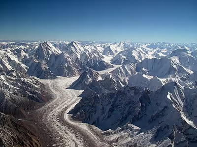
The range is about 500 km (311 mi) in length and is the most glaciated place on Earth outside the polar regions. The Siachen Glacier (76 km (47 mi) long) and Biafo Glacier (63 km (39 mi) long) are the second- and third-longest glaciers outside the polar regions. The Karakoram is the second-highest mountain range on Earth and part of a complex of ranges that includes the Pamir Mountains, Hindu Kush, and the Himalayas. The range contains eighteen summits higher than 7,500 m (24,600 ft) in elevation, with four above 8,000 m (26,000 ft) which include K2, Gasherbrum I, Broad Peak, and Gasherbrum II.
Name
Karakoram is a Turkic term meaning black gravel. The Central Asian traders originally applied the name to the Karakoram Pass. Early European travelers, including William Moorcroft and George Hayward, started using the term for the range of mountains west of the pass, although they also used the term Muztagh (meaning, "Ice Mountain"). Thomas Montgomerie of the Survey of India labelled its high peaks K1 to K6 ("K" for Karakoram), identifying them from his station at Mount Haramukh in the 1850s.
In the Sanskrit literature (the Puranas), the Karakoram mountains were called Krishnagiri (black mountains), with vernacular variations of Kanhagiri and Kanheri.
Sign in to keep reading
6 more chapters are free with a Lably account.
Exploration
Due to its altitude and ruggedness, the Karakoram is much less inhabited than parts of the Himalayas further east. European explorers first visited in the early 19th century, followed by British surveyors starting in 1856.
The Muztagh Pass was crossed in 1887 by the expedition of Colonel Francis Younghusband, and the valleys above the Hunza River were explored by General Sir George K. Cockerill in 1892. Explorations in the 1910s and 1920s established most of the geography of the region.
The name Karakoram was used in the early 20th century, for example by Kenneth Mason, for the range now known as the Baltoro Muztagh. The term is now used to refer to the entire range from the Batura Muztagh above Hunza in the west to the Saser Muztagh in the bend of the Shyok River in the east.
Floral surveys were carried out in the Shyok River catchment and from Panamik to Turtuk village by Chandra Prakash Kala during 1999 and 2000.
Geology and glaciers
The Karakoram is in one of the world's most geologically active areas, at the plate boundary between the Indo-Australian plate and the Eurasian plate. A significant part, somewhere between 28 and 50 percent, of the Karakoram Range is glaciated, covering an area of more than 15,000 square kilometres or 5,800 square miles, compared to between 8 and 12 percent of the Himalaya and 2.2 percent of the Alps. Mountain glaciers may serve as an indicator of climate change, advancing and receding with long-term changes in temperature and precipitation. The Karakoram glaciers are slightly retreating, unlike the Himalayas, where glaciers are losing mass at a significantly higher rate, many Karakoram glaciers are covered in a layer of rubble which insulates the ice from the warmth of the sun. Where there is no such insulation, the rate of retreat is high. Some recent studies reveal slight increase or stability in glacier mass in central and western Karakoram, termed by some scholars as "Karakoram Anomaly", contrasting with eastern Karakoram where glaciers were found to be retreating. Notable glaciers in Karakoram include:
- Siachen Glacier
- Baltoro Glacier
- Hispar Glacier
- Batura Glacier
- Biafo Glacier
- Chogo Lungma Glacier
- Yinsugaiti Glacier
Ice Age
In the last ice age, a connected series of glaciers stretched from western Tibet to Nanga Parbat, and from the Tarim Basin to the Gilgit District. To the south, the Indus glacier was the main valley glacier, which flowed 120 kilometres (75 mi) down from the Nanga Parbat massif to 870 metres (2,850 ft) elevation. In the north, the Karakoram glaciers joined those from the Kunlun Mountains and flowed down to 2,000 metres (6,600 ft) in the Tarim Basin.
While the current valley glaciers in the Karakoram reach a maximum length of 76 kilometres (47 mi), several of the ice-age valley glacier branches and main valley glaciers, had lengths up to 700 kilometres (430 mi). During the Ice Age, the glacier snowline was about 1,300 metres (4,300 ft) lower than today.
Highest peaks
The majority of the highest peaks are in the Gilgit–Baltistan region administered by Pakistan. Baltistan has more than 100 mountain peaks exceeding 6,100 metres (20,000 ft) height from sea level. Following is a list of the highest peaks of the Karakoram. Included are some of the mountains named with a K code, the most well-known of which is K2.
Subranges
The naming and division of the various subranges of the Karakoram is not universally agreed upon. However, the following is a list of the most important subranges, following Jerzy Wala. The ranges are listed roughly west to east.
- Batura Muztagh
- Rakaposhi-Haramosh Mountains
- Spantik-Sosbun Mountains
- Hispar Muztagh
- South Ghujerab Mountains
- Panmah Muztagh
- Wesm Mountains
- Masherbrum Mountains
- Baltoro Muztagh
- Saltoro Mountains
- Siachen Muztagh
- Rimo Muztagh
- Saser Muztagh
Passes
Passes from west to east are:
- Dandala Pass is the most important and earlier pass. It starts from Ghursay saitang city to Yarqand in China. It is the main trade route between Khaplu, Ladakh, Kharmang to Yarqand, China.
- Kilik Pass
- Mintaka Pass
- Khunjerab Pass is the highest paved international border crossing at 4,693 m (15,397 ft). It serves the China-Pakistan Friendship Highway, the "8th world wonder".
- Shimshal Pass
- Mustagh Pass
- Karakoram Pass
- Sasser Pass
- Naltar Pass
The Khunjerab Pass is the only motorable pass across the range. The Shimshal Pass (which does not cross an international border) is the only other pass still in regular use.
Cultural references
The Karakoram mountain range has been referred to in a number of novels and movies. Rudyard Kipling refers to the Karakoram mountain range in his novel Kim, which was first published in 1900. Marcel Ichac made a film titled Karakoram, chronicling a French expedition to the range in 1936. The film won the Silver Lion at the Venice Film Festival of 1937. Greg Mortenson details the Karakoram, and specifically K2 and the Balti, extensively in his book Three Cups of Tea, about his quest to build schools for children in the region. K2 Kahani (The K2 Story) by Mustansar Hussain Tarar describes his experiences at K2 base camp.