

Lake Taymyr
Lake in Krasnoyarsk Krai, Russia
- 1 min read
- 3 chapters

Related on Lably
Through Lake, Russia and Overexploitation
Geography
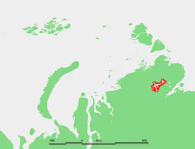
Lake Taymyr is approximately 165 km (103 mi) roughly east-to-west. It has an irregular shape with many arms projecting in different directions that cover a wide region. Its maximum width, however, is only about 23 km (14 mi) in its broadest area, towards the lake's eastern end.
Lake Taymyr is covered with ice from late September until June. The main river flowing into its basin, from the west, is the Upper Taymyra. Other rivers flowing into it are the Zapadnaya, Severnaya, Bikada-Nguoma, Yamu-Tarida and Kalamissamo. The Lower Taymyra flows out of the lake northwards across the Byrranga mountain region.
The tundra areas south of Lake Taymyr are full of smaller lakes and marshes. There are two quite large lakes east and southeast of the easternmost part of Lake Taymyr, Yamuneru Bay: 33 km (21 mi) east is Lake Kungusalakh, and 72 km (45 mi) southeast is Lake Portnyagino. Both lakes are about 20 km (12 mi) across.
Sign in to keep reading
2 more chapters are free with a Lably account.
Ecology
Lake Taymyr is teeming with many kinds of fish typical of cold Arctic waters, such as loach, common whitefish, and muksun. Salvelinus taimyricus, is a char species found in the lake. There is overexploitation of some fish species despite the remoteness of the area.
Slight plutonium contamination has been detected in the sediments of Lake Taymyr. This is perhaps a consequence of wind-carried particles after the numerous atmospheric nuclear tests in Novaya Zemlya during the Cold War.
Water temperatures
- Average water temperature in August: +7 °C (45 °F)
- During winter, water temperature is slightly above +1 °C (34 °F)