


Related on Lably
Through Rock (geology) and Stratum
Characteristics
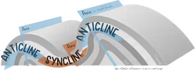
On a geologic map, synclines are recognized as a sequence of rock layers, with the youngest at the fold's center or hinge and with a reverse sequence of the same rock layers on the opposite side of the hinge. If the fold pattern is circular or elongate, the structure is a basin. Folds typically form during crustal deformation as the result of compression that accompanies orogenic mountain building.
Sign in to keep reading
One more chapter is free with a Lably account.
Notable examples
- Powder River Basin, Wyoming, US
- Sideling Hill roadcut along Interstate 68 in western Maryland, US, where the Rockwell Formation and overlying Purslane Sandstone are exposed
- Forêt de Saou syncline in Saou, France
- Southland Syncline in the southeastern corner of the South Island of New Zealand, including The Catlins and the Hokonui Hills
- Strathmore Syncline, Scotland
- Wilpena Pound, Flinders Ranges, South Australia
- Fort Valley, Shenandoah County, Virginia
- Hondo Syncline in the Picuris Mountains of New Mexico, an example of an overturned syncline
- Afikpo syncline, Nigeria
- Table Mountain, South Africa
- Fairfield Basin, New South Wales, Australia