

Tornado outbreak sequence of May 25 – June 1, 1917
1917 extreme weather event in US Southeast and Midwest
- 4 min read
- 4 chapters

Related on Lably
Through Tornado and Kilometres per hour
Meteorological synopsis
A series of low-pressure areas affected the Central and Eastern United States between May 25 and June 1, 1917. The first of these developed by May 25 east of the Rocky Mountains in eastern Colorado. By 7:00 p.m. CST/0100 UTC that day, it intensified to 29.45 inches of mercury (997.3 mb) with temperatures rising at or above 70 °F (21.1 °C) over most of Kansas. The next day, the low-pressure system deepened further into the morning, eventually centering near Yankton, South Dakota, about 7 a.m. CST/1300 UTC. Upon weakening to about 29.55 inHg (1,000.7 mb) in the evening and centering near Des Moines, Iowa, the low was followed by another surface low which formed over the Texas Panhandle and moved northeast. This second low passed near Oklahoma City, Oklahoma, on the morning of May 27 and approached the St. Louis, Missouri, area in the evening. On May 30, yet another low of about 29.5 inHg (999.0 mb) by 7 p.m. CST/0100 UTC moved northeast from near Concordia, Kansas, to Des Moines.
Sign in to keep reading
3 more chapters are free with a Lably account.
List of tornadoes
These numbers are likely gross underestimates. Several of the long-track events listed below are likely to be tornado families, or groups of tornadoes produced by the same storm. Because of insufficient documentation, and lack of a proper storm survey by meteorologists, it is impossible to determine where one tornado ends and another begins in certain cases. Additionally, the book by Grazulis which details the tornadoes of this event only documents "significant" tornadoes, that is, tornadoes which caused fatalities or F2 or greater damage on the Fujita scale. On average, almost 70% of tornadoes are not "significant".
May 25 event
May 26 event
May 27 event
May 28 event
May 30 event
May 31 event
June 1 event
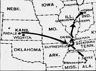
Mattoon/Charleston, Illinois
This devastating and long-tracked tornado event first began before noon CST in eastern Missouri, where significant hail was reported, then crossed the Mississippi River into Illinois near Pleasant Hill. These two towns were probably hit by two separate, weak tornadoes which formed from the same thunderstorm, but intense tornado damage only began 2 miles (3.2 km) east of Nebo, Illinois. From there, moving east at about 40 miles per hour (64 km/h), the first violent member of the event moved into White Hall, hitting farms and injuring six people before weakening and dissipating. Another tornado probably developed over Modesto, 22 miles (35 km) to the east. In Modesto, the tornado destroyed 30 homes and damaged 35 others, with three deaths, 16 injuries, and $120,000 damage reported. Over the next 50 miles (80 km), the tornado either weakened or lifted before touching down again at Dunkel, destroying many homes and barns, and continuing into Westervelt. It destroyed 10 homes and killed four people in Westervelt, but much of the damage was due to hail. Rural areas between Dunkel and Westervelt reportedly received severe damage and reported one death.
After hitting Westervelt, the tornado weakened and probably lifted before reforming and re-intensifying over southern Moultrie County. The new tornado then passed directly through the northern half of Mattoon, causing F4 damage and "near-total destruction" in its path. It destroyed 496 homes, damaged 284, and killed at least 53 people in Mattoon; in the hardest-hit areas, few walls were left standing and only small debris remained. Total damage in Mattoon reached $1.2 million. Between Mattoon and Charleston, a distance of 11 miles (18 km), all farms registered damage and often lost buildings. Entering Charleston, the tornado produced less severe damage than in Mattoon, perhaps due to better construction, but at least 220 homes were still destroyed, 265 badly damaged, 38 people killed, and $780,000 damage caused. The tornado then continued beyond Charleston, causing two final deaths at Embarrass before lifting, though weather officials in 1917 believed that the tornado had continued into Indiana.
At one time, this series of tornadoes was considered a single tornado. Lasting seven hours and 40 minutes and covering 293-mile (472 km), it is now generally believed to have been a family of at least four, and possibly eight or more, distinct tornadoes, with either short breaks in the damage path or sections of straight-line wind damage connecting the tornado paths. Debris such as mail, wallpaper, and parts of books was carried 70 miles (110 km) northeast of the parent supercell. In 1917, the tornado was also believed to have produced winds up to 400 miles per hour (640 km/h), though more recent studies have determined that tornadoes only produce winds up to about 300 miles per hour (480 km/h).