

Yablonovy Mountains
Mountain range in Russia and Mongolia
- 2 min read
- 2 chapters

Related on Lably
Several major cities and strategic settlements are situated along this mountain system:
In Mongolia: The capital city, Ulaanbaatar, lies at the southwestern edge of the range near the Bogd Khan Mountain. Along the southern foothills is Chinggis City, while the western branches of the system house the industrial and transit hubs of Züünkharaa and Sükhbaatar.
In Russia: The city of Chita is the primary urban center, situated between the Yablonovy Mountains to the west and the Chersky Range to the east. The historical border town of Kyakhta is located on the northwestern slopes, and the industrial city of Petrovsk-Zabaykalsky lies within the range's mountain valleys. The Trans-Siberian Railroad passes the mountains at Chita and runs parallel to the range before going through a tunnel to bypass the heights.
Geography
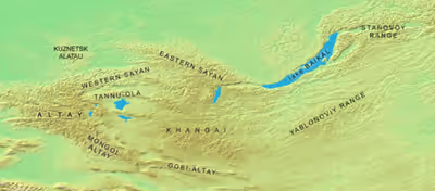
The Yablonovy Mountains stretch for about 650 kilometres (400 mi) in a northeast–southwest direction. They rise mostly in the western part of the Zabaikalsky Krai, with a small section in the southeastern part of Buryatia. The width of the range varies between 20 kilometres (12 mi) and 120 kilometres (75 mi). The Vitim Plateau lies to the north and the Borshchovochny Range to the east of the range. The tallest peak is Kontalaksky Golets, a "golets"-type of mountain with a bald peak, at 1,706 metres (5,597 ft) above sea level.
Its southwestern continuation is the Khentei-Daur Highlands.
The Vitim River flows at the northwestern edge of the range, together with its tributaries the Konda and the Karenga, which flow northeastwards. To the southwest flow the Khilok and the Ingoda and in the northeast the Olyokma.
Sign in to keep reading
One more chapter is free with a Lably account.
Flora
The slopes of the Yablonoviy Range are covered with larch and occasional fir and silver fir taiga. Pine forests are quite common on the southern slopes of the range. Peaks higher than 1,200–1,400 metres are covered with mountain tundra with bare summits (golets) at higher altitudes.