

2002 Veterans Day weekend tornado outbreak
Severe weather event in the eastern United States
- 7 min read
- 2 chapters

Related on Lably
Through Great Plains
Meteorological synopsis
November 9
The first signs for organized severe weather became apparent on November 7, when the Storm Prediction Center (SPC) outlined a Slight risk across portions of the mid-Mississippi and western Ohio River valleys valid for November 9. On that day, a powerful and negatively-tilted upper-level trough upwards of 150 kn (175 mph; 280 km/h) was observed driving east-southeastward toward the U.S. Central and Southern Plains. While a shortwave trough at the leading edge of this feature progressed across the Texas Panhandle, a surface area of low pressure resided across the Central and Northern Plains. Southerly flow associated with the cyclone prompted the northward advection of moisture from the Gulf of Mexico, with dewpoints rising into the lower 60s °F as far north as southern Illinois; this moisture promoted modest destabilization and mid-level convective available potential energy (CAPE) values from 500 to 1,000 J/kg. As the shortwave trough continued eastward, it aided in the formation of thunderstorms across northeastern Arkansas around 00:00 UTC. These storms resided in a strongly sheared environment, with storm relative helicity – a measure of the potential for cyclonic updrafts – around 800 m2/s2. Despite initial concern that the lower levels of the atmosphere were not quite as favorable, evening atmospheric soundings from Little Rock, Arkansas, and Memphis, Tennessee, showcased an extremely favorable environment for significant tornadoes. Clusters of supercells tracked from Arkansas into Tennessee over ensuing hours, and in fact, the persistence of these storms resulted in the formation of a weak outflow boundary that further enhanced the tornado threat. A total of 10 tornadoes occurred throughout the evening of November 9, including multiple strong tornadoes and one that killed two people near Huntingdon, Tennessee.
November 10–11
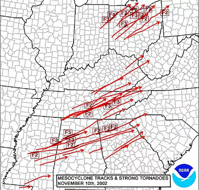
On November 10, the SPC warned of the potential for a significant tornado outbreak and/or widespread damaging wind episode across northeastern Mississippi, much of Tennessee, northwestern Alabama, and much of Kentucky, where the organization issued a High risk of severe weather. Morning upper-air analyses showed mid- to upper-level winds of 100–150 kn (115–175 mph; 185–280 km/h) across the southern Rocky Mountains, as well as an embedded shortwave trough moving east toward the Mississippi and Ohio River valleys. At the surface, a strong area of low pressure was positioned over Wisconsin and moving northeastward toward Ontario. Throughout the afternoon hours, the tornado outbreak unfolded in three distinct locations. To the north across Indiana and Ohio, temperatures rose into the lower 70s and dewpoints climbed into the mid-60s °F, supporting CAPE values of 1,000–2,000 J/kg. In addition, significant pressure falls in the region contributed to backed surface winds, aiding in favorable low-level shear profiles. Although storms in this region were initially congealed into a squall line ahead of a cold front, the presence of strong shear and dry air in the mid-levels supported the line's breakdown into supercells and bowing segments. Ahead of this activity, additional discrete supercells overspread much of Ohio owing to a prefrontal trough. A long-tracked, violent F4 tornado began in Van Wert and tracked for over 52 mi (84 km), killing 4 people and injuring 17 others. An F3 tornado near Tiffin killed one person and injured two others. An F2 tornado in Clark, Pennsylvania, killed 1 person. Numerous other tornadoes were recorded throughout the afternoon. The event evolved into more of a significant damaging wind episode as storms progressed farther east into Pennsylvania by the evening hours.
With the northern outbreak unfolding, a central outbreak simultaneously overspread portions of Tennessee and Kentucky, while a southern outbreak spanned areas from Mississippi into South Carolina. Surface observations and atmospheric soundings across the High and Moderate risk areas showed a very unstable environment with surface-based CAPE values in the 2,000–3,000 J/kg range. Despite the presence of a cap, this inversion was weak and expected to be eroded by warming daytime temperatures. Meanwhile, deep-layer wind shear of 50–60 kn (60–70 mph; 95–110 km/h) overspread the area. Though shear profiles were largely unidirectional initially, low-level winds were expected to become more conducive for discrete supercells and tornadoes. As expected, temperatures climbing to around 80 °F (27 °C) and dewpoints reaching the mid-60s °F allowed for deep convective development into the afternoon. Multiple swaths of supercells developed throughout the region, including one in middle Tennessee, a second from central Mississippi into northwestern Alabama, and a third from northeastern Louisiana into central Mississippi. Fatal tornadoes occurred near Shelbyville, Joyner, and Crossville in Tennessee; Carbon Hill, Saragossa, and Centre in Alabama; and Crawford in Mississippi. Numerous other tornadoes were documented throughout the area. Much like the outbreak farther north, the event transitioned into more of a damaging wind event by the evening hours, though a few tornadoes still occurred during the early morning hours across Georgia and South Carolina.
Sign in to keep reading
One more chapter is free with a Lably account.
Confirmed tornadoes
November 9 event
November 10 event
November 11 event
Van Wert–Roselms, Ohio
On November 10, a violent tornado struck the city of Van Wert and the community of Roselms in Ohio. The National Weather Service rated the worst of the damage F4 on the Fujita scale, with several homes and businesses sustaining F4 damage in the city of Van Wert. The tornado touched down approximately four miles (6.4 km) northeast of the village of Willshire, Ohio in Van Wert County and began moving northeast towards the city of Van Wert. Right after touching down, the tornado rapidly intensified to F4 intensity as it crossed Zook Road approximately five miles (8.0 km) southwest of Van Wert. Around Zook Road, a 75-year-old man was killed when the tornado destroyed his house at F4 intensity. The National Weather Service documented that he was attempting to shield his wheelchair-using wife when the tornado struck. As the tornado continued into Van Wert, it maintained F4 intensity. In Van Wert, 43 homes and five businesses were destroyed and 164 homes and 27 businesses were damaged. The Twin Cinemas and the five buildings in the Vision Industrial Park sustained F4 damage. In the Twin Cinemas, 60 people, mostly children, were inside watching a movie when the tornado destroyed the building. Vehicles from the cinema parking lot were thrown into the seats of the cinema. An 18-year-old was killed after driving near the cinema and having his car thrown into the cinema seats. Three county engineering buildings were also destroyed by the tornado in Van Wert. After passing through the Vision Industrial Park, several homes and business in Van Wert sustained F3 to F4 damage.
The tornado continued northeast out of Van Wert and crossed into Paulding County, where it struck the community of Roselms. Only one building remained standing in Roselms after the tornado. Every structure in Roselms sustained up to F3 damage, and the entire nine-mile (14 km) track of the tornado through Paulding County was rated F3 by the National Weather Service. The Dayton Daily Newspaper reported that in Paulding County, 23 homes, 32 barns, and a church were completely leveled and 19 additional homes were damaged. The Washington Township building was also leveled by the tornado. The tornado continued northeast at F3 intensity as it crossed into Putnam County. In Putnam County, the tornado destroyed a mobile home in Continental, killing a man and his wife. After traveling seven miles (11 km) through the county, the tornado rapidly weakened to F0 intensity just before it crossed into Defiance County. While traveling three miles (4.8 km) through Defiance County, the tornado skipped and caused F0 damage to five homes and some outbuildings before crossing into Henry County. In Henry County, the tornado continued to skip and caused F0 damage to outbuildings and trees along a path of 12 miles (19 km). The tornado lifted approximately two miles (3.2 km) southeast of Malinta.
In total, the tornado killed four people and injured 17 others along a path of 53 miles (85 km), while reaching a peak width of 880 yards (800 m). The tornado caused at least $30 million (2002 USD) in damage just in the city of Van Wert.
The National Oceanic and Atmospheric Administration later stated that out of the entire tornado outbreak, which included a total of 76 tornadoes, the Van Wert–Roselms tornado was the most remembered, due to "the heroic efforts of [Scott Shaffer] at the Van Wert Cinemas. After hearing the tornado warning that was broadcast over the county's warning system, the manager led 60 patrons to interior hallways and restrooms. This was only a few minutes before the tornado destroyed the theater. Besides leveling the building, 3 cars were tossed into the seats that were previously occupied by moviegoers, many of which were children."