

Babuyan Islands
Island group in the Philippines
- 3 min read
- 4 chapters

Related on Lably
Geography
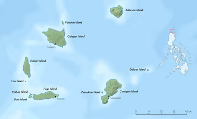
The archipelago, comprising 24 volcanic-coralline islands, has a total area of about 590 km2 (230 sq mi). The largest of these is Calayan with an area of 196 km2 (76 sq mi), while the highest peak in the island group is Mount Pangasun (1,108 metres, 3,635 ft) on Babuyan Claro.
Islands
The table below shows the islands of Babuyan and their adjoining islets and rocks, along with land areas and highest elevation:
Geology
The eastern islands of the archipelago are part of the Luzon Volcanic Arc. Three volcanoes from two of the islands have erupted in historical times - Camiguin de Babuyanes on Camiguin Island, Babuyan Claro Volcano and Smith Volcano (also known as Mount Babuyan) on Babuyan Island.
Another small volcanic island located just 22 km (14 mi) NE of Camiguin Island, Didicas Volcano on Didicas Island, became a permanent island only after emerging and rising to over 200 metres (656 ft) above sea level in 1952.
Sign in to keep reading
3 more chapters are free with a Lably account.
Flora and fauna
All of the islands within the island group are classified by the Haribon Foundation and BirdLife International as key biodiversity areas, or sites with outstanding universal value due to their geographic and biological importance. All of the islands within the island group have never been part of any large landmass, and thus have unique flora and fauna, most of which are found nowhere else. Research conducted by the Department of Environment and Natural Resources has found at least five faunal regions in the area, one of the highest densities of separate faunal regions in the world.
The islands are also home to the most critically endangered snake species in the Philippines, the Ross' wolf snake (found only on the small island of Dalupiri), and the most critically endangered bird species in the Philippines, the Calayan rail (found only on the small island of Calayan). The Babuyan archipelago, along with the nearby Batanes islands, have been designated an Important Bird Area (IBA) by BirdLife International because they support significant populations of resident Taiwan green pigeons, Ryukyu scops-owls and short-crested monarchs, Chinese egrets on passage, and wintering yellow buntings.
The island group is also one of the few congregation sites for endangered humpback whales in Southeast Asia. Due to its value to the natural world and Philippine biological diversity, various scientific and conservation groups have been lobbying for its declaration as a national park and its inclusion in the UNESCO World Heritage List. Humpback whales have re-colonized the area and the Babuyan Group of Islands has become the only wintering ground for the species in the Philippines although historical records from the Babuyan Islands have not been confirmed.
Demographics
List of islands by population (as of 2020):
- Calayan Island - 9,648
- Camiguin Island - 5,231
- Fuga Island - 1,939
- Babuyan Island - 1,910
- Dalupiri Island - 621
- Barit Island - 14
Government
The whole archipelago is administered under the province of Cagayan, with Babuyan, Calayan, Camiguin, and Dalupiri comprising the municipality of Calayan while Fuga is under the jurisdiction of Aparri.
Babuyan and Dalupiri are themselves individual barangays in Calayan municipality, respectively named Babuyan Claro and Dalupiri, while Fuga Island is also an individual barangay, also named Fuga Island, in Aparri.