

Kuril–Kamchatka Trench
Oceanic trench in the northwest Pacific
- 1 min read
- 3 chapters

Related on Lably
Through Volcanism and Approximation
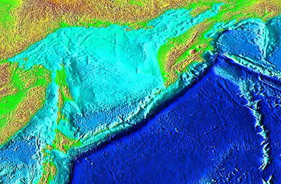
The trench formed as a result of the subduction zone, which formed in the late Cretaceous, that created the Kuril island arc as well as the Kamchatka volcanic arc. The Pacific plate is being subducted beneath the Okhotsk plate along the trench, resulting in intense volcanism.
The maximum depth of the trench is reported in peer-reviewed academic papers as 9,600 meters.
History
The trench was first discovered during an oceanographic and hydrographic survey by the USS Tuscarora, where the ship had detected a depth of 4655 fathoms or 8513 meters in 1874. Due to this recording the trench held the record of the deepest point in the world, beating out the Challenger expedition's recorded depth of 3875 fathoms or 7086 meters in the Mariana Trench, until it was overthrown in the following year by the Mariana Trench which it had just surpassed.
Sign in to keep reading
2 more chapters are free with a Lably account.
Tectonics
At the Kuril–Kamchatka Trench, the Pacific plate is subducting beneath the Okhotsk plate, a minor tectonic plate formerly considered to be part of the North American plate. The convergence rate ranges from ≈75 mm (3.0 in)/yr in the north to ≈83 mm (3.3 in)/yr at the southern end. Obliquity of convergence increases to the south, where the transpressional stress is partitioned into trench-normal thrust earthquakes and trench-parallel strike-slip earthquakes. This partitioning results in westward translation of the Kurile forearc relative to the North American plate.
Associated seismicity
Major earthquakes associated with the subduction zone: