

Prince of Wales Island (Nunavut)
Uninhabited in the Arctic Archipelago
- 1 min read
- 3 chapters

Related on Lably
Through Tundra and Queen Victoria
Geography
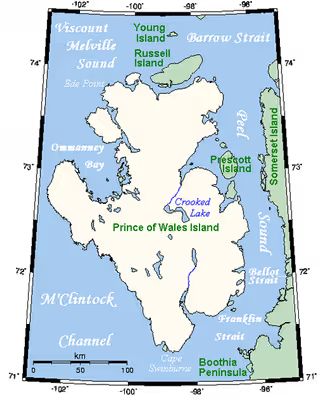
It is a low tundra-covered island with an irregular coastline deeply indented by Ommanney Bay in the west and Browne Bay in the east. Ommanney Bay is named after Admiral Sir Erasmus Ommanney of the Royal Navy who explored the area as part of the search for Franklin's lost expedition. Its area has been estimated at 33,307.98 km2 (12,860.28 sq mi). Prince of Wales Island is the world's 40th largest island and the 10th largest in Canada. Its highest known point—with an elevation of 424 m (1,391 ft)—is an unnamed spot at 73°48′26″N 97°50′14″W / 73.80722°N 97.83722°W in the island's far northeastern end, overlooking the Baring Channel, which separates the island from nearby Russell Island.
Sign in to keep reading
2 more chapters are free with a Lably account.
History
Its European discovery came in 1851 by Leopold McClintock's sledge parties during the searches for John Franklin's last expedition. McClintock, along with Sherard Osborn and William Browne, charted the northern half of the island. Its southern half was charted by Allen Young in 1859. It was named after Albert Edward, eldest son of Queen Victoria, then ten years old and Prince of Wales. He later became King Edward VII.
In popular culture
The CBC series North of North is set in the fictional town of Ice Cove, which is situated on Prince of Wales Island.