

Severe weather sequence of July 13–16, 2024
Wind, tornado, and flooding event in the United States
- 8 min read
- 5 chapters

Related on Lably
Through Tornado
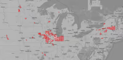
The sequence began as a line of supercells and evolved into a powerful mesoscale convective system over Montana late on July 13, which raced southeasterly into North Dakota, South Dakota, and Nebraska while producing widespread wind gusts of over 60 mph (97 km/h) and as high as 108 mph (174 km/h) into the overnight hours of July 14. Further east in Illinois and Indiana, a system on the morning of July 14 brought rainfall up to 6.3 in (16 cm) to Rockford, Illinois, which caused flash flood conditions, as well as scattered wind gusts of 60 mph (97 km/h). Later that evening, a separate system, the remnants of the previous day's derecho and fueled by the same Ring of Fire pattern, produced a small-scale tornado outbreak and damaging wind event across the Chicago metropolitan area, with two tornadoes confirmed in the city of Chicago itself, and wind gusts reaching 90 mph (140 km/h). An additional 2.7 in (6.9 cm) of rain fell in Rockford, contributing to flooding conditions.
The most destructive event of the sequence was a severe derecho that affected much of eastern Iowa, northern Illinois, and northwest Indiana on July 15 and 16. Extreme atmospheric instability contributed to a powerful bowing mesoscale convective system that brought widespread downburst wind gusts of over 75 mph (121 km/h) and peaking at 105 mph (169 km/h) near Camp Grove, Illinois. Heavy rains in central Illinois led to the evacuation of parts of Nashville, due to the imminent failure of the Nashville City Reservoir Dam on July 16. This derecho produced a tornado outbreak that spawned numerous tornadoes across its path, some of which hit the cities of Des Moines and Davenport in Iowa, and Aurora, Naperville, and Joliet in Illinois, with an extremely rare tornado causing minor damage in downtown Chicago. Two significant tornadoes were confirmed, both in Illinois; an EF2 tornado in Jo Daviess and Stephenson counties, and another EF2 tornado in Will and southern Cook counties. Comparisons have been drawn between this and the August 2020 Midwest derecho, which affected many of the same areas.
Starting on the afternoon of July 15 and extending through the 16, fourteen tornadoes were confirmed across New York state and New Hampshire. The strongest of these was a high-end EF2 tornado in Rome, New York, on July 16. Another EF1 tornado produced one fatality in Canastota, New York.
Meteorological synopsis
July 13
On the evening of July 13, a multitude of shortwave troughs were tracking southeastward across Saskatchewan, towards an area of east-southeasterly low-level winds, which, alongside favorable wind shear and daytime heating contributing to atmospheric instability, led the Storm Prediction Center to issue a wind-driven Enhanced (3/5) risk over Montana, North Dakota, and South Dakota at the 20Z convective outlook. Models showed supercells and bowing mesoscale features across the risk area. As the day progressed, a line of supercell thunderstorms evolved into a mesoscale convective system and began to produce significant downburst winds across the risk area. The highest recorded wind gust was 108 mph (174 km/h) near Hoover, South Dakota. After the system passed, it was declared a derecho by the Storm Prediction Center.
At the same time, a mesoscale convective system over Minnesota and Wisconsin posed a light severe threat, while the system moved southeastward into northern Illinois that evening.
July 14
The Storm Prediction Center outlined a slight (2/5) risk convective outlook at 13Z, outflow from previous mesoscale convective systems had manifested as outflow boundaries over Iowa and Illinois, which were expected to be conducive to the formation of serial mesoscale convective systems that evening. As the evening progressed, the remnants of the July 13 derecho reached Iowa, and threatened to re-intensify into a semi-discrete line of thunderstorms. The uncertainty of the timing of such development caused uncertainty among forecasters, however the severe threat over the Northern Illinois region was noted in a mesoscale discussion around that time. Fueled by the westward migration of a high-pressure ridge over the Four Corners region in a ring of fire pattern, six tornadoes were confirmed from the NWS Chicago area of responsibility. In addition, an area of strong downburst winds caused non-tornadic gusts estimated at 90 mph (140 km/h) in DeKalb, Kane, and DuPage counties. Rainfall totals exceeding 2 in (5.1 cm) were recorded in Naperville and Aurora, with a peak total of 2.8 in (7.1 cm) recorded near Earlville, Illinois.
July 15
The Storm Prediction Center outlined a moderate risk convective outlook at 20z, as extreme atmospheric instability and favorable vertical wind shear was predicted to be favorable to the formation of a bowing mesoscale convective system. Initial estimates stated that widespread wind gusts up to 60–75 mph (97–121 km/h) would be likely, as well as occasional gusts up to 85 mph (137 km/h).
Before the system developed, a mesoscale discussion was issued, which described the convective setting over Iowa, Wisconsin, and Illinois. A short-wave trough was recorded moving into an area favorable for the development of a mesoscale convective system and brief tornadoes. Concerns over the predictability of the incoming system prompted a rare 19z sounding from National Weather Service Quad Cities, Iowa/Illinois, near Davenport, Iowa. The returning sounding indicated extreme atmospheric instability values over 6500 J/kg, as well as a favorable vertical shear profile, indicating atmospheric favorability for a strong quasi-linear convective system, potentially with embedded tornadoes.
Shortly after this sounding, a severe thunderstorm watch was issued, as forecasters predicted a fast-moving bowing storm system could form and bring wind gusts exceeding 85 mph (137 km/h) to northern Illinois, eastern Iowa, and southern Wisconsin. As the system moved eastward, strong wind gusts exceeding 80 mph (130 km/h) were recorded along the line, and a tornado watch was issued in portions of Iowa, Illinois, Wisconsin, Indiana, and Michigan as forecasters noticed the risk of embedded mesocyclones and wind gusts up to 90 mph (140 km/h) in the now-bowing system. As the system moved east, it began spawning numerous tornadoes across northern Illinois, including numerous in the Chicago metropolitan area, as wind gusts measured 105 mph (169 km/h) near Camp Grove, Illinois, and numerous trees were downed. The office of the National Weather Service in Romeoville, Illinois, was threatened by a tornado, prompting employees to take shelter, and forecasting and warning operations of the National Weather Service Chicago office moved to the office in Gaylord, Michigan.
In all, a record of 32 tornadoes were confirmed in the county warning area of National Weather Service Chicago, a record previously held by the July 2014 derecho sequence and the Tornado outbreak of March 31 – April 1, 2023. One fatality was confirmed in Cedar Lake, Indiana. Many of the affected areas were previously impacted by the August 2020 Midwest derecho.
In the state of New York, a downburst with winds up to 95 mph (153 km/h) and an accompanying EF1 tornado affected the city of Canandaigua.
July 16
The Storm Prediction Center issued an Enhanced risk (3/5) convective outlook over areas of New York and Vermont as the remnants of the previous day's derecho, now a weakening mesoscale convective system, would interact with the region's MLCAPE values nearing 1500 J/kg and mid-level winds, which would favor a severe wind event with lesser tornadic potential. An EF2 tornado near Rome, New York, caused damage to a church and moved a B-52 Stratofortress from its position. At least 10 tornadoes were confirmed.
Together with the outbreak spawned by the remnants of Hurricane Beryl, the 2024 tornado season in New York broke the record for most July tornadoes.
Sign in to keep reading
4 more chapters are free with a Lably account.
Confirmed tornadoes
July 13 event
July 14 event
July 15 event
July 16 event
Impacts
Three people were injured when severe winds downed trees in Miles City, Montana. A woman died when a tree fell on their home in Cedar Lake, Indiana. 500,000 customers in the Midwestern United States were left without power. Two elderly residents of Alton, Illinois, drowned when their vehicle was overtaken by a flooded roadway near Elsah. At O'Hare International Airport, an EF0 tornado was confirmed to have struck the terminal, being embedded in a swath of 70–80 mph (110–130 km/h). Despite advanced warnings, multiple flights were allowed to board before the storm hit, being stranded on the runway as travelers and staff at the airport took shelter.
Rockford, Illinois
A multi-day flood event fueled by the ring of fire pattern brought historic flooding to Rockford, Illinois. The city's stormwater management systems were overwhelmed, as its 30,000 municipal drains were backed up by a 200-year flood. Numerous flash flood reports were received by the National Weather Service as one-hour rain totals reached up to 4 in (10 cm). Roads were closed and the Rockford Fire Department performed water rescue operations to assist stranded drivers. One fatality was confirmed in Rockford from the flooding conditions.
Nashville, Illinois
On July 16, heavy rainfall attributed to the now-weakened derecho the previous night threatened to overtop the Nashville City Reservoir Dam, which prompted the evacuation of 200 homes in Nashville, Illinois. First responders working with Washington County emergency management assisted a resident unable to evacuate initially.
Later that day, a controlled failure of the fuse plug of the secondary dam on the Nashville City Reservoir led to flash flood conditions as water from the reservoir entered the evacuated areas of Nashville. After the rain subsided, inspectors from the United States Army Corps of Engineers conducted a brief drone survey of the dam structure and deemed it safe for residents to return. The Nashville City Reservoir Dam had been known to have a "high hazard" of failure by regulators with the Illinois Department of Natural Resources, as do a total of 15% of dams in Illinois, according to the Association of State Dam Safety Officials.