

Tornado outbreak of June 7–9, 1953
1953 tornado outbreak in the United States
- 7 min read
- 3 chapters

Related on Lably
Through Massachusetts, Great Plains and Temperature
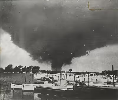
The Flint and Worcester tornadoes were the most infamous storms produced by a larger outbreak of severe weather that began in Nebraska, Iowa and Wisconsin, before moving across the Great Lakes states, and then into New York and New England. Other F3 and F4 tornadoes struck other locations in Massachusetts, Michigan, New Hampshire and Ohio.
Meteorological synopsis
On June 6, a surface low-pressure area formed over Northwestern New Mexico and eventually began to move northeastward into the Great Plains. On June 7, the low-pressure system moved into Southwestern Nebraska with a cold front extending a short distance westward into Northeastern Colorado, a dryline that extended south into Southwestern Texas, and a warm front that extended east-northeastward to near Omaha, Nebraska before turning east-southeastward into Southwestern Indiana. Temperatures across Kansas, Nebraska, and Iowa that afternoon in the area were up in the upper 70s to lower 90s Fahrenheit (26-32 C) while dewpoints were in the lower 60s to lower 70s (16-22 C). With shear values of 55 kn (102 km/h; 63 mph) in the upper atmosphere, the environment became extremely ripe for the development of severe weather and tornadoes throughout the afternoon and evening. A jet streak formed later that night after an upper-level low formed, which allowed the outbreak to go well into the overnight hours.
By June 8, the surface low and upper-level low had moved into Canada. The surface low occluded with the warm front over the Eastern Great Lakes into Ontario and New York and the cold front extending southwestward into Southeastern Iowa. A surface boundary formed, spanning from Eastern Upper Michigan southwestward into Southwestern Illinois. Upper-level wind shear values were even stronger on this day, reaching as high as 65 kn (120 km/h; 75 mph). Temperatures were in the upper 70s to upper 80s Fahrenheit (26-32 C) with dewpoints in the mid 60s to mid 70s (20-25 C). This allowed for a line of large and violent tornadic supercells to form across Eastern Lower Michigan into Northwestern Ohio. These storms marched eastward throughout the afternoon before weakening that evening. A sounding taken on June 8 revealed 4500+ J/kg CAPE.
On June 9, the cold front from the surface low over Eastern Ontario had moved into New England. A shortwave trough had formed over the region in the upper atmosphere, conjuring up extremely strong wind shear values of 100 kn (190 km/h; 120 mph). At the surface, temperatures were in the upper 70s to mid 80s Fahrenheit (26-30 C) with dewpoints in the mid 60s to lower 70s (18-20 C). Numerous supercell thunderstorms formed along the cold front, spawning wind, hail, and tornadoes before weakening and moving offshore that evening.
Sign in to keep reading
2 more chapters are free with a Lably account.
Confirmed tornadoes
June 7 event
June 8 event
June 9 event
Arcadia, Nebraska
This tornado formed south of Arcadia, Nebraska around 3:15 p.m. near the Middle Loup River. The tornado first struck a cemetery, where it snapped trees and threw headstones before crossing the river and striking a farm, causing the home to be partially destroyed, with the rest being twisted off its foundation. The tornado then struck another farm, completely destroying the home with the owner inside, who later succumbed to his injuries. The tornado then struck a home made of concrete blocks, completely leveling the home down to its foundation, and a vehicle on the property was thrown 300 yards away from the home and turned into a heap of scrap metal. The tornado reached a quarter mile wide as it struck the home of the Madsen family, where a family reunion was happening at the time of the tornado. The tornado struck the Madsen farm at peak intensity, resulting in the complete annihilation of the home, sweeping the structure off its foundation, and leaving nothing intact. All 10 occupants who were home at the time were killed as their bodies were thrown hundreds of yards among debris. After destroying the Madsen farm, the tornado remained over rural Valley County before lifting soon after. The tornado claimed 11 lives in total, and caused around $500,000 USD (1953) in damages.
Flint, Michigan
This catastrophic, large and violent, multi-vortex F5 tornado was one of the deadliest tornadoes ever recorded in the United States, devastating the Flint, Michigan suburb of Beecher. The tornado first formed at about 8:30 p.m. on June 8 north of Flushing, Michigan. The tornado than moved eastward along Coldwater Road, moving directly through Beecher, Michigan with little to no warning, obliterating almost every structure in its path. Multiple deaths were reported in 20 families, and it was reported that papers from Flint were deposited in Sarnia, Ontario, Canada, some 60 miles (100 km) east of Flint. Large sections of neighborhoods were completely swept away, with only foundations left. Trees were debarked and vehicles were thrown and mangled and the Beecher High School was heavily damaged. Many patrons at the North Flint Drive-in theater evacuated the drive-in in their vehicles. Some got into vehicle crashes in the ensuing panic to flee while others inadvertently drove into the path of the tornado after leaving the theater. The theater itself received only minor damage. The tornado then moved east-northeastward, causing additional damaged before dissipating near Columbiaville. One hundred and sixteen were killed, making it the tenth deadliest tornado in U.S. history. The death toll was surpassed by the 2011 Joplin tornado. It is also one of only two F5 tornadoes ever to occur in Michigan. Another F5 tornado would hit in Hudsonville on April 3, 1956.
Worcester, Massachusetts
The storm system that created the Flint tornado moved eastward over southern Ontario and Lake Erie during the early morning hours of June 9. As radar was still primitive (or nonexistent) in 1953, inadequate severe weather predictions resulted. (Even during the Super Outbreak of April 3, 1974, weather radar was still not up to this task; that outbreak resulted in a technological upgrade.) The Weather Bureau in Buffalo, New York merely predicted thunderstorms and said that "a tornado may occur." As early as 10:00 a.m. EST, however, the Weather Bureau in Boston anticipated the likelihood of tornadic conditions that afternoon but feared the word "tornado" would strike panic in the public, and refrained from using it. Instead, as a compromise, they issued New England's first-ever severe thunderstorm watch.
Rain fell across Worcester County throughout the day on June 9. In New York, a strong cluster of thunderstorms began to build, moving eastward into Massachusetts. At approximately 4:25 p.m., a funnel cloud formed near the Quabbin Reservoir near New Salem. Very soon after, the tornado developed in a forest outside of the rural community of Petersham. The tornado then proceeded to pass through a farm field, where it struck a farmhouse and killed two people. As the storm moved eastward at approximately 35 miles per hour (56 km/h), it hit the towns of Rutland and Holden, where 11 people were killed in total.
At about 5:00 p.m., the tornado moved into the city of Worcester, alarming many residents. According to eyewitness accounts, the storm moved in extremely quickly, shocking the townsfolk. "I saw it grow noticeably darker," said eyewitness George Carlson, "Then it hit. Houses tumbled, trees fell, and it was all over. The tornado was definitely discernible. Like when you can see the lines of rain in an approaching rainstorm," he added. The tornado, which had grown to one mile (1.6 km) in width, destroyed several structures in Northern Worcester, including parts of Assumption College. Other major structures included a newly built factory and a large residential development. Residential areas were devastated and entire rows of homes were swept away at possible F5 intensity.
At approximately 5:20 p.m., the tornado crossed the far north end of Lake Quinsigamond, and began to move through Shrewsbury. Transmission towers were snapped in half, cutting off power to thousands of people in Shrewsbury and the surrounding towns. Dozens of homes between Maple Avenue and Grafton Street were destroyed, some completely swept away. The funnel maintained its one-mile (1.6 km) width as it passed throughout much of Shrewsbury, and still dealt a high degree of damage when it moved through downtown Westborough, where it began curving towards the northeast in its final leg. In the storm's final moments, three were killed when Fayville Post Office in Southborough collapsed. Around the time it ended, at 5:45 p.m., a tornado warning was issued, although by then it was too late.
The final death toll was 94, the highest number of deaths ever resulting from an F4/EF4 tornado. 1,288 other people were injured.
1953 tornado season in perspective
The year 1953 saw some of the deadliest tornadoes in U.S. history, including the Waco tornado that hit on May 11, the Flint tornado of June 8, and the Worcester tornado on June 9. These 3 storms were also unique in occurring within a 30-day period.
Other severe tornadoes of 1953 hit Warner Robins, Georgia in April, San Angelo, Texas in May (same day as Waco), Port Huron, Michigan later in May, Cleveland in June (same day as Flint and the day before Worcester), and Vicksburg, Mississippi in December.