

Vũng Tàu, Ho Chi Minh City
Ward in Ho Chi Minh City, Vietnam
- 2 min read
- 5 chapters

Explore on Lably
ToursExplore Lably’s 3D toursGeography
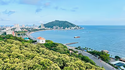
Vũng Tàu ward is located on the southern coast of Ho Chi Minh City, at the tip of the Vũng Tàu peninsula. It is about 95 km Southeast of Saigon ward, about 25 km Southwest of Bà Rịa ward. Vũng Tàu is bordered by:
- Tam Thắng ward to the East,
- Gành Rái Bay to the north and west
- The South China Sea to the south.
The Nghinh Phong cape, formerly known as Cap Saint-Jacques by the French, is the southernmost point of Ho Chi Minh City’s mainland.
According to Official Dispatch No. 2896/BNV-CQĐP dated May 27, 2025 of the Ministry of Home Affairs, following the merger, Vũng Tàu has a land area of 16.86 km², the population as of December 31, 2024 is 117,413 people, the population density is 6,963 people/km².
Sign in to keep reading
4 more chapters are free with a Lably account.
Etymology
In the 2025 administrative reorganization of communes, in order to commemorate and honor the ancestors who contributed to the development, preservation, and protection of the land of present-day Bà Rịa–Vũng Tàu area, the province in particular and Ho Chi Minh City in general have chosen new commune and ward names associated with famous tourist destinations, possessing long-standing historical and cultural elements, revolutionary lands such as Bà Rịa, Vũng Tàu, Đất Đỏ, and Hồ Tràm.
As Vũng Tàu ward corresponds to the historic downtown of the former city of Vũng Tàu (formerly known as Cap Saint-Jacques by the French), including the Front Beach, Strawberry Beach (Bãi Dâu), Pineapple Beach (Bãi Dứa), and part of Back Beach, Sao Mai Bến Đình quarter, also the Big Mount and Small Mount (Núi Lớn và Núi Nhỏ), it is responsible to bear the name of the former city.
History
On June 16, 2025, the National Assembly Standing Committee issued Resolution No. 1685/NQ-UBTVQH15 on the arrangement of commune-level administrative units of Ho Chi Minh City in 2025 (effective from June 16, 2025). Accordingly, the entire land area and population of Ward 1, Ward 2, Ward 3, Ward 4, Ward 5, Thắng Nhì and Thắng Tam wards of the former Vũng Tàu city will be integrated into a new ward named Vũng Tàu (Clause 102, Article 1).
The seat of Vũng Tàu ward is located at the city hall of the former Vũng Tàu city.
Administration
Vũng Tàu is divided into 42 neighborhoods, numbered from 1 to 42.
Notable People
- Lý Nhã Kỳ