

Ōita (city)
Prefecture capital and Core city in Kyushu, Japan
- 5 min read
- 12 chapters

Related on Lably
Through Population density and Unicameralism
Geography
Ōita city is located in east-central Ōita Prefecture, facing Beppu Bay on the Seto Inland Sea. The Ōno River flows from the south to the east, and the Ōita River flows from the west to the west, with the main urban center on the west side of the mouth of the Ōita River, with the Ōita Plain consisting of deltas and alluvial plains formed by the Ōita River and the Ōno River, and surrounding hills. The Takashima area in of the city is within the borders of the Seto Inland Sea National Park.
Neighboring municipalities
- Beppu to the northwest
- Bungo-Ōno to the south
- Taketa to the southwest
- Usuki to the southeast
- Yufu to the west
Climate
Ōita has a humid subtropical climate (Köppen Cfa) characterized by warm summers and cool winters with light to no snowfall. The average annual temperature in Ōita is 15.6 °C. The average annual rainfall is 1663 mm with September as the wettest month. The temperatures are highest on average in August, at around 26.3 °C, and lowest in January, at around 5.1 °C.
Sign in to keep reading
11 more chapters are free with a Lably account.
Demographics
Ōita is the most populous city in Ōita Prefecture. Per Japanese census data, the population of Ōita is as shown below
History
The area of Ōita city was part of ancient Bungo Province, and the location of the Bungo Kokubun-ji and presumably the Bungo kokufu were located in this area. According to the Bungo no Kuni Fudoki, the name Ōita was given by Emperor Keiko when he visited this area in the late Kofun period; however, the main urban center was the port of Funai (府内) on the coast. During the Kamakura period, the Ōtomo clan was appointed shugo of the province, and made Funai their jōkamachi. By the Sengoku period, the Ōtomo has conquered most of Kyushu and had embraced Nanban culture, with Funai becoming a stronghold of the Kirishitan religion and western technology. However, the Ōtomo were destroyed by the Shimazu clan and after the establishment of the Tokugawa shogunate, their territories were divided, with Funai becoming the center of Funai Domain ruled by the Ogyū-Matsudaira clan.
The town of Ōita was established on 1 May 1889 with the creation of the modern municipalities system, and was raised to city status in 1911. On 1 April 1997, it was designated as a core city with greater local autonomy.
On 1 January 2005, the town of Notsuharu (from Ōita District) and the town of Saganoseki (from Kitaamabe District) were merged into Ōita.
Government
Ōita has a mayor-council form of government with a directly elected mayor and a unicameral city council of 44 members. Ōita contributes 13 members to the Ōita Prefectural Assembly. In terms of national politics, the city is divided between the Ōita 1st district and Ōita 2nd district of the lower house of the Diet of Japan.
Economy
During the 1960s and 1970s, an industrial region was formed along the Beppu Gulf coast. Among the plants in the region were flagship plants of Nippon Steel and Showa Denko.
In the 1970s, Toshiba and Canon built and expanded their plants in inland area. By then, the city emerged as a major production center of electronics products such as LSIs and digital cameras.
The downtown and shopping districts are located to the north of Oita Station. However, the area has been gradually declining because the main commercial areas have been dispersed due to the construction of big shopping malls in the suburbs.
Education
National universities
- Oita University
Prefectural universities
- Oita Prefectural College of Arts and Culture
- Oita University of Nursing and Health Sciences
Private universities
- Beppu University – Oita Campus
- Nippon Bunri University
- Oita Junior College
- Ritsumeikan Asia Pacific University
Primary and secondary schools
Ōita has 54 public elementary schools, 25 public junior high schools, and two combined elementary/junior high schools operated by the city government. The city has 14 public high schools and one combined middle/high school operated by the Ōita Prefectural Board of Education, six private high schools and three private combined middle/high schools. The city also operates four and the prefecture operates one special education schools for the handicapped.
Transportation
Airport
Oita Airport is located in neighbouring Kunisaki, and is accessible by bus, taxi, private vehicle, and hovercraft.
Railways
The luxury Aru Ressha train was designed by Eiji Mitooka. It runs between Ōita and Hita and is in service to also revive tourism and the local economy. JR Kyushu - Nippō Main Line
- Nishi-Ōita - Ōita - Maki - Takajō - Tsurusaki - Ōzai - Sakanoichi - Kōzaki
JR Kyushu - Hōhi Main Line
- Takenaka - Naka-Handa - Ōita-Daigaku-mae - Shikido - Takio - Ōita
JR Kyushu - Kyūdai Main Line
- Bungo-Kokubu - Kaku - Minami-Ōita - Furugō - Ōita
Highways
- Higashikyushu Expressway
- National Route 10
- National Route 57
- National Route 197
- National Route 210
- National Route 217
- National Route 442
Ports
- Port of Oita
Sister cities
- Austin, Texas, United States, sister city since October 1990
- Aveiro, Portugal, sister city since October 1978
- Guangzhou, China, exchange promotion city partnership since September 1997
- Wuhan, China, friendship city since September 1979
Local attractions
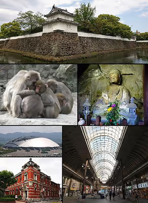
- Resonac Dome Oita (originally the Ōita Stadium), also known as Big Eye, is situated along the city expressway. It is the home field of the J.League football club Ōita Trinita and is used for large local events.
- Takasaki Mountain (高崎山) that borders Beppu is famous for wild monkeys, specifically the Japanese macaque. Facing the entrance to the Takasaki-yama park is the "Oita Marine Palace Aquarium", also known as "Umi-Tamago", or "Sea Egg".
Festivals and events
- The Ōita Tanabata Festival (大分七夕まつり, Ōita Tanabata Matsuri) is annually held on the first weekend of August. On the first night of the festival, an event called Funai Pacchin (府内戦紙) in which Matsuri floats depicting warriors are paraded through the central streets of the city is held.
Sports
Annual sporting events include:
- Beppu-Oita Mainichi Marathon, which traces a path between Ōita and its neighbouring city of Beppu. The competition has been held every year since 1952 and is classed as an IAAF Silver Label road race.
- The Kyūshū Ekiden, beginning in Nagasaki and ending in Fukuoka, the world's longest relay race
Sporting events held in Oita include:
- 1966 National Sports Festival of Japan
- 2001 Kirin Cup
- 2002 FIFA World Cup
- 2003, 2006, 2007 Kirin Challenge Cup
- 2005 J. League All-Star Soccer
- 2019 Rugby World Cup
Sports teams and facilities
Notable people from Ōita
- Mao Abe, singer-songwriter
- Takamasa Anai, judo wrestler
- Yuya Ando, baseball player
- Misa Etō, former Nogizaka46
- Eri Fukatsu, actress
- Sōsuke Genda, baseball player
- Arata Isozaki, architect
- Yūko Kotegawa, actress
- Atsuhiro Miura, football player
- Daisuke Miyazaki, handball player
- Tomiichi Murayama, 81st Prime Minister of Japan
- Shigeichi Nagano, photographer
- Chiyotaikai Ryūji, sumo wrestler
- Yūsuke Santamaria, tarento
- Rino Sashihara, HKT48, former AKB48
- Kenichi Shinoda, yakuza, sixth chairman of the Yamaguchi-gumi
- Skull Reaper A-ji, professional wrestler, mahjong player and politician
- Seiichi Uchikawa, baseball player
- Naomi Zaizen, actress