

Eastern Hemisphere
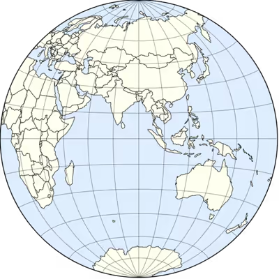
Half of Earth which lies east of the prime meridian
- 25 min read
- 8 chapters

Related on Lably
Through Prime meridian, Africa and Australia (continent)
Geography
The boundary line between the Western and Eastern Hemispheres is an almost perfect circle (the Earth is an oblate spheroid, i.e. wider around the equator). The position of this boundary line must be an arbitrary convention, unlike the equator (an imaginary line encircling Earth, equidistant from its poles, which divides the Northern and Southern hemispheres). The prime meridian at 0° longitude and the antimeridian, at 180° longitude, are the conventionally accepted boundaries, since they divide eastern longitudes from western longitudes. This convention was established in 1884 at the International Meridian Conference held in Washington, D.C., where the standard time concepts of Canadian railroad engineer Sir Sandford Fleming were adopted. The hemispheres agreed do not precisely correspond with continents. Portions of Western Europe, West Africa, Oceania, and extreme northeastern Russia are in the Western Hemisphere, in contrast to the split between the "Old World" and the "New World" or the Americas.
Alternatively, meridians of 20°W and the diametrically opposed 160°E are sometimes used outside of matters of physics and navigation. This arrangement is preferred by some since it includes all of the European and African mainlands as part of the Eastern Hemisphere. However, it also includes a small portion of northeast Greenland (typically reckoned as part of North America) and excludes more of eastern Russia and Oceania (e.g., New Zealand's two main islands). Prior to the global adoption of standard time, numerous prime meridians were decreed by various countries where time was defined by local noon.
The Indian Ocean is the only ocean located entirely in the Eastern Hemisphere. The centre of the Eastern Hemisphere is located in the Indian Ocean at the intersection of the equator and the 90th meridian east, 910 km west of Indonesia in the Ninety East Ridge. The nearest land is Simeulue Island at 2°35′N 96°05′E / 2.583°N 96.083°E.
The land mass of the Eastern Hemisphere is larger than that of the Western Hemisphere and has a wide variety of habitats. The center of all the land of the Eastern Hemisphere (excluding Antarctica) has been located at 30°00′00″N 62°15′00″E / 30.00000°N 62.25000°E in southern Afghanistan. Even though Russia has the largest amount of total land in the Eastern Hemisphere, the largest country entirely in the Eastern Hemisphere is China at 9,596,961 km2.
Countries in the Eastern Hemisphere
18 independent countries entirely in the Eastern Hemisphere have no land borders with other countries: Australia, Comoros, Federated States of Micronesia, Japan, Madagascar, Maldives, Malta, Marshall Islands, Mauritius, Nauru, Palau, Philippines, São Tomé and Príncipe, Seychelles, Solomon Islands, Sri Lanka, Tuvalu and Vanuatu. Fiji, Kiribati and New Zealand, which have land in both the Eastern and Western Hemisphere, are also borderless countries, while Brunei, Cyprus, Indonesia, Papua New Guinea and Timor-Leste are considered divided island countries, as they have land borders. The United Kingdom is another divided island country, though most of the country is in the Western Hemisphere. Bahrain and Singapore have no natural land borders, but are connected to Saudi Arabia and Malaysia by man-made bridges and causeways.
39 of Africa's 54 independent countries are entirely in the Eastern Hemisphere: the five largest are DR Congo at 2,345,409 km2, Sudan at 1,886,068 km2, Libya at 1,759,541 km2, Chad at 1,280,000 km2 and Niger at 1,267,000 km2.
When Sudan and South Sudan split into separate countries in 2011, Algeria became the largest country in Africa at 2,381,741 km2, and it straddles the prime meridian, with the greater proportion of its land being east of the prime meridian. Aside from Algeria, four additional African countries have land in both the Eastern and Western Hemispheres, and another ten are entirely in the Western Hemisphere.
34 of Europe's 44 independent countries are entirely in the Eastern Hemisphere, and besides Russia, all countries associated with the Eastern Europe region are entirely in the Eastern Hemisphere. Seven European countries are partially in the Eastern Hemisphere, and three are entirely in the Western Hemisphere (those being Iceland, Ireland and Portugal). The five largest European countries entirely in the Eastern Hemisphere are Ukraine at 603,628 km2, Sweden at 450,295 km2, Germany at 357,022 km2, Finland at 338,455 km2 and Poland at 312,696 km2. Norway is larger than Germany, Finland and Poland at 385,207 km2, though it has land in the Western Hemisphere, as the remote island of Jan Mayen is west of the prime meridian. Mainland France straddles the prime meridian, but the majority of the country's 543,940 km2 total land area in Europe is east of the prime meridian. The majority of Spain's 506,030 km2 total land area is west of the prime meridian.
Most Polynesian islands are entirely in the Western Hemisphere, including the countries of Samoa and Tonga and various semi-independent territories. However, no countries or territories in the neighboring regions of Melanesia and Micronesia are entirely in the Western Hemisphere, and only Fiji (Melanesia) and Kiribati (Micronesia) have any land in the Western Hemisphere.
Sign in to keep reading
7 more chapters are free with a Lably account.
Temperature records
Low temperatures
The majority of Antarctica's lowest recorded temperatures have been recorded in the larger Eastern Hemisphere portion. The lowest temperature ever recorded in the Eastern Hemisphere and the Southern Hemisphere was a −89.2 °C (−128.6 °F) reading at Antarctica's Vostok Station on July 21, 1983. This is also the lowest temperature ever recorded on earth. Outside of Antarctica, the lowest temperature ever recorded in the Western Hemisphere was a −69.6°C (−93.3°F) reading at the Klinck Automatic Weather Station in Greenland on December 22, 1991. This is also the lowest temperature ever recorded in the Northern Hemisphere. Byrd Automatic Weather Station is situated in the Western Hemisphere portion of Antarctica and recorded a −64.4 °C (−83.9 °F) reading on July 18, 1985.
High temperatures
The 56.7°C (134°F) temperature recorded in Death Valley, California on July 10, 1913 is the highest temperature ever recorded in the Northern Hemisphere and also in the Western Hemisphere. It is also the highest temperature ever recorded on earth. A 55.0°C (131°F) temperature recorded in Kebili, Tunisia, on July 7, 1931 is the second highest temperature ever recorded on Earth, and the highest in the Eastern Hemisphere. However, some weather historians question its accuracy. A 1922 reading of 58 °C (136.4 °F) in El Azizia, Libya, was long cited as the world record before the World Meteorological Organization decertified it in 2012 due to measurement errors. The Southern Hemisphere's highest recorded temperature is tied at 50.7 °C (123.3 °F) between Oodnadatta, South Australia on January 2, 1960 and Onslow, Western Australia on January 13, 2022.
The Italian island of Sicily is east of the prime meridian and recorded a 48.8°C (119.8°F) temperature on August 11, 2021, the highest associated with Europe. Mitribah, Kuwait recorded a temperature of 53.9°C (129.0°F) on July 21, 2016, which briefly became the highest associated with Asia and the entirety of Eurasia. Ahvaz, Iran recorded a 54°C (129.2°F) temperature on June 29, 2017, which remains the current record for Asia and Eurasia.
Zoology
Animals exclusively occurring in the Eastern Hemisphere include those associated with regions such as Australasia, East Asia, South Asia and Southeast Asia, like kangaroos, kiwis, koalas, pandas, orangutans and various species of tigers. Some African animals such as chimpanzees occur both east and west of the prime meridian in Africa, although giraffes, gorillas and zebras only occur in the Eastern Hemisphere portion. Bald eagles, the national symbol of the United States, can on rare occasion be found in the Eastern Hemisphere towards the end of Alaska's Aleutian Islands chain, which stretches across the North Pacific Ocean. While penguins are nearly exclusive to Antarctic-influenced regions of the Southern Hemisphere, they are widely found in both the Eastern and Western Hemispheres. Likewise, polar bears, which are exclusive to Arctic-influenced regions of the Northern Hemisphere, can be found in both the Eastern and Western Hemispheres.
Oceanography
Atlantic
The open Atlantic Ocean lies predominantly in the Western Hemisphere. One of the few Atlantic islands in the Eastern Hemisphere is Bouvet Island, a remote Norwegian volcanic island at 54°S 3°E in the southern Atlantic; it is one of the most isolated islands on earth and is largely covered by glaciers. The Mediterranean Sea, a marginal sea of the North Atlantic, is almost entirely in the Eastern Hemisphere, and some of its major islands include the Balearic Islands, Corsica, Crete, Malta, Sardinia and Sicily. Malta occupies a position between Sicily and the North African nations of Libya and Tunisia. Malta and Sicily are both geologically part of the African Plate rather than the Eurasian Plate. All of these islands are commonly grouped as Mediterranean islands rather than being grouped with open Atlantic islands.
Indian Ocean
The Indian Ocean's islands range from large continental landmasses to coral atolls and volcanic islands. The continental Madagascar lies off southeastern Africa, while Sri Lanka lies just south of India. Like Australia, Madagascar has many endemic animals, owing to its unique geological history. Further into the Indian Ocean are islands of volcanic geological origin. These include Mauritius, the Maldives, Réunion, the Kerguelen Islands and Australia's remote Heard Island and McDonald Islands, which contains Australia's only active volcano. Heard Island and McDonald Islands and the Kerguelen Islands are surrounded by cold sub-Antarctic waters, but are well north of Antarctica. The Cocos (Keeling) Islands are low coral atolls of volcanic origin, while Christmas Island is the emergent summit of a submarine mountain with a narrow fringing reef. The Seychelles are particularly diverse, with ancient granitic islands in the Inner Islands and low coralline islands in the Outer Islands, rather than forming a single volcanic chain like Mauritius. The volcanic North Sentinel Island is part of India's wider Andaman and Nicobar Islands, and is known for its hostile native population, who have had virtually no contact with the outside world since the earliest documentation of the island. The language and culture of the North Sentinelese are considered to be almost entirely unknown to outsiders.
Pacific
The Eastern Hemisphere includes the western portion of the Pacific Ocean, and some central portions. The Western Hemisphere has more remote sections of the Pacific Ocean, with some areas being devoid of islands for thousands of kilometers. The Australian mainland borders the Indian Ocean to the west, and the South Pacific and its marginal seas to the east, with the Great Barrier Reef being part of Australia's Pacific coast. Some parts of Australia's northern coast connect to South Pacific seas, while other parts of the northern coast connect to Indian Ocean seas. Australia is sometimes described as an "island continent" because it is a large landmass surrounded by ocean, rather than by continents. Among Australians, the country is also considered to border the Southern Ocean to its south, although many non-Australian geographers consider the Southern Ocean to begin much closer to Antarctica, with these geographers considering Australia's south to be bordering the Indian Ocean rather than the Southern Ocean. Some geographers also do not recognize the Southern Ocean as a distinct ocean, and consider Antarctica to be bordering the southern extents of the Atlantic, Indian and Pacific oceans. Other large landmasses situated in the western Pacific and its seas include Tasmania, New Guinea, New Zealand's North Island and South Island, Borneo, Taiwan, China's Hainan, and the main islands of Japan, the Philippines and Indonesia. The latter three countries comprise extensive archipelagos extending across the western Pacific and adjacent seas; the Philippines alone consists of more than 7,600 islands.
Beyond these large islands, the western Pacific contains numerous smaller volcanic and coral island groups in Melanesia and Micronesia. Melanesia consists of Fiji, New Caledonia, the Solomon Islands, and Vanuatu, with New Guinea often being included in a cultural sense, despite being much larger. Micronesia includes the Mariana, Caroline, Marshall and Gilbert island groups, and encompasses the independent nations of the Federated States of Micronesia, Kiribati, Nauru, Palau, and the Marshall Islands, along with the U.S. overseas territories of Guam and the Northern Mariana Islands. Japan's territory also extends through several volcanic island arcs, including the Izu Islands, the Bonin Islands and the highly remote Volcano Islands, while the Ryukyu Islands form a long volcanic chain between southern Japan and Taiwan. The volcanic islands of the western Pacific range from high volcanic islands to low coral atolls and typically support distinctive tropical and subtropical ecosystems.
The Indian Ocean and most of the tropical Pacific Ocean make up the Indo-Pacific bioregion. Areas like Northern Australia, Indonesia, Papua New Guinea, Taiwan, the Philippines and the islands of Melanesia and Micronesia all fall within this bioregion. Southern Australia, most of Japan and New Zealand do not fall within the Indo-Pacific bioregion, as they are not tropical areas. Japan's volcanic islands like the Ryukyu Islands are on the northern fringes of the bioregion. Some tropical areas of the Pacific in the Western Hemisphere still belong to the Indo-Pacific bioregion, including Hawaii, French Polynesia, Samoa and Tonga, although the tropical Pacific coast of Latin America is distinct.
Japan's northernmost island Hokkaido is known for its subarctic-influenced weather. Along with Japan, Russia also occupies land in the colder northwestern Pacific area. Sakhalin is a large Russian island between the Sea of Okhotsk and the Sea of Japan, and has significant mineral resources and oil/gas reserves. The Kuril Islands, another Russian possession, form a long volcanic chain extending from the Kamchatka Peninsula toward Hokkaido. Further north, Russia's Commander Islands form the westernmost geological segment of Alaska's Aleutian Islands arc. Despite being politically part of Russia, geological studies identify these islands as part of the Aleutian arc system. The Aleutian chain itself crosses the 180th meridian, placing some of its far-western islands technically in the Eastern Hemisphere despite their political association with Alaska. The Aleutian Islands and Russia's Pacific islands are often discussed in broader Arctic contexts rather than Pacific contexts, due to their different climates to the tropical islands of the Pacific.
Arctic
The Eastern Hemisphere portion of the Arctic Ocean contains numerous Russian island groups, including Novaya Zemlya, Severnaya Zemlya, the New Siberian Islands and Franz Josef Land, as well as Svalbard farther west under Norwegian sovereignty. Novaya Zemlya separates the Barents and Kara seas, Severnaya Zemlya lies between the Kara and Laptev seas, and Franz Josef Land forms one of the world's northernmost archipelagos. Wrangel Island, despite being Russian and lying in the Arctic Ocean, straddles the 180th meridian and therefore has land on both sides of the conventional Eastern–Western Hemisphere boundary.
Human history
The majority of land in the Eastern Hemisphere is part of Afro-Eurasia, which is sometimes referred to as the "Old World", and whose people had varying cultural linkages for centuries. Modern humans reached Eurasia from Africa roughly 120,000 years ago, with influential cultures subsequently developing in regions such as Europe and the Middle East. Major Pacific landmasses in the Eastern Hemisphere like Australia, New Guinea, Indonesia, the Philippines and Japan were settled by humans roughly 65,000 to 40,000 years ago. Madagascar, New Zealand and the islands of Melanesia and Micronesia were among some of the more recently settled areas of the Eastern Hemisphere. Owing to their isolated locations, Australia, New Zealand, Melanesia and Micronesia had little contact with the peoples of Afro-Eurasia until the Age of Discovery beginning in the 16th century, similar to the Americas or the "New World". The more remote populations living in Southern Africa were also generally isolated until the Age of Discovery. Following the Age of Discovery, Australia, New Zealand and certain African states like South Africa received colonial settler populations from Europe, which disrupted the native populations, with this occurring on a much larger scale throughout the Americas. Israel is often regarded as another example of a colonial settler society in the Eastern Hemisphere, although it received settlers later than the aforementioned areas.
Areas in the Eastern Hemisphere which are believed to have been unknown to humans until the Age of Discovery include the part of Antarctica in the Eastern Hemisphere, and certain remote islands, such as Bouvet Island, Christmas Island, Cocos (Keeling) Islands, Heard Island and McDonald Islands, the Kerguelen Islands, Lord Howe Island, Mauritius, Seychelles and Svalbard. The Bonin Islands were discovered uninhabited in 1543, however, they are theorized to have possibly had contact with Micronesians before this. Islands which were seemingly uninhabited before the Age of Discovery, like the Bonin Islands, Christmas Island and Lord Howe Island, developed high levels of endemism in their ecosystem due to their remoteness and lack of human interference. Mauritius was the only place in the world with the unique Dodo species, and it went extinct in 1662, following human discovery of the island. Christmas Island, Cocos (Keeling) Islands and Lord Howe Island are currently part of Australia and eventually received small human populations, as did the now Japanese-administered Bonin Islands. Mauritius and Seychelles became their own independent countries in 1968 and 1976, and are some of the only nation states in the world without true Indigenous populations, along with a few others in the Western Hemisphere such as Cape Verde.
Demographics and economy
82% of humans live in the Eastern Hemisphere, and 18% in the Western Hemisphere. The difference in population is less lopsided than that of the Northern Hemisphere and Southern Hemisphere, with 90% of humans living in the Northern Hemisphere, and only 10% in the Southern Hemisphere. In 2026, the states with the highest population density in the Eastern Hemisphere and the entire world were Macau and Monaco, which had 20,815 people and 18,333 people per kilometer. In 2026, the least densely populated states in the Eastern Hemisphere were Australia and Mongolia, which had 3 people and 2 people per kilometer. In 2025, Monaco had the highest life expectancy for both males and females in the Eastern Hemisphere and the entire world, with an average life expectancy of 84.6 years for males and 88.6 years for females. That year, Chad had the lowest life expectancy for males in the Eastern Hemisphere and the entire world (53.4 years), while Nigeria had the lowest life expectancy for females in the Eastern Hemisphere and the entire world (54.9 years).
The Eastern Hemisphere displays greater religious diversity than the Western Hemisphere, where the vast majority of countries are Christian (e.g. the whole Americas, Polynesian islands and the few European countries west of the prime meridian). Nearly all countries with Islam as the main religion are located in the Eastern Hemisphere, and the only Western Hemisphere countries with Islam as the main religion are the Northwestern African nations of Guinea, Guinea-Bissau, Ivory Coast, Mauritania, Morocco, Senegal, Sierra Leone and The Gambia. Islam is also the main religion in the African nations of Algeria, Burkina Faso and Mali, which straddle the prime meridian. Along with the European areas east of the prime meridian, Christianity is the most common religion in several Eastern Hemisphere areas with European colonial influence, such as Australasia, Melanesia, Micronesia, Southern Africa, the Philippines, and Timor-Leste. Israel has the largest Jewish population in the Eastern Hemisphere and the entire world, with 7,153,000 Jews living in the country in 2024. Other Eastern Hemisphere countries which rank high in global Jewish populations are Germany (125,000), Russia (123,000), Australia (117,000), South Africa (49,500) and Hungary (45,000). The majority of France's 438,500 Jews reside in the Eastern Hemisphere. India and Nepal are the only Hindu-majority countries in the world, and India has over a billion Hindus. Bangladesh, Pakistan and Indonesia have the three next highest total number of Hindus, although Islam is the majority religion in these countries. Mauritius has a 48% Hindu population. Most countries in Southeast Asia have Buddhist-majority populations. While Buddhism was historically a prominent religion in East Asia, the majority of the modern populations in East Asian countries do not follow any religion.
In 2016, the top 25 most visited cities entirely in the Eastern Hemisphere were Bangkok, Paris, Dubai, Singapore, Kuala Lumpur, Istanbul, Tokyo, Seoul, Hong Kong, Barcelona, Amsterdam, Milan, Taipei, Rome, Osaka, Vienna, Shanghai, Prague, Munich, Berlin, Mumbai, Riyadh, Chennai, Beijing and Sydney. Bangkok was the most visited city in the world in 2016. In 2025, the Eastern Hemisphere countries with the highest GDPs were China, Germany and Japan, while the Eastern Hemisphere countries with the lowest GDPs were the Marshall Islands, Nauru and Tuvalu (which had the lowest GDP in the world in 2025).
Countries and territories in the Eastern Hemisphere
Sovereign states in both hemispheres
Below is a list of the sovereign states in both the Western and Eastern hemispheres on the IERS Reference Meridian:
Mostly in the Eastern Hemisphere (with some land west of prime meridian)
- Denmark, due to the entirety of Greenland and the Faroe Islands. Denmark proper lies entirely within the Eastern Hemisphere. The default geographical coordinates for Denmark are 56°N 10°E, per the centroid of the country.
- Norway, due only to Jan Mayen. Mainland Norway, Svalbard and Bouvet Island lie entirely within the Eastern Hemisphere. The default geographical coordinates for Norway are 61°N 8°E, per the centroid of the country.
- The Netherlands has Caribbean overseas islands that lie entirely within the Western Hemisphere, while mainland Netherlands lies entirely within the Eastern Hemisphere. The default geographical coordinates for the Netherlands are 52°N 6°E, per the centroid of the country.
- France, the prime meridian passes through Puynormand (Gironde). About 1/3 of the country lies in the Western Hemisphere, including cities such as Nantes or Bordeaux, as well as the overseas territories of French Guiana, Guadeloupe and Martinique. The capital and most populated city Paris is entirely in the Eastern Hemisphere, along with the four next most populated cities (Lyon, Marseille, Toulouse, Nice), and other cities such as Cannes, Lille, Montpellier and Strasbourg. The offshore Mediterranean island of Corsica also lies within the Eastern Hemisphere, as do the overseas territories of the French Southern and Antarctic Lands, Mayotte and Réunion. The default geographical coordinates for France are 47°N 2°E, per the centroid of the country.
- Algeria, the prime meridian passes through Stidia. About 1/4 of the country, including Oran, Algeria's second-largest city, lies within the Western Hemisphere. The capital and largest city Algiers is within the Eastern Hemisphere. The default geographical coordinates for Algeria are 28°N 2°E, per the centroid of the country.
- Togo, the prime meridian passes near Tami (Tône Prefecture in Savanes Region). Most of Togo, including the capital Lomé, lies within the Eastern Hemisphere. The default geographical coordinates for Togo are 8°N 1°E, per the centroid of the country.
Mostly in the Western Hemisphere (with some land east of prime meridian)
- United Kingdom, the prime meridian passes through Greenwich, London. Most of the country lies within the Western Hemisphere, including the majority of England, and all of Scotland, Northern Ireland and Wales. The majority of the population also lies within the Western Hemisphere, including most of London's population and other major population centers such as Liverpool and Manchester. Most of its Overseas Territories are in the Western Hemisphere, including the Falkland Islands and those in the Caribbean. The British Indian Ocean Territory is in the Eastern Hemisphere, and major mainland settlements entirely in the Eastern Hemisphere include Cambridge, Essex, Ipswich, Kent and Norwich. The default geographical coordinates for the United Kingdom are 55°N 3°W, per the centroid of the country.
- Spain, the prime meridian passes through Castellón de la Plana (Valencian Community). Most of Spain, including the capital Madrid, the Canary Islands and the southern half of its Mediterranean territorial waters, lies within the Western Hemisphere. Spanish, British (Gibraltar) Moroccan and Algerian Mediterranean waters are the only part of the Mediterranean Sea located in the Western Hemisphere. Major Spanish settlements in the Eastern Hemisphere include Barcelona and the northern Mediterranean island of Mallorca. The city of Valencia is just west of the prime meridian, although the greater Valencian Community region has areas in the Eastern Hemisphere. Aside from Barcelona, the rest of the Catalonia region is also east of the prime meridian. Catalonia has pushed for independence in the past, and if it eventually achieves this, it would become a country entirely within the Eastern Hemisphere. The default geographical coordinates for Spain are 40°N 4°W, per the centroid of the country.
- Mali, the prime meridian passes through the municipal area of Gao. Most of Mali, including the capital Bamako, lies within the Western Hemisphere. The default geographical coordinates for Mali are 17°N 4°W, per the centroid of the country.
- Burkina Faso, the prime meridian passes through Lalgaye. Most of the country, including the capital Ouagadougou, lies within the Western Hemisphere. The default geographical coordinates for Burkina Faso are 12°N 1°W, per the centroid of the country.
- Ghana, the prime meridian passes through Tema. Most of Ghana, including the capital Accra, lies within the Western Hemisphere. The default geographical coordinates for Ghana are 8°N 1°W, per the centroid of the country.
Below is a list of additional sovereign states which are in both the Western and Eastern hemispheres along the 180th meridian. France and the United Kingdom are not listed below due to their inclusion above, though both have Western Hemisphere territories east of the 180th meridian, including France's Clipperton Island, French Polynesia and Wallis and Futuna, and the United Kingdom's Pitcairn Islands. France also has the Eastern Hemisphere territory of New Caledonia, to the west of the 180th meridian. With the exception of the United States (due to Wake Island, Guam and the Northern Mariana Islands), the places below are located on just one side of the International Date Line, which curves around them.
Mostly in the Eastern Hemisphere (with some land east of 180th meridian)
- Russia, the 180th meridian passes through Chukotka Autonomous Okrug. Its portion lying east of the 180th meridian is the only part of the country lying in the Western Hemisphere. This far eastern part of Russia in the Western Hemisphere is also geologically part of the North American Plate, rather than the Eurasian Plate like with much of the country. The default geographical coordinates for Russia are 66°N 94°E, per the centroid of the country.
- Kiribati, the 180th meridian passes close to Arorae. The country has both the Equator and the 180th meridian (antimeridian) crossing through its territory. It is the only country located in four hemispheres. The capital South Tarawa lies in the Eastern Hemisphere and Northern Hemisphere. Over half of Kiribati's population lives on South Tarawa. The default geographical coordinates for Kiribati are 1°N 173°E, per the centroid of the country.
- Fiji, the 180th meridian passes close to its dependency Rotuma and passes through Taveuni. The capital Suva is in the Eastern Hemisphere. The default geographical coordinates for Fiji are 18°S 179°E, per the centroid of the country.
- New Zealand's two main islands lie within the Eastern Hemisphere; but Chatham Islands and Kermadec Islands, as well as the self-governing states of the Cook Islands and Niue and the dependent territory of Tokelau, lie east of the 180th meridian. The default geographical coordinates for New Zealand are 42°S 173°E, per the centroid of the country.
Mostly in the Western Hemisphere (with some land west of 180th meridian)
- United States, the 180th meridian passes through the Aleutian Islands (Alaska). Except for the portion of Aleutian Islands lying west of the 180th meridian, Guam, the Northern Mariana Islands, and Wake Island, most of the country lies in the Western Hemisphere, east of the 180th meridian. Guam and the Northern Mariana Islands are both overseas territories in the Micronesia region, while Wake Island is an uninhabited island in the central Pacific, politically grouped with other uninhabited central Pacific islands (under the name U.S. Minor Outlying Islands). The Aleutian islands which are in the Eastern Hemisphere are the ones belonging to the Near Islands and Rat Islands groups, ranging from 51°N 179°E to 52°N 172°E. Semisopochnoi Island is the first island in the Aleutian chain which crosses over into the Eastern Hemisphere, and the remaining islands in the chain from that point on include Agattu, Alaid Island, Amchitka Island, Attu Island, Buldir Island, Davidof Island, Khvostof Island, Kiska, Little Kiska Island, Little Sitkin Island, Nizki Island, Segula Island and Shemya, among others. The default geographical coordinates for the United States are 40°N 100°W, per the centroid of the country.
Sovereign states entirely in the Eastern Hemisphere
Africa
- Angola
- Benin
- Botswana
- Burundi
- Cameroon
- Central African Republic
- Chad
- Comoros
- Democratic Republic of Congo
- Djibouti
- Egypt
- Equatorial Guinea
- Eritrea
- Eswatini
- Ethiopia
- Gabon
- Kenya
- Lesotho
- Libya
- Madagascar
- Malawi
- Mauritius
- Mozambique
- Namibia
- Niger
- Nigeria
- Republic of the Congo
- Rwanda
- Sao Tome and Principe
- Seychelles
- Somalia
- South Africa
- South Sudan
- Sudan
- Tanzania
- Tunisia
- Uganda
- Zambia
- Zimbabwe
Asia
- Afghanistan
- Armenia
- Azerbaijan
- Bahrain
- Bangladesh
- Bhutan
- Cambodia
- China (including Hong Kong, Macau and Taiwan)
- Georgia
- India
- Indonesia
- Iran
- Iraq
- Israel
- Japan
- Jordan
- Kazakhstan
- Kuwait
- Kyrgyzstan
- Laos
- Lebanon
- Malaysia
- Maldives
- Mongolia
- Myanmar
- Nepal
- North Korea
- Oman
- Pakistan
- Palestine
- Philippines
- Qatar
- Saudi Arabia
- Singapore
- South Korea
- Sri Lanka
- Syria
- Tajikistan
- Thailand
- Timor-Leste
- Turkey
- Turkmenistan
- United Arab Emirates
- Uzbekistan
- Vietnam
- Yemen
Europe
- Albania
- Andorra
- Austria
- Belarus
- Belgium
- Bosnia and Herzegovina
- Bulgaria
- Croatia
- Cyprus
- Czechia
- Estonia
- Finland (including Åland)
- Germany
- Greece
- Hungary
- Italy
- Latvia
- Lithuania
- Luxembourg
- Malta
- Moldova
- Monaco
- Montenegro
- North Macedonia
- Poland
- Romania
- San Marino
- Serbia (including Kosovo)
- Slovakia
- Slovenia
- Sweden
- Switzerland
- Ukraine
- Vatican City
Oceania
- Australia (including Christmas Island, Cocos (Keeling) Islands, Heard Island and McDonald Islands and Norfolk Island)
- Federated States of Micronesia
- Marshall Islands
- Nauru
- Palau
- Papua New Guinea
- Solomon Islands
- Tuvalu
- Vanuatu
Former sovereign states entirely in the Eastern Hemisphere
Africa
- United Arab Republic (Egyptian part)
Asia
Europe
Eastern Hemisphere organizations
Asia Cooperation Dialogue (ACD)
- Afghanistan
- Bahrain
- Bhutan
- Brunei
- Cambodia
- China
- India
- Indonesia
- Iran
- Japan
- Kazakhstan
- Kuwait
- Kyrgyzstan
- Laos
- Malaysia
- Mongolia
- Myanmar
- Nepal
- Oman
- Pakistan
- Philippines
- Palestine
- Qatar
- Russia
- Saudi Arabia
- Singapore
- South Korea
- Sri Lanka
- Tajikistan
- Thailand
- Turkey
- United Arab Emirates
- Uzbekistan
- Vietnam
Association of Southeast Asian Nations (ASEAN)
Benelux
Bucharest Nine (B9)
Central European Defence Cooperation (CEDC)
Central European Free Trade Agreement (CEFTA)
- Albania
- Bosnia and Herzegovina
- Bulgaria
- Croatia
- Czechia
- Hungary
- Kosovo
- Moldova
- Montenegro
- North Macedonia
- Poland
- Romania
- Serbia
- Slovakia
- Slovenia
Central European Initiative (CEI)
- Albania
- Belarus
- Bosnia and Herzegovina
- Bulgaria
- Croatia
- Czechia
- Hungary
- Italy
- Moldova
- Montenegro
- North Macedonia
- Poland
- Romania
- Serbia
- Slovakia
- Slovenia
- Ukraine
Common Market for Eastern and Southern Africa (COMESA)
- Burundi
- Comoros
- DR Congo
- Djibouti
- Egypt
- Eritrea
- Eswatini
- Ethiopia
- Kenya
- Libya
- Madagascar
- Malawi
- Mauritius
- Rwanda
- Seychelles
- Somalia
- Sudan
- Tunisia
- Uganda
- Zambia
- Zimbabwe
Collective Security Treaty Organisation (CSTO)
Commonwealth of Independent States (CIS)
Craiova Group
East African Community
Economic Cooperation Organization (ECO)
Eurasian Economic Union (EEU)
GUAM Organization for Democracy and Economic Development
Gulf Cooperation Council (GCC)
Indian Ocean Rim Association (IORA)
- Australia
- Bangladesh
- Comoros
- France
- India
- Indonesia
- Iran
- Kenya
- Madagascar
- Malaysia
- Maldives
- Mauritius
- Mozambique
- Oman
- Seychelles
- Singapore
- Somalia
- South Africa
- Sri Lanka
- Tanzania
- Thailand
- United Arab Emirates
- Yemen
Intergovernmental Authority on Development (IGAD)
Lublin Triangle
Melanesian Spearhead Group (MSG)
Organization of the Black Sea Economic Cooperation (BSEC)
Open Balkan
Organization of Turkic States (OTS)
Regional Comprehensive Economic Partnership (RCEP)
- Australia
- Brunei
- Cambodia
- China
- Indonesia
- Japan
- Laos
- Malaysia
- Myanmar
- New Zealand
- Philippines
- Singapore
- South Korea
- Thailand
- Timor-Leste
- Vietnam
Salzburg Forum (SF)
South Asian Association for Regional Cooperation (SAARC)
South-East European Cooperation Process (SEECP)
- Albania
- Bosnia and Herzegovina
- Bulgaria
- Croatia
- Greece
- Kosovo
- Moldova
- Montenegro
- North Macedonia
- Romania
- Serbia
- Slovenia
- Turkey
Southern African Customs Union (SACU)
Southern African Development Community (SADC)
- Angola
- Botswana
- Comoros
- DR Congo
- Eswatini
- Lesotho
- Madagascar
- Malawi
- Mauritius
- Mozambique
- Namibia
- Seychelles
- South Africa
- Tanzania
- Zambia
- Zimbabwe