

Sukhothai Historical Park
UNESCO World Heritage Site in Sukhothai province Thailand
- 30 min read
- 3 chapters

Related on Lably
Through UNESCO
The city's walls form a rectangle about 2 km (1.2 mi) east-west by 1.6 km (0.99 mi) north-south. There are 193 ruins on 70 km2 (27 sq mi) of land. There is a gate in the centre of each wall. Inside are the remains of the royal palace and twenty-six temples, the largest being Wat Mahathat. The park is maintained by the Fine Arts Department of Thailand with help from UNESCO, which has declared it a World Heritage Site. Each year, the park welcomes thousands of visitors.
History
Settlement to the 11th century
The traditions that report the founding of the town disagree with one another, and none of them is contemporary. One chronicle tradition places it in 494 CE, followed by the twin city of Chaliang. The Legend of the Arhat gives 679 CE instead and names the founder as Indrajayadhirāja, from a city called Nakhon Luang, who was deposed in 687 by Balidhiraja, the elder son of Kalavarnadisharaja of Lavo. A local textual tradition then brings Sukhothai and Lavo under the authority of Padumasūriyavaṁśa, presented as the first Siamese sovereign, whose reign is conventionally dated to the second half of the 8th century.
Tatsuo Hoshino reaches a comparable position from the Chinese records. The Cefu Yuangui and the Book of Tang have the territory of Qiān, centred at Si Thep, bordering to the north on Duō Mó Cháng, which he places in the Yom and Nan basins. On that reading the Sukhothai–Chaliang region was subordinate to Si Thep between the 8th and 10th centuries.
The town is generally presumed to have been abandoned during the 9th and 10th centuries after an incursion attributed to the legendary Khom polity of Suvarṇakōmakam, although a separate tradition has Sukhothai taking an active part in the succession of the Dvaravati polity of Sambuka in the same period. It is reported to have been taken in 957 by the Mon monarch Abhayakamini, and to have declared its independence in 1017. Standing on the routes that joined the Mon city-states to the west, the Tai polities to the north and the Xiān polities of the lower Chao Phraya River to the south, it is thought to have grown into a regional entrepôt and to have reached the level of a city-state by no later than 1127.
The site to the 13th century
Chris Baker and Pasuk Phongpaichit describe the site in two stages. Around the town lie some thirty moated sites resembling those of the Chao Phraya plain and the Isan plateau over the previous five centuries, and to the west of the town are earthworks that direct water down from the hills in what they call the characteristic style of Tai settlement. A Khmer-style town appeared probably around 1200; later in the 13th century a much larger walled and moated town of 1.9 by 1.4 kilometers was built immediately to the south, which they read as marking an influx of people. That newer town has the Angkor-influenced plan, square, with a relic stupa near the centre and a baray outside the walls.
Monuments in Angkorian style stand in the park, among them the Ta Pha Daeng shrine, Wat Phra Phai Luang, and Wat Sisawai. A Buddha image of the Jayabuddhamahānātha type appears to have been enshrined at Wat Phra Phai Luang by 1191. These images bore Jayavarman VII's own features and were sent, by the Preah Khan inscription of that year, to twenty-three cities; Baker and Pasuk hold that without corroborating evidence of military or administrative power a better characterisation of the gift is cultural diplomacy. Whether the images left Angkor at all is disputed. Pises Jiajanpong reads the Bayon inscriptions, which record particular images as established there, as casting doubt on it; Wyatt answers that portable replicas stood at Angkor for the annual ceremonies and points to finds at Sukhothai and Phimai. About 50 kilometers north of Sukhothai lies Si Satchanalai or Sri Sajanalaya. The Ta Pha Daeng shrine carries no name of its own from the period. The one it is known by is local and later, and no name for it has been found in any inscription. Sujit Wongthes places it south of and outside the earlier town at Wat Phra Phai Luang, and north of the inner town of the later walled one.
Sukhothai has conventionally been described as an outpost of the Khmer Empire named Sukhodaya. How far Angkorian authority actually reached is disputed. Baker and Pasuk find no administrative trace of it west of the Khmer country. The plain has yielded none of the temple-endowment inscriptions characteristic of Angkorian provinces, and Jayavarman VII's hospital foundations reach no further west than Prachin Buri in eastern Thailand, which they take to show cultural influence rather than administration.
Lines active in the upper valley
Several ruling lines are recorded in the upper valley before 1239, and the chronicle and epigraphic traditions do not agree on how they were connected. The Northern Chronicle places the origins of Uthong I at Chaliang, from where he moved south in the mid-12th century and took the vacant throne of Suphannaphum in 1163. The Ayutthaya Testimonies make him the younger brother of Pra Poa Noome Thele Seri, who went on to rule Phrip Phri in 1188.
A second line is known from epigraphy rather than chronicle. The Wat Si Chum Inscription names Sri Naw Nam Thum as lord of Chaliang and Sukhothai in the late 12th and early 13th centuries. He is generally taken to have built that position through his son Pha Mueang, ruler of Mueang Rat, and through Pha Mueang's marriage to a princess under the suzerainty of Jayavarman VII. Pha Mueang held Angkorian honours of his own, a title, a regalia sword and the marriage, which is why Baker and Pasuk read the contest that followed as one between local lords who both stood in the Angkorian orbit rather than between a Tai party and a Khmer one.
A third line is given by the Ayutthaya Testimonies, which make Candraraja ruler first of Vicitraprakāra, identified with Kamphaeng Phet, and then of Sukhothai, to which he moved his seat, and the father of Bang Klang Hao. On that account the family that took the town in 1239 was already established in the upper valley, and the event was a change of hands among neighbours rather than the arrival of a new people.
Sukhothai in the 13th century
Prior to the 13th century, a succession of Tai kingdoms existed in the northern highlands including the Ngoenyang (centered on Chiang Saen, predecessor of Lan Na) kingdom and the Heokam (centered on Chiang Hung, modern Jinghong in China) kingdom of Tai Lue people. Sukhothai has been described as a trade centre within the orbit of Lawo. The migration of Tai people into the upper Chao Phraya valley was somewhat gradual.
Sri Naw Nam Thum ruled Sukhothai together with the neighbouring city of Si Satchanalai in the late 12th and early 13th centuries, and lost the town about 1180 to Khom Sabat Khlon Lamphong.
Two brothers, Pho Khun Bang Klang Hao and Pho Khun Pha Mueang, took Sukhothai in 1239. Khun (ขุน), before it became a Thai feudal title, was a Tai title for a ruler of a fortified town and its surrounding villages, together called a muang; in older usage prefixed pho (พ่อ) 'father', Comparable in sound and meaning to rural English 'paw'. Bang Klang Hao ruled Sukhothai as Sri Indraditya and began the Phra Ruang dynasty. He expanded his kingdom to bordering cities. At the end of his reign in 1257, the Sukhothai Kingdom covered the entire upper valley of the Chao Phraya River (then known simply as Menam, 'mother of waters', the generic Thai name for rivers.)
The event is read in two ways. In the account of Griswold and Prasert na Nagara, Khom Sabat Khlon Lamphong was the commander of a Khmer garrison and 1238 the liberation of Sukhothai from Khmer suzerainty under a Tai dynasty. More recent work has withdrawn the supports for that reading. The etymological analysis finds no element of rank in the name, and the term Khom is not a reliable ethnic marker. In its place he is treated as a local figure who kept political affiliations with Lavo, itself under the influence of the Angkorian Mahidharapura line by the 1180s. Chris Baker and Pasuk Phongpaichit read the inscription as recording a victory by one local lord associated with Angkor over another holding a Khmer title, Pha Mueang the victor having himself received a title, a regalia sword and a princess in marriage from the ruler at Angkor. Sukhothai remained the centre of Tai power in the upper valley until the end of the 14th century.
Traditional Thai historians considered the founding of the Sukhothai Kingdom as the beginning of the Thai nation because little was known about the kingdoms prior to Sukhothai. Modern historical studies demonstrate that Thai history began before Sukhothai. Yet the foundation of Sukhothai is still a celebrated event.
Expansions under Ramkamhaeng
Pho Khun Ban Muang and his brother Ram Khamhaeng expanded the Sukhothai Kingdom. To the south, Ramkamhaeng subjugated the kingdoms of Supannabhum and Sri Thamnakorn (Tambralinga) and, through Tambralinga, adopted Theravada as the state religion. To the north, Ramkamhaeng put Phrae and Muang Sua (Luang Prabang) under tribute.
To the west, Ramkhamhaeng helped the Mons under Wareru (who is said to have eloped with Ramkamhaeng's daughter) to free themselves from Pagan domination and establish a kingdom at Martaban (they later moved to Pegu). So, Thai historians considered the Kingdom of Martaban a Sukhothai tributary. In practice, Sukhothai domination may not have extended that far.
With regard to culture, Ramkhamhaeng had the monks from Sri Thamnakorn propagate the Theravada religion in Sukhothai. In 1283, Ramkamhaeng is said to have invented Thai script, incorporating it into the controversial Ramkamhaeng Stele discovered by Mongkut 600 years later.
It was also during this period that the first contacts with Yuan dynasty were established and Sukhothai began sending trade missions to China. One well-known export of Sukhothai was the Sangkalok (Song dynasty pottery). This was the only period that Siam produced Chinese-styled ceramics, which fell out of use by the 14th century.
Decline and domination of Ayutthaya
Sukhothai domination was short-lived. After the death of Ramkhamhaeng in 1298, Sukhothai's tributaries broke away. Ramkhamhaeng was succeeded by his son, Loe Thai. The vassal kingdoms followed, first Uttaradit in the north, then the Laotian kingdoms of Luang Prabang and Vientiane (Wiangchan). In 1319 the Mon state to the west broke away, and in 1321 the Lanna absorbed Tak, one of the oldest towns under the control of Sukhothai. To the south, the powerful city of Suphanburi also broke free early in the reign of Loe Thai. Thus the kingdom was quickly reduced to its former local importance only. Finally in 1378, the armies of the expanding Ayutthaya Kingdom invaded and forced Sukhothai's King Thammaracha II to yield to this new power. After the Battle of Sittaung River in 1583, King Naresuan of Phitsanulok (and crown prince of Ayutthaya) forcibly relocated people from Sukhothai and surrounding areas to the Southern Central plain, due to the war with the Burmese and an earthquake.
Later development
Sukhothai repopulated again but declined due to successive Burmese–Siamese wars, especially the Burmese–Siamese War (1765–67). In 1793 Rama I, after establishing Bangkok as a new capital city of the kingdom, founded New Sukhothai in Thani, 12 km (7.5 mi) to the east of old Sukhothai, thus abandoning Sukhothai. In 1801 Rama I commissioned the construction of many royal temples in the capital city. He ordered that old Buddha images be brought to Bangkok from the ruined temples around the country. One of the Buddha images is the eight metre (25-foot) tall bronze Phra Sri Sakyamuni (Thai: พระศรีศากยมุนี; RTGS: phra si sakkayamuni), the principal Buddha image of Wat Suthat, which was the principal Buddha image of Wat Mahathat, the biggest temple in Sukhothai. In 1833 Mongkut, during his monkhood, travelled to Sukhothai and discovered the controversial Ramkhamhaeng stele in Wat Mahathat and other artifacts, now in the National Museum in Bangkok. The formal name of this stone is The King Ram Khamhaeng Inscription Documentary heritage inscribed on the Memory of the World Register in 2003 by UNESCO.
In 1907, Vajiravudh, as crown prince, conducted a two-month archaeological field trip to Nakhon Sawan, Kampheang Phet, Sukhothai, Si Satchanalai, Uttaradit, and Pitsanulok. He later published "Phra Ruang City Journey" (Thai: เที่ยวเมืองพระร่วง; RTGS: Thiao Muang Phra Ruang) to promote historical and archaeological study by the public. The work has been used by later archaeologists and historians including Damrong Rajanubhab, the founder of the modern Thai educational system and George Coedès, a 20th-century scholar of southeast Asian archaeology and history.
In July 1988 the historical park was officially opened. On 12 December 1991, it was declared a World Heritage Site as part of the Historic Town of Sukhothai and Associated Historic Towns together with the associated historical parks in Kamphaeng Phet and Si Satchanalai.
Sign in to keep reading
2 more chapters are free with a Lably account.
Management
Sukhothai Historical Park is managed by the Fine Arts Department, Ministry of Culture. The department began restoring and presenting the ancient city in 1961. The protection of the area was first announced in the Royal Gazette on 6 June 1962. The enabling law is the Act on Ancient Monuments, Antiques, Objects of Art and National Museums, B.E. 2504 (1961) as amended by Act (No. 2), B.E. 2535 (1992).
Sights
A study of the geological materials used in the park, published by Vimoltip Singtuen and colleagues in 2024, found its sema or boundary stones to be mainly slate and phyllite. That is unlike the sandstone used for them on the Khorat Plateau.
Wat Mahathat
Wat Mahathat or Mahathat Temple (Thai: วัดมหาธาตุ) is the largest temple in Sukhothai Historical Park. The temple's name translates to 'temple of the great relic'. It is generally held to have been founded by Sri Indraditya as the main temple of the city and of the Sukhothai Kingdom, and was enlarged at the end of the 13th century and during the 14th. Baker and Pasuk attribute that expansion in part to the Sinhalese craftsmen Si Sattha brought, and record a frieze of walking monks around the base of the relic stupa that became a Sukhothai motif.
The design is based on a mandala, representing the universe, with a principal stupa surrounded by smaller stupas in eight directions. Construction of the principal stupa, which enshrines relics of the Buddha, is conventionally placed at about 1345. The main stupa has the shape of a lotus bud, which characterizes Sukhothai architectural arts. Its base carries 168 figures of disciples of the Buddha, standing and walking with their hands clasped in salutation, modelled in the lime mortar conventionally called stucco. Pierre Baptiste has compared a stucco head of a Buddha or a disciple in the Guimet Museum with these figures and dated it with them. The head, MA 13121, was bought at auction in 2021, and he thinks it was probably found at the site before restoration began there in 1961.
Of the eight smaller stupas, the four at the corners are in Mon Haripunchai–Lanna style and the four between them show Khmer influence. Two nine-metre-tall (30 ft) standing Buddha images called Phra Attharot (Thai: พระอัฏฐารส) flank the main stupa. The temple also includes an assembly hall (vihara), mandapa, ordination hall, and 200 subordinate stupas.
Noen Prasat
Noen Prasat or Palace Hill (Thai: เนินปราสาท) is the remains of the royal palace of the Kingdom of Sukhothai. The Noen Prasat was discovered in 1833 by Mongkut, who had made a pilgrimage to the north of Siam as a monk. The palace was built on a square base with the dimensions of 200 x 200 meters. Nearby were two small ponds where the archaeologists found the remains of terracotta pipes which probably been used to supply water from a city lake to the ponds. In the southwest, there are the remains of a 1.5-meter-high (4.9 ft) brick platform on which they found ashes and bones inside, so It can be assumed that it was the royal cremation place. The Ramkhamhaeng stele was discovered here by Mongkut. He also discovered the so-called "Manangasila Throne" (Thai: พระแท่นมนังคศิลาอาสน์), an approximately 1m x 2, 50m x 15 cm large slab of gray stone, which is decorated with lotus petals depiction. The Ramkhamhaeng Stele says that Ramkhamhaeng erected this stone throne in the sugar palm grove. Mongkut took these finds to Bangkok.
Ramkhamhaeng National Museum
Ramkhamhaeng National Museum (Thai: พิพิธภัณฑสถานแห่งชาติรามคำแหง) is a branch of the National Museum of Thailand in the Sukhothai Historical Park. It was opened in 1964 by Thailand's King Bhumibol Adulyadej and Queen Sirikit. More than 2,000 artifacts were donated from Phra Ratchaprasitthikhun, the abbot of Ratchathani Temple. Locals also contributed to the collection by donating many historical objects. Most of the objects on display in the main museum building come from Sukhothai; others were found in Si Satchanalai, Kamphaeng Phet, Phichit and Phetchabun. The collection includes Buddha images and Hindu god sculptures from Wat Phra Phai Luang and Wat Mahathat. There are also sculptures of the pre-Sukhothai period, about the 13th century, Sukhothai artifacts of the 14th and 15th centuries, and early Ayutthaya artifacts of about 1351 to 1488. Displayed with them is porcelain of the Yuan, Ming and Qing dynasties, found during the excavations in Sukhothai and Si Satchanalai.
Wat Si Sawai
Wat Si Sawai or Si Sawai Temple (Thai: วัดศรีสวาย) is one of the oldest temples in Sukhothai. The temple was founded in the late-12th or early-13th century as a Hindu shrine for Vishnu and the place for the Thiruppavai ceremony, before the events of 1238 and the foundation of the Sukhothai Kingdom. The temple has three well-preserved laterite prangs, representing the Hindu trinity, enclosed by a double rampart and a moat. The lower parts of prangs are apparently Khmer, while the upper have been expanded or renovated by Thais in brick and stucco. The central prang is held in Lavo or Hindu-style. Each prang contains a cella, possibly a podium for lingam and crypt. There are few remaining stucco works on the top of central prang. Later around the 14th century the temple was converted to the needs of the Buddhist faith: vihara were added to the south of the central prang. Numerous Chinese porcelains and Hindu god statues had been found in the area. One of artifacts is the Shiva statue discovered by Vajiravudh in 1907.
Wat Phra Phai Luang
Wat Phra Phai Luang (Thai: วัดพระพายหลวง) was the ritual center of Sukhothai and the biggest temple in the city area. Built in the late 12th century, in the reign of Jayavarman VII, when the town stood within the Lavo and Angkorian sphere. The building is about 25 by 40 meters and stands in a large moated precinct. Betty Gosling argues that it was built as a Theravada rather than a Mahayana foundation, which does not follow from the style of its architecture; David K. Wyatt, who reports her reading, notes that the site is little studied. After 1238 and the building of Wat Mahathat it lost its main ceremonial role and became a Theravada Buddhist temple.
Similar to Wat Si Sawai, the temple has three laterite prang, but only one is still preserved in good condition. Archaeologists suspect that the three prangs originally stood on a common laterite base. All three prangs were open to the east, with doors flanked by columns which carry a richly decorated tympanum depicting scenes from the life of Buddha. The doors on the other three sides were so-called "false doors". The complex is enclosed by a double moat. The outer moat is 600 meters long and is fed by the Lam-Pan River. In the north-west of the prang complex are the remains of late 14th century vihara, mandapa and a small ordination hall with eight Bai Sema.
The temple shows the transition of Khmer art to Thai art. In the 14th century the prang was renovated with elaborate stucco in leaf and frame patterns, which became a basic pattern of Thai art. Most of the stucco is now kept at the Ramkhamhaeng National Museum.
Wat Sa Si
Wat Sa Si (Thai: วัดสระศรี) is a small temple close to Ramkhamhaeng Monument. Wat Sa Si is beautifully situated in the midst of Traphang-Trakuan lake northwest of Wat Mahathat. Due to its location, the temple is one of the most beautiful place in Sukhothai. The temple has a Lanka styled stupa. The vihara of Wat Sa Si is situated on the east side of the stupa. Further east lies the ordination hall on its own little island. Also a large number of smaller stupas, of which today only the foundations are visible. Due to the similarities in structure and similar Bai Sema landmarks, it is believed today that Wat Sa Si were built at the same time of Wat Tra Kuan and Wat Chana Songkhram.
Wat Asokaram
Wat Asokārām (Thai: วัดอโศการาม) or Wat Salat Dai (Thai: วัดสลัดได) was founded in the time of Sukhothai Kingdom in the reign of Sailuethai in 1399. The name of Asokaram was forgotten for a long time. Locals called the temple "Wat Salat Dai" because the terrain of Euphorbia antiquorum (Thai: สลัดได) was overgrown in the temple area. In 1958 treasure hunters dug the stupa, they found a stone inscription. Today it is on display in the Ramkhamhaeng National Museum. The stone inscription informed that Wat Asokaram was found in 1399 by the widow of Luethai, the Queen Mother, the "Satṃtec brah Rājadebī Sri Cuḷālakṣana Arrgarājamahesī Debadhòranī Tilakaratana". She was the daughter of Lithai. By her husband, Luethai they had two sons, Sailuethai, and Asoka. It is not clear why she named the temple Asokaram. One possible reason is to be a monument for her son, Asoka, other reason might have been even the name of an ancestor or even the Indian ruler Asoka. Another possibility is the name refers to "Asoka trees" Saraca asoca that are common on the temple grounds. The temple attractions are the large 5-stage step pyramid stupa, a vihara, a mandapa, and foundations of smaller pagodas.
Wat Tra Kuan
Wat Tra Kuan (Thai: วัดตระกวน) is a small temple close to Ramkhamhaeng Monument north of Wat Mahathat. The original name of the temple is not Thai, according to a theory of Vajiravudh Tra Kuan is a Khmer term for a plant that is morning glory, a medicinal plant is used in traditional Asian medicine. Wat Tra Kuan was founded in the time of the Kingdom of Sukhothai, probably the temple was finished at the beginning of the 15th century. A majestic stupa in Lanka styled is in the west of the site. Its square base has three tier layers. East of stupa are the ruins of an ordination hall with a small terrace, six columns and a staircase on the eastern side. This layout differs from the standard Sukhothai temple, usually east of stupa should be vihara. Simple Bai Sema and the foundations of several smaller stupas are arranged around the ordination hall. In 1960s Archaeologists found a bronze Buddha image on the premises. This unique Buddha image, is now kept in the Ramkhamhaeng National Museum, resembles Lanna and Lanka styles with Sukhothai influence, thus the art historian called this style "Wat Tra Kuan style".
Wat Chana Songkhram
Wat Chana Songkhram (Thai: วัดชนะสงคราม) is a small temple close to Ramkhamhaeng Monument north of Wat Mahathat in the same area with Wat Sa Si and Wat Tra Kuan. The temple was built in the time of the Sukhothai Kingdom. Today only ruins of the former layout can be seen. The largest stupa is an example of the Lanka - Sukhothai style with bell shaped. Buildings are arranged around the number of smaller stupas. Located on the east side of stupa have Ayutthaya period building. An ordination hall is located on the eastern border of the temple.
Wat Pa Mamuang
Wat Pa Mamuang or Pa Mamuang Temple (Thai: วัดป่ามะม่วง) means the mango forest monastery and was a temple of the prestigious forest monks in which the Sangharaja resided. According to legend, Ramkhamhaeng planted a mango grove in front of the city. Here Luethai founded a royal temple, Wat Pa Mamuang was called. He built a Mandapa for the "Devalayamahaksetra", a Brahmin shrine. Although Sukhothai kings were devoted Buddhists, the royal Brahmin ceremonies was still practiced in the court. The excavations found in the 20th century that Lithai made two larger than life bronze statues of Shiva and Vishnu. The statues are now on display in the National Museum in Bangkok. In 1341 when Sukhothai adopted Ceylon Theravada Buddhism or Lankavamsa (นิกายลังกาวงศ์), Luethai invited a monk from Ceylon, Sumana Thera, to Sukhothai and resided in this temple. In 1361 Lithai appointed the monk Mahasamī to be Sangharaja, Mahasami had also acquired his profound knowledge of the Tipitaka during long studies in Ceylon. He renovated and enlarged the temple. On 23 November 1361 Lithai had ordained to become the monk, thus the first Siamese king who spent time in the Buddhist monastic life. A tradition which continue until present day.
Wat Chang Lom
Wat Chang Lom (Thai: วัดช้างล้อม) is a temple complex consist of a large stupa in Lanka style with the remains of a gallery, the ruins of a vihara and an ordination hall, surrounded by moat. Numerous small stupas, of many is only the foundation remain, are scattered around the grounds. The large bell-shaped stupa stands on a square brick base with about 18 meters on each side. 32 elephant sculptures stand around the base. Each elephant seems to be on a small brick niche, only the front part of the elephant is visible. A square portico with brick foundation and remains of laterite pillars surrounding the stupa area at some distance. East of the Stupa are the ruins of a vihara with a Buddha image and round and square laterite pillars.
Wat Chang Rop
Wat Chang Rop (also "Rob") (Thai: วัดช้างรอบ) lies two kilometers west of Sukhothai in the wooded hills as a forest temple. In Sukhothai period the Buddhist monks could be divided according to their way of life in two groups. The first group preferred to live in monasteries within the city and focus on Tripitaka study, therefore this group called "city monks" or Kamawasi (Thai: คามวาสี). The other group preferring to practice meditation and often lived in monasteries outside the city in quiet forest areas, therefore "forest monks" or Aranyawasi (Thai: อรัญญวาสี). Wat Chang Rop was one of the temples for forest monks during that time. The main structure of the temple is a bell-shaped stupa standing on a large square base. There are niches with 24 elephants on the four sides of the stupa. This stupa is probably the first in Sukhothai having the Lanka style. In front of the stupa are the remains of a small vihara with laterite pillars.
Wat Si Chum
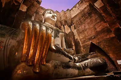
Wat Si Chum (Thai: วัดศรีชุม) has a mandapa in the middle of the complex which was built in the late 14th century by King Maha Thammaracha II. Inside the mandapa, there is an 11-metre-wide and 15-metre-high seated Buddha image called "Phra Achana", which was mentioned in Ramkhamhaeng stele. The Mandapa has a square base of 32 meters on each side and 15 meters high, and its walls are three feet thick. In the south wall there is a narrow staircase passage which can be used to reach the roof. In this passage more than 50 slates were discovered on which scenes from the Jātakas are engraved. These slates are the oldest surviving examples of Thai art of drawing. Baker and Pasuk hold that the monk Si Sattha was probably responsible for the building of Wat Si Chum, the largest monument in the city apart from the central relic stupa, and that the jataka illustrations enshrined within its walls show traces of Lankan style.
Short glosses in Thai are engraved beside the scenes. The Fine Arts Department registers them together as Sd.32, each of two to ten lines. Lucien Fournereau first published them in 1908, in a volume A. Barth edited after his death, with transcriptions and translations by the Reverend Schmitt and the Jātakas identified by Léon Feer. A Thai edition followed in 1972 and revised readings in 1985. Christian Bauer distinguishes three styles of engraving among them, and two kinds of punctuation. Their date is disputed. The late 14th century is the usual assumption, and both Vickery, from the orthography, and Prasert na Nagara, who favours a date after 1392, support a late one. Gosling argued in 1988 for the middle of the century. Bauer also reports an argument by Prasert, made at a conference in December 1991 and unpublished. On art-historical grounds Prasert held that the glosses were intended for the ceiling of the stairway rather than moved there from another monument, against the readings of Cœdès and Gosling.
East of mandapa are the ruins of vihara with column fragments and three Buddha image pedestals. North of the Mandapa are the ruins of another small vihara and another smaller mandapa with a Buddha image. The entire complex is surrounded by a moat. There is a legend that to boost morale of the ancient soldiers and people, the kings went through the hidden passageway and address the people through a hole, making them believed the voice they were hearing was actually the Buddha's.
Wat Saphan Hin
Wat Saphan Hin (Thai: วัดสะพานหิน) or Wat Taphan Hin (Thai: วัดตะพานหิน) is located on the 200 meters hill above the plain of Sukhothai. The name of the temple means Stone Bridge Monastery, since there is a slate pathway and staircase in front of the temple complex. In various stone inscriptions found in Sukhothai, this temple was also called "Wat Aranyik", and since Wat Saphan Hin and Wat Aranyik are only about 500 meters away from each other, so perhaps originally a single temple. When Ramkhamhaeng invited a learned monk from the distant Nakhon Si Thammarat in the south of present-day Thailand to become Sangharaja of Sukhothai, he built Wat Saphan Hin with beautiful vihara for Sangharaja to reside. The temple also has a large 12.5 meters tall standing Buddha image named "Phra Attharot". Another large Buddha image was found in the mid-20th century. The image has features of Dvaravati style, but more likely made in the 8th century in the kingdom of Srivijaya.
Wat Aranyik
Wat Aranyik (Thai: วัดอรัญญิก) was one of the first temple built by Tai in and around Sukhothai. The architectural remains indicate that the temple was built at beginning of the 13th century. Although the typical Khmer stonework are present everywhere. The buildings are arranged rather scattered over a relatively extensive grounds. There is a small Khmer style ordination hall on a high stone pedestal with eight Bai sema on the separate stone pedestals. Scattered on the wooded grounds are the remains of many unidentifiable stone structures possibly stupa or vihara. Normally monk residence were built from non-durable materials and are therefore no longer discernible. However, at Wat Aranyik there are some small cells made of stone, which could be perhaps once been monk residence.
Wat Chedi Ngam
Wat Chedi Ngam (Thai: วัดเจดีย์งาม) is a temple located about 2.5 kilometers west of the western city wall. The main building of Wat Chedi Ngam are aligned in east–west direction. There is a paved road leads up to the temple. The bell-shaped stupa is in Sri Lanka style which is visible from afar. Similar to Wat Chang Rop, the stupa stands on a large, square base of 24 meters on each side. On each side there is a niche which once contained a statue of Buddha. There is a slate tiles floor vihara in the east but few remains are still visible. In the north there are some structures of brick and stone that might once were monk residence. In the vicinity there is a fountain.
Wat Chedi Si Hong
Wat Chedi Si Hong (Thai: วัดเจดีย์สี่ห้อง) located about two kilometers south of the southern city gate, opposite Wat Chetuphon. The temple was built in the reign of Lithai in the late 14th century. Excavations by the Fine Arts Department in 1963 and from 1970 to 1971, the temple were restored. There is a large, bell-shaped stupa on a high, square base. Around the base of stupa are the remains of unique stucco reliefs depicting many-armed deities with flower vases, their clothing and jewelry attest to the fashion in the time of Sukhothai Kingdom. Between the deities, there are lions and elephants. The vihara is 19 × 25 meters and has rounded laterite pillars and a small porch to the east. The legs of a large seated Buddha statue can be seen at the western brick wall. A small ordination hall with remains of the boundary stones (Bai Sema) is located in the north of the temple. The base of several smaller stupas are scattered around the grounds. More stucco reliefs, which were found in the temple, are now in the Ramkhamhaeng National Museum.
Wat Chetuphon
Wat Chetuphon (Thai: วัดเชตุพล) is a temple located about two kilometers south of the southern city wall, which surrounds the historic city of Sukhothai. According to Wat Sorasak Inscription, the temple have been built before 1412 and was restored in 1970–1972 by the Fine Arts Department. A moat and a brick wall surround this temple and in the center stands a large brick mandapa, at the four outer sides they are 14th or early 15th century stucco Buddha sculptures with different postures. The eastern side depicts a walking Buddha, the northern one is sitting, the western one is standing, and the southern one is a reclining Buddha. The two large statues in the west and in the east are called "Phra Attharot". Another special feature of this temple is the use of slate in the galleries around the mandapa and the door frame. To the west, there is a slightly smaller mandapa with a Buddha image, which is called by the locals "Phra Sri Ariya" (Maitreya). Traces of black floral patterns can be identified on the walls. There is a vihara, of which only the foundations and a few fragments of columns can be seen today. About 100 meters south of the moat is an ordination hall on a slightly elevated mound and has two sets of Bai Sema.
Wat Traphang Ngoen
Wat Traphang Ngoen (Thai: วัดตระพังเงิน) means silver lake monastery. The temple was probably built in the 14th century, around the same time with Wat Mahathat. Wat Traphang Ngoen is oriented so that it is illuminated by both rising and setting sun. The main structures of the temple are a central stupa, the ruins of a vihara, a large Buddha image on a pedestal in the west and an ordination hall on an island in the middle of an artificial lake, "Traphang Ngoen" (Silver Lake). The stupa is typical 10 meters Sukhothai style in the form of a closed lotus flower stands on a square laterite base, followed by five smaller and smaller levels of brick with a plain stucco, standing Buddha image in niches in the four cardinal directions. An ordination hall lies to the east of the main stupa on a small island in the middle of the lake. In the Sukhothai time, the ordination hall was separated by a water area from the rest of the temple complex to symbolize purity. Today only foundation bricks, some fragments of columns and a pedestal on which probably used to be a Buddha image are visible.
Wat Traphang Thong
Wat Traphang Thong (Thai: วัดตระพังทอง) means golden lake monastery. The temple is located next to the Sukhothai eastern ramparts and the eastern city gate, the "Kamphaeng-Hak" gate. The temple itself is located on an island in a lake and can be reached via a pedestrian bridge from the main road. There is a typical main stupa in Sukhothai style and eight smaller stupas around the main one. A simple ordination hall was founded in 1917 by a governor of Sukhothai. The temple holds a footprint of the Buddha, which is located in a modern mandapa next to the stupa. The footprint was created in 1359 out of dark gray stone by Lithai. Wat Traphang Thong is the only temple of the historical park, in which an active community of monks lives.
Wat Tuek
Wat Tuek (Thai: วัดตึก) lies approximately 400 meters west of the O Gate (Thai: ประตูอ้อ) outside the old Sukhothai. This temple was founded in the time of Sukhothai Kingdom. In 1970 to 1971 the temple was restored by the Fine Arts Department. On the small temple grounds there is a small mandapa with a side length of eight meters contains a seated Buddha statue made of bricks that was once covered with stucco. The mandapa has three brick walls and a porch on the east side which is similar to Wat Si Chum, but is much smaller scale. There was a stucco reliefs on the outer sides, which can be seen on historical photos depicting scenes the life of Buddha. East of mandapa are the remains of a vihara with dimensions of 10 × 14 meters with some laterite pillars and a greatly dilapidated Buddha image made of laterite. The vihara is surrounded by several smaller stupa bases.
Wat Sorasak
Wat Sorasak (Thai: วัดสรศักดิ์) was founded in the time of the Kingdom of Sukhothai during the reign of Sailuethai. In 1955 a stone inscription was discovered by the Fine Arts Department and called "Wat Sorasak stone inscription" also Inscription no. 49. It is now in the Ramkhamhaeng National Museum. Because of this stone inscription, the foundation year of Wat Sorasak can be dated to 1412. Nai Inthara Sorasak, the temple founder and the author of the stone inscription was probably an officer from Ayutthaya Kingdom, sent by Intha Racha to secure the interests of Ayutthaya over Sukhothai. According to the stone inscription, there was a great stupa, vihara, a building for Buddha image in the temple complex. The Lanka style stupa was surrounded by elephants and decorated with a seated Buddha image on a square base. The stupa is reminiscent of Ramkhamhaeng's Wat Chang Lom in Si Satchanalai Historical Park. The Fine Arts Department found the remains of elephants statues and fragments of the Buddha image.
Thuriang Kilns
The Thuriang Kilns (Thai: เตาทุเรียง) are ruins of the old celadon factory, which may have been founded in the late 13th century, are situated near the city moat near Wat Phra Phai Luang. This is a site where Sukhothai celadons were made. So far, 49 kilns have been discovered in 3 different areas: 37 lie north of the moat, 9 to the south, near the city wall, and 3 to the east. The vaulted brick kilns measure 1.5 – 2 meters wide and 4.5 meters long. The ceramic wares found here are generally large bowls and jars; they have a matt yellowish grey glaze, and a design, usually of a flower, a fish, or a whirling circle, painted in black.
Saritphong Dam or Thamnop Phra Ruang
Saritphong Dam or Thamnop Phra Ruang (Thai: เขื่อนสรีดภงค์ หรือ ทำนบพระร่วง) is an ancient dam, now restored by the Irrigation Department, comprises earthenworks that stretched between Khao Phra Bat Yai Mountain and Khao Kio Ai Ma Mountain. There was a spillway and pipes to carry water across canals towards the city gates to be further reserved at the Traphang Ngoen and Traphang Thong lakes. Water from these reservoirs was used in the old city and the palace of Sukhothai.