

Dvaravati
7th to 11th-century Mon civilization
- 69 min read
- 12 chapters

Related on Lably
Through Monarchy, Polity and State (polity)
Mid-7th-century Chinese Buddhist accounts place a kingdom called To-lo-po-ti west of Isanapura, east of Sri Ksetra and north of Pan Pan. To the north it bordered Jiā Luó Shě Fú (迦逻舍佛), identified with Canasapura in the upper Mun-Chi basin and with Si Thep in the Pa Sak basin. Embassies to the Chinese court are recorded in 583, around 605–616, in 638, 640, 643, 647, and 649. Baker and Pasuk, and Murphy after Robert L. Brown, count three under that name: 638, 640 and 649.
Mon communities, perhaps including maritime traders, are thought to have carried the culture into the Chao Phraya valley by the early centuries CE. That followed the transitional Proto-Dvaravati phase associated with principalities such as Chin Lin and Tun Sun in the western plains and Tou Yuan to the east, a phase usually dated to the 1st to 5th centuries, though Stephen A. Murphy limits it to the 4th and 5th. Dvaravati's early political centre is disputed. Proposed centres include Ayojjhapura (Si Thep), Sambuka (Nakhon Pathom), and Avadhyapura (Si Mahosot). By the mid-7th century, prominence appears to have shifted to Lavo's Lavapura, following the absorption of Tou Yuan in 647. Some place the shift in the 10th or 11th centuries, with the decline of Si Thep; others take Lavapura for a separate polity, later the Lavo Kingdom, inside the Dvaravati sphere.
Its decline probably had several overlapping causes. Proposed factors are the expansion of Angkor from the lower Mekong between the 11th and 13th centuries, northward campaigns by Tambralinga under King Sujita in the mid-10th century, reported to have taken Lavo, and warfare associated with Angkor in the early 11th century that reached the Menam valley. Pagan incursions into central Thailand in the 11th and 12th centuries are also proposed. Jean Boisselier held that the eastern centres such as Lavo were lost by the 10th or 11th century, while the western principalities lasted into the early 12th century. The region then entered the Xiān period, marked by the emergence of Suphannabhum, Phrip Phri, and Ayodhya, with the latter taking control of Lavo by the 14th century.
Name
Coins and medallions
The name is known from coins inscribed in Sanskrit śrī dvāravatī, "that which has gates". They are small silver medallions found at Nakhon Pathom, Noen Hin, U Thong, and Sing Buri, with at least twenty-two further examples recorded. They bear śrī-dvāravatī-īśvara-puṇya, "merit of the glorious Lord of Dvāravatī". Their association with sanctuary foundations led Cœdès and Skilling to regard them as ritual deposits rather than currency, making their distribution an indication of the reach of a ruler's merit rather than a monetary zone. Michael Vickery cautions that -īśvara names in pre-Angkorian inscriptions have several meanings, denoting followers of Śiva, Viṣṇu, or more generally a lord or temporal ruler.
Revire lists finds from Nakhon Pathom, Ratchaburi, Suphan Buri, Sing Buri, Lop Buri and Chai Nat, but notes that most lack secure provenance, many are privately held, and forgeries have been identified. Three of the medallions were excavated under controlled conditions, at monument 7 of Khok Chang Din in 1997, inside a jar holding uninscribed ritual coins and chopped silver ingots. Two others, in private Thai collections and of uncertain origin, read śrīdvāravatīśvaradevīpuṇya, the meritorious work of the queen of the lord of Dvāravatī. Revire reads puṇya on these pieces as Brahmanical rather than Buddhist Sanskrit, in the older ritual sense of a meritorious work, and takes the lord of Dvāravatī to have counted Hindu and Buddhist foundations alike as merit.
Inscriptions
The Wat Phra Ngam Inscription (N.Th. 21), found in 2019 in Nakhon Pathom and dated to the 6th century, names three cities: Śrīyānaṁdimiriṅga or Śrīyānaṁdimiriṅgapratipura, Hastināpurī and Dvāravatī. It has been taken to suggest that Nakhon Pathom was Dvāravatī's central place. The earliest reference to Dvaravati on stone is the Wat Chanthuek Inscription (N.M. 4; K.1009) from Pak Chong, Nakhon Ratchasima Province, in Sanskrit in the Pallava script, a south Indian type now more often called Late Southern Brahmi. The inscription records that a queen who was a daughter of the Lord of Dvaravati set up a stone image of the Tathāgata. Kannika Wimonkasem and Chirapat Prapandvidya date the script to about 550–650, Claude Jacques to the sixth century.
What the stone says is read three ways. Skilling makes the queen and the daughter one person, where the first published translation made them two. Jacques read the same fragment as devī-[śr]īn and took the image to be the goddess Śrī rather than the Tathāgata, which changes what was installed and not only who installed it. Revire leaves the consequence for ritual practice open, and calls the inscription a seventh-century text. What it shows about Dvaravati's extent is disputed. John Guy takes it to carry the zone well into northeastern Thailand; Skilling argues that calling the donor the ruler's daughter places the site outside Dvaravati and marks a marriage alliance with a neighbouring realm.
Other occurrences
The name reached China in several forms, including Duheluobodi, Duoheluo, Duheluo, Duoluobodi and Tuhuoluo, where the place is described as a country (国). The records place it between Śrīkṣetra in present-day Myanmar and Īśānapura in Cambodia. Xuanzang and Yijing give Duoluobodi, which Revire suggests may represent Dvārapati, "lord of Dvāra", rather than Dvāravatī. Dvāravatī has been tentatively linked to the polity Chinese sources call Lang-chia or Lang-ya-hsiu. The name also occurs in India. The Yādava kings of Devagiri used dvāravatīpuravarādhiśvara, "overlord of Dvāravatī the best of cities", and Bhillama II described himself as lord of the city of Dvāravatī and a descendant of Viṣṇu.
Dvāravatī is the city of Krishna in Indian tradition. Sukhothai inscriptions 2 and 11 call a city probably corresponding to Nakhon Pathom nakhon phra krit, "the city of Lord Krishna"; Chris Baker and Pasuk Phongpaichit regard this as supporting the identification. Claude Jacques instead proposed Si Thep in 2009, citing its early Viṣṇu cult and two images of Kṛṣṇa Govardhanadhāra dated to about the late sixth and late seventh centuries.
The name was not confined to the central plain. The toponym is otherwise rare in Khmer epigraphy, appearing as a place name in an inscription of 952 and as a personal name in one of 1002. Revire discusses two Cambodian donative inscriptions of the late 10th and early 11th centuries that use it, but doubts that they refer to the polity in Thailand. He also notes that Thandwe in Rakhine is equated with a classical Dvāravatī in early modern Burmese chronicles.
Sign in to keep reading
11 more chapters are free with a Lably account.
History
Dvaravati culture is marked by moated urban settlements coupled with religious architecture in brick, laterite or both. Major sites include Nakhon Pathom, U Thong in present-day Suphan Buri Province, Si Thep and Khu Bua, as well as Pong Tuek and Si Mahosot.
The conventional chronology rests on Chinese texts and art-historical comparison. Excavations at Chan Sen and the Tha Muang mound at U Thong have unsettled it: newly dated Dvaravati material from U Thong may take the tradition's beginnings back to about 200 CE. Murphy accepts an earlier transitional phase but places it in the 4th and 5th centuries, holding that the sculptural and epigraphic evidence cannot be dated before the 6th and that the main period runs from the 7th to the 9th.
Proto-Dvaravati: 1st – 5th centuries
Definition and chronology
The phase is usually placed in the 1st to 5th centuries, though Murphy restricts it to the 4th and 5th. The label was proposed by Andrew Barram and Ian Glover in 2008 and taken up by Murphy, who argues that the sculpture, architecture and urban planning of Dvaravati are the end of a long process rather than its beginning. A period of local development must therefore precede them, since the older model of a wholesale arrival of Indian culture is no longer held. He prefers proto-Dvaravati to late prehistory, which implies no development beyond Iron Age forms, and to early Dvaravati, which implies a culture already formed.
Ian Glover named the interval between the two bodies of evidence the "Pre-Dvāravatī Gap". Late prehistoric finds are rich in iron and finely worked hard-stone beads; Dvaravati collections hold little iron and poorer bead work but add brick religious architecture and moated enclosures. Glover left open whether this is a break in occupation or simply sites not yet found. Radiocarbon dates on brick and plaster at Uthong have since taken occupation back to the fifth or perhaps the fourth century, on which Andrew Barram and Glover argued that the conventional range of about 600–1000 CE should move back some two centuries. Miriam Stark reported that many sites occupied between about 500 BCE and 500 CE continued in use into the Dvaravati period, particularly in the western and northern Chao Phraya basin. How much of the later religious and expressive culture began in that earlier phase she left open.
Murphy parts from Barram and Glover, who would redate the assemblage as a whole. On his reading the full range of Dvaravati pottery is not yet present in the earlier phase: kendi, a spouted water vessel, do not appear in central Thailand before the 6th century, and some prehistoric forms persist into the 4th and 5th. The same argument is applied to the polity. The embassy that reached the Tang court in 638 records the first recognition of Dvaravati rather than its beginning, since a polity had to be self-defining and wealthy enough to mount the journey.
Archaeological evidence
Archaeological evidence comes from several sites in central and northeastern Thailand. At Chan Sen, the phase dated to about 200–450 or 500 CE, formerly classified as Funan-related, is now considered closer to Dvaravati than to the Mekong delta. The sites around Chan Sen also developed from an unranked settlement pattern in 200 BCE–300 CE to a two-level hierarchy by about the 5th century. At Nakhon Pathom, Hor-Ek was occupied from the 3rd to the 11th centuries, with its earliest phase proposed as pre- or proto-Dvaravati. At U Thong, the moat and first Indic contact are placed by the mid-4th century at the latest. At Kamphaeng Saen, the first occupation dates to the fifth or sixth century, with the most intensive phase in the seventh before decline and abandonment by the ninth. Phromthin Tai near Lopburi and Kheedkhin in Saraburi show continuity from late prehistory into the Dvaravati period, but no separate proto-Dvaravati phase. In the northeast, Mueang Sema has a 4th- to 5th-century phase classified as late prehistoric, while Mueang Fa Daet has a proto-historic phase dated to about the 2nd to 6th centuries. At Si Thep, a burial group dates to 240–390 CE, while the circular moat dates to 414–602 and its eastern rectangular extension to 505–681; the excavator notes that it is unknown whether those buried there were the people who laid out the town.
The region was occupied from at least c. 1000 BCE. Between about 900 and 200 BCE the material record shows growing participation in maritime exchange, settlement continuing through the Bronze and Iron Ages; by the 1st or 2nd century CE contacts extended to South Asia, China and farther west. Finds at several sites have been linked to exchange networks tied to Funan, though the political relationship remains debated. Murphy argues that the ceramics of Nakhon Pathom indicate trade rather than Funanese overlordship. The late-BCE cemetery at Ban Don Ta Phet in Kanchanaburi adds to the evidence for these networks: iron tools and weapons, imported beads and bronze vessels, a Sa Huỳnh-type nephrite pendant, a Dong Son bronze situla, and figurines associated with Indian religious traditions.
In the eastern plain, Sup Champa (เมืองโบราณซับจำปา) in Lopburi Province points to a complex society by about 500 BCE, though its regional role is unclear. By the 5th or 6th century CE Uthong still held a central position while Nakhon Pathom grew alongside it. From the 6th to the 10th centuries Nakhon Pathom is regarded as a supra-regional center of the Dvaravati cultural sphere, alongside major centers such as Si Thep.
Origin traditions and migration narratives
The Tai Yuan Legend of Singhanavati calls the lower Menam Basin before the Dvaravati period Lava-rāṣṭra (ลวรัฐ; lit. 'land of the Lawa people'), meeting Yonok around the mouth of the Ping River. This fits Gordon Luce’s view that the Lawa once held much of central Thailand as far south as Lopburi, which rests on a supposed link between Lavapuri of the seventh-century Lavo Kingdom and the ethnonym Lawa.
The same text records continuing dealings between Tai Yuan and Lawa or Lua groups from the founding of Yonok, whose first ruler subdued several existing settlements, some of them implicitly Lawa. A Lawa princess became chief queen to the third Yonok king, and their son succeeded him.
Late in the Yonok period Chaiyasiri is said to have faced invasion by the Mon kingdom of Thaton, and in 444 CE to have led some 100,000 households south into the upper Chao Phraya basin, founding a settlement at present-day Kamphaeng Phet. No relationship has been shown between this narrative and the earliest epigraphic occurrence of the ethnonym syam, in the Funan inscription K.557 of 611 CE. From a separate tradition, the Tang Huiyao and the Cefu Yuangui record an independent polity, Duō Miè, small but populous, on the western border of Dvaravati's Tou Yuan, centred either at Lopburi or at Si Mahosot. The migration story also shaped later reconstructions of Tai-speaking movement, positing two routes, one from the northwest by way of the later Möng Mao and one from the northeast by way of Muang Then.
The same tradition has also shaped readings of the Burmese chronicle Hmannan Yazawin, which places the Gywans of Ayoja, or Arawsa, southeast of Thaton. George Cœdès identified Ayoja with Ayodhya or Siam; Francis H. Giles took the Gywans for descendants of the Tai Yuan.
Early Dvaravati: 6th–9th centuries
Pre-Dvaravati communities grew denser and larger, developing continuously into the major religious monuments of the early and middle Dvaravati period, built between roughly the first half of the 7th and the first half of the 9th centuries. The period is often described as one of competition between two supra-regional centres, Nakhon Pathom in the western valley and Si Thep in the eastern plain. After reported Chenla incursions in the 7th century, several Dvaravati polities may also have been drawn into wider conflicts.
Later traditions propose links between emerging Tai and Dvaravati centres. A 7th-century marriage between a Tai Yuan princess and the Mon prince of Lavo has been proposed, said to have produced King Sai Thong Som. The Legend of Singhanavati has Indaprasthanagara already existing under Phrom of Yonok (r. 379–438). Phrom is said to have driven the forces of a vassal of Umongasela south towards present-day Kamphaeng Phet, after which they fled to Indaprasthanagara in the Chao Phraya basin, an area the same text includes within Lava-rāṣṭra.
Rivalry among Dvaravati polities
Rivalry between regional centres such as Nakhon Pathom and Si Thep has been proposed, with later local traditions often read as reflecting it. Support for competition among the largest centres has been drawn from their moats. Eight moated settlements in the central plain were enlarged, five of them either regional centres or their nearest neighbours. Nakhon Pathom originally enclosed about 300 ha, close to Suphanburi, before later expanding to 602 ha; Phraek expanded from 81 ha to 315 ha. Mudar suggested that if these expansions were contemporaneous, the three may have been capitals of competing polities, with Nakhon Pathom's near doubling potentially marking the outcome of that competition. The expansions, however, have not been relatively dated.
The earliest narratives of conflict appear in versions of the Legend of Nakhon Chai Si and the Legend of Phra Praton Chedi. Siddhijaya is said to have come from Manohana, a name identified with Ayojjhapura in the Pali Ratanabimbavaṃsa and Jinakalamali, and in turn with Si Thep, and to have taken power in the Nakhon Pathom region about 590 CE after defeating the preceding ruler. A Dvaravati mission to China in 616 was recorded under Tou-he (投和國), with its ruler named Pu-xie-qi-yao (脯邪乞遙), which has been compared phonetically with Siddhijaya. Tradition instead has Kakabhadra holding parts of the region until 641, when his elder son Kalavarnadisharaja succeeded him, leading to the proposal that Siddhijaya and Kakabhadra may have been the same person because their supposed territories and dates overlap.
Later tradition has Brahmins from Nakhon Pathom founding Lopburi, south of Si Thep, around 629, with the city completed in 648 and Kalavarnadisharaja, son of Kakabhadra, as its first ruler. The Northern Chronicle describes his reign as expansive, politically reaching Chiang Saen and involving dynastic ties with Tai Yuan rulers. It does not describe his dealings with Si Thep, whose 6th- and 7th-century ruling line is attested by the Ban Wang Pai inscription (K.978) and later linked by the Jinakalamali to Rajadhiraj, a king of Ayojjhapura. The foundation story conflicts with the Cāmadevivaṃsa, which places Lavo under Navaratna (นพรัตน์) in 647, before Kalavarnadisharaja's supposed accession. Xuanzang likewise knew Lavo as Luó-wō-guó (罗涡国) by 629, while some sources place its foundation as early as 538.
Authority in the Menam basin appears to have been reordered after the last tribute mission attributed to Dvaravati, the Tou-he kingdom (投和國), in the Zhenguan period (貞觀, 627–649). Tatsuo Hoshino places a possible shift as early as about 665, when Pú jiā yuè mó, associated with Si Thep, is said to have brought the Si Thep and Nakhon Pathom regions under one authority. This did not last. The Jinakalamali later has Anuruddha, ruler of Arimaddanapura, often identified with Nakhon Pathom, campaign against Ayojjhapura or Si Thep and capture its ruler Manohanaraj, while the Northern Chronicle has him continue towards Indaprasthanagara in the Phraek region.
The tribute sequence had begun in 638 with an embassy arriving without Linyi, through which most South Seas missions then passed; the Cefu Yuangui notes at this first appearance that the state belonged to the Kunlun category. Missions followed in 640, 643 and 649, and in 643 and 647 embassies also came from Tuoheng, which the Jiu Tang shu calls a dependency of Dvaravati. In 649 the ruler sent ivory and fire-beads and asked for fine horses, Tuoheng having asked for horses and a bronze bell two years before. Lin Ying and Huang Jiaxin note that such requests were unusual where return gifts were normally silk; the Tang are recorded granting horses to a South Seas polity only once, to Linyi in 713. They read the asking as a mark of Dvaravati's standing among the polities by which Chinese sources located others.
Late in the 7th century, the Legend of the Arhat has Balidhiraja, eldest son of Kalavarnadisharaja of Lavo and ruler of Sukhothai, marching south, deposing the ruler of the western valley and installing his youngest son Sai Thong Som, while his elder son Balipatijaya took Lavo about 700 CE. A ruler called Padumasuriyavamsa then appears at Indaprasthanagara in the central Menam valley by 757. Later traditions give him Lavo and Sukhothai and a reach east across the Korat Plateau to Mueang Talung (เมืองตลุง or ตะลุมดอ) in present-day Prakhon Chai, and several later Siamese monarchs claimed descent from him. A separate Legend of Mueang Phaya Re gives the city's revival to King Sudarsana in the same year. An 8th-century terracotta Buddha from Uthong names King Maratha but gives no information on his polity's relation to the other centres.
In the early 9th century the Ratanabimbavaṃsa has Adītaraj of Ayojjhapura, identified with Si Thep, besiege Indaprasthanagara after the death of its great ruler. The Si Thep line remained a regional power: Bhagadatta is dated to 859 CE by the Śrī Canāśa Inscription (K.949), and the line is said to have lasted until 949, when incursions from Angkor ended it. The Nyah Kur people near Si Thep speak an archaic Mon-related language with Khmer loanwords and preserve traditions of ancestors driven into the highlands after Khmer seized their settlement. Their distribution has been linked to the expansion of Angkorian influence in the 10th–11th centuries, while Khmer ceramics and Chinese Song dynasty celadon attest activity in the highlands between the 10th and 12th centuries.
After Adītaraj's campaign, the Northern Chronicle and the Ratanabimbavamsa place Bhūpati of Vajraprākārapura, modern Kamphaeng Phet, on good terms with Ayojjhapura and Ngoenyang Chiang Rai and sending a son to rule Lavo, which had been under Indaprasthanagara since Padumasuriyavamsa's reign. The Ayutthaya Testimonies also make Vajraprākārapura a foundation of one of Padumasuriyavamsa's descendants. A few decades later the Jinakalamali and Cāmadevivaṃsa have Uchitthaka, a cakravartin, lose Lavapura to Sujita of Tambralinga in 927 and then seize Haripuñjaya, ruling there until 930. Local ruling lines in the upper, central and western regions appear to have lasted into the late 10th and 11th centuries, before pressure from Pagan, Tambralinga, Angkor, Chola and Ngoenyang Chiang Saen.
Settlement and polities of the Khorat Plateau
Dvaravati culture spread into Isan and lowland Laos from the sixth century, with major sites at Mueang Fa Daet in Kalasin Province and Sema in Nakhon Ratchasima Province. The Khorat Plateau and the middle Mekong, east of the core Dvāravatī centres, nevertheless appear to have developed outside the Dvāravatī political network as a loose landscape of small fortified and moated settlements. The region's sema stones, Buddhist boundary markers, are likewise a local tradition: Stephen Murphy argues that their use arose locally in answer to the Vinaya requirement for boundary markers, whose form it leaves unspecified.
Epigraphic and Chinese evidence points the same way, to a plateau divided among many small polities between the 6th and 9th centuries, with several inscriptions naming local rulers or nobles as religious donors. Because Mahendravarman's victory inscriptions record victories without demonstrating lasting control, Michael Vickery argued that they do not establish direct Chenla authority beyond the Dongrek Mountains, and regarded the campaigns as temporary expeditions with limited political effect, after which regional inscriptions name no ruler from the Tonlé Sap basin for several centuries. References to the plateau grow rarer from the 9th century, with Wen Dan's last recorded mission to China in 799. Hunter Watson cautions that the distribution of the plateau's Old Mon inscriptions does not by itself define Dvaravati's extent, since sites bearing such inscriptions need not have been affiliated with it.
Si Thep dominance
After Chenla fragmented in the early 8th century, Si Thep emerged as the principal regional power in the Menam basin. Chinese records place a polity called Qian Zhi Fu (千支弗) there, its first tribute to the Tang court falling about 656–661. Tatsuo Hoshino identified the Gē Luó Shě Fēn of the 8th-century sources with it, and read its sphere as reaching across much of the Chao Phraya valley while Lavo stayed within the Dvaravati network.
Hiram Woodward reaches a comparable picture from art history but places Si Thep itself within Wen Dan, and offers that only as a possibility. Si Thep's regional dominance may have ended with Rāmaññadesa's conquest by Angkor in 946.
Late Dvaravati: 9th – 11th centuries
Economic change and regional shifts
Some scholars date this phase to the 9th and 10th centuries, while others extend the Dvaravati cultural horizon into the 11th. Economic conditions in the western Menam valley changed, alongside continued trade with Tang China through Maritime Silk Road routes. Surveys around Uthong indicate low population density during this phase and abandonment by the 12th century, although trade between Mueang Uthong and the Tang continued in the 9th and 10th centuries.
The regional balance also shifted as Tambralinga expanded into the lower Menam basin in the early 10th century. Nakhon Pathom, identified with Mevilimbangam, prospered through maritime trade during the rise of Srivijaya despite limited political influence, while local traditions referred to the city as Śrīvijaya. Lavo, meanwhile, emerged as a regional centre under Angkorian influence from the 11th century.
After Tambralinga briefly took Lavo in 927, and Angkor annexed Si Thep in 949, several Dvaravati centres are described as coming under new rulers or losing their previous position. The Northern Chronicle places the Sukhothai region under Haripuñjaya house in the 950s, while the Yonok Chronicle records an attack on Suphannaphum in the 930s, after which its two princes fled north into Haripuñjaya. Tambralinga campaigns launched from Lavo against Haripuñjaya likewise failed.
Reestablishment of Indaprasthanagara
Following the fall of the first Indaprasthanagara, attributed to flooding and an incursion from Ayojjhapura at Si Thep around the mid-9th century, a noble named Sudarsana established himself at Aroccakāma (อโรชคาม) in the western valley and renamed the settlement Indaprasthanagara, according to the Northern Chronicle. Around the same period, the Ayutthaya Testimonies recount an unnamed monarch of the lineage of Phra Lue (พระลือ) who moved to occupy the vacant throne of Phra Nakhon Sawan Buri (modern Sankhaburi, also known as Phraek Si Racha). This lineage was subsequently continued by Sudhammaraja, who is said to have moved the centre of the polity to Phitsanulok around 937. Then, Sindhob Amarin, a descendant of Sudarsana of the second Indaprasthanagara, is said to have occupied Phra Nakhon Sawan Buri, where the new seat was likewise known as Indaprasthanagara. These relocations coincided with the period of the Angkorian Rajendravarman II's (r. 944–968) victory over Rāmaññadesa, potentially referring to the eastern Menam basin centred on Lopburi and Si Thep.
The Northern Chronicle puts the third Indaprasthanagara, at Phra Nakhon Sawan Buri, roughly 15 days' travel north of Ayodhya, and the second 15 days west of it.
By the mid-10th century, Lavo is said to have come under the authority of Sindhob Amarin at Indaprasthanagara, a transition associated with the tradition of Sricandradhipati, described as a commoner from Lavo who became ruler of Sukhothai in 959. After the Rāmaññadesa's conquest by Angkor in 946, Ipoia Sanne Thora Thesma Teperat is said to have moved his seat from Indaprasthanagara southwestward to Yassouttora Nacoora Louang, while the line based at Phitsanulok also moved southwestward to Phetchaburi.
Lavo under Angkor and its reversal
Following the relocations of Visnuraja around the mid to late 10th century and of Ipoia Sanne Thora Thesma Teperat around the end of the same century, Lavo is described in the inscription as deserted and overgrown with dense forest. By about 1001–1005 it had come under Angkorian rule during the reign of Suryavarman I, and Lakṣmīpativarman, a general he appointed to govern and revive Rāmanya, is said to have restored and repopulated it as the western district. Whether the same inscription records a Khmer conquest of Lavo between 1011 and 1014 is disputed: U-tain Wongsathit and his co-authors read it so, while Walailak Songsiri rejects the identification of Rāmanya with the Mon on which that reading rests. In 1052 the Angkorian ruler at Lavo was defeated by a king of Haripuñjaya, who installed his younger brother Chandrachota as a new ruler.
Mahidharapura line and the Menam polities
Events at Angkor also reshaped the northern Menam region. The Mahidharapura line of the Phimai region lost Angkor and Preah Vihear to Suryavarman I around 1010 in a succession struggle, while the rival claimant Jayavirahvarman withdrew toward Phimai, where an inscription of 1008 records his donation to the god Vimāya after the loss of Angkor. The loss of authority by the Mahidharapura elite has been interpreted by some scholars as involving their displacement into what is now upper northeastern Thailand. The line reappears in the north later in the century, when Pha Mueang, lord of Mueang Rad, received a Khmer title, regalia sword and princess in marriage from the ruler at Angkor. The princess, Sukhara Mahadevi, is associated with the court of Jayavarman VII, and the marriage has been interpreted as strengthening the role of the Tai Lueang (ไทเลือง) house.
These developments coincided with traditions of Tai movements and alliances in the upper Menam valley. The Northern Chronicle describes a coalition of Tai Yuan mueang under Śrīdharmatripiṭaka (ศรีธรรมไตรปิฎก) of Ngoenyang Chiang Saen moving south during the reign of Suvacanaraja of Chaliang, beginning around the 1050s. The conflict was settled by marriage, with Suvacanaraja giving his only daughter to Śrīdharmatripiṭaka, who is also credited with rebuilding Phitsanulok. The same tradition places Śrīdharmatripiṭaka at Phitsanulok from 1106 until his death, although scholars generally date these events later than the chronicle's stated date of about 1500 BE (957/58 CE). In the lower basin, the death of Narai of Ayodhya in 1087 without an heir is said to have led to a two-year succession war among nine royal houses, won by Phra Chao Luang.
The union of the Śrīdharmatripiṭaka and Suvacanaraja houses is said to have produced two princes, with the elder, Kesariraja, becoming ruler of Lavo around 1106. A son of Kesariraja, Duangkrian Krishnaraja (ดวงเกรียนกฤษณะราช), is said to have married an Ayodhya princess, a daughter of Phra Chao Luang (r. 1089–1111). He then moved to rule a polity named Senā Rāja Nagara (เสนาราชนคร); however, its location remains inconclusive, with some scholars identifying it with the 13th-century Mueang Rad (เมืองราด) in the narrative concerning Sri Naw Nam Thum and his son Pha Mueang of the Sukhothai.
Phitsanulok provides a geographical link between these traditions and the later history of the upper Menam. The Northern Chronicle places Śrīdharmatripiṭaka at Phitsanulok from 1106 until his death, while inscriptional evidence has been interpreted as linking the area to a Tai Lueang house traced to Sri Naw Nam Thum. From the late 12th to the mid-14th century, this house is said to have held the upper eastern Menam, particularly the lower Nan River basin around Uttaradit and Phitsanulok. The line then passed the territory to the Xiān house of Si Inthrathit under Maha Thammaracha I. The latter is said to have moved the capital from Sukhothai to Phitsanulok in 1349.
Middle Mekong network and Angkorian influence
The middle Mekong and Khorat Plateau formed a transitional zone between the Dvāravatī sphere and the pre-Angkorian polities. The Urangkhathat (ตำนานอุรังคธาตุ), the foundation legend of Phra That Phanom, preserves a network of interconnected polities rather than a unified kingdom. Its political geography has been dated to the 10th century and later, chiefly from the earliest architectural phase of Phra That Phanom, which predates later Lao and Isan renovations. The legend of Phadaeng Nang Ai gives a more localized account of political organization, centred on the Nong Han–Sakon Nakhon area also named in the Urangkhathat.
Within this network, the Urangkhathat gives particular prominence to Saket Nakhon Roi Et Pratu (สาเกตุนครร้อยเอ็ดประตู; lit. 'Saket, city of a hundred-and-one gates'), which it places on a level with Yothika (โยธิกา), Kurunta (กุรุนทะ), or Ayodhya in the Menam Valley. Its ruler, Phaya Suriyawongsa Sitthidet, is described as exercising ritual overlordship over subordinate polities whose rulers presented gold and silver flowers each year. The name Roi Et, meaning a hundred and one, is generally understood as a symbol of pre-eminence rather than a literal number of dependent towns. Saket, an Indian toponym associated with Ayodhya in Hindu, Buddhist and Jain traditions, appears to function as borrowed sacred geography legitimising regional kingship rather than as evidence of direct contact with India.
From the 9th century, the Nong Han region and the Chi–Mun basins came increasingly within the Angkorian sphere. Angkorian influence overlaid rather than immediately replaced the existing Dvāravatī landscape, producing a mixed Dvāravatī and Khmer material culture, while inscriptions from Mueang Sema still placed the polity outside "Kambujadesa", Angkor proper. Integration continued through the 10th and 11th centuries, including under Jayavarman V (r. 968–1001), whose court brahmin Yajñavaraha founded religious establishments at Mueang Sema, and Suryavarman I (r. 1002–1050), when Prasat Preah Vihear was built on the Dângrêk escarpment above the region. By contrast with the network of semi-autonomous centres preserved in middle Mekong traditions, the southern Mun basin was progressively incorporated into the Angkorian state.
Pagan expansion and final decline
The 1056 Gywan incursion has been taken to mark Anawrahta of the Pagan Kingdom extending his authority into the lower Menam basin. The Hmannan Yazawin records the Gywans of Ayoja attacking the Mon centre at Thaton in that year, during Pagan's annexation of it; Burmese inscriptions from the Arakan Pagoda in Mandalay are read as corroborating the episode, and the Thaton chronicles record an attack by the Krom, both ethnonyms probably standing for the Khom people. Nakhon Pathom may have been destroyed about 1058 and Lavo submitted. Several urban centres may have been destroyed, while Nakhon Pathom lost most of its population between the 11th and 12th centuries. It had already been weakened by the wars between Haripuñjaya and Lavo in the early 10th century and was reportedly raided in the late 1020s or early 1030s during the Southeast Asian campaign of the Chola ruler Rajendra I.
The Northern Chronicle records the Pagan noble Kar Tayy exercising political authority over the Suphannaphum–Uthong region from about 1081 to 1121, after which Mueang Uthong was abandoned and Suphannaphum was recorded as being left without a ruler. The chronicle also recounts a Pagan invasion of the newly refounded Ayodhya in 1087. Although Ayodhya prevailed, its ruler, Narai I, died that year.
Around the same period, the Legend of Nakhon Si Thammarat describes Sri Dharmasokaraja I as a ruler from Pagan's Hanthawaddy who governed Indaprasthanagara–Lavo in the east-central Menam valley until about 1117, before moving south to Nakhon Si Thammarat. He is also identified with Narapati (พญานรบดี), a name found in the Jinakalamali, which identifies him as the king of Suphannaphum and father of King Āditya (อาทิตย์) of Chanabotwichet (ชนบทวิเชต), probably modern Mueang Tak, in Syampradesh. The Jinakalamali treats Chanabotwichet as a separate country from Suphannaphum, and linking this ruling line to northern Thai polities through Buddhist connections. During this period of Sri Dharmasokaraja I's dominance, the Ayutthaya Testimonies recount that Surindraraja, the Xian monarch at Phraek Si Racha, moved his seat northward to Chai Nat, probably identified with Phitsanulok, which had previously served as the seat of his predecessor since the early 10th century.
These accounts have been taken to indicate roughly a century of Pagan penetration into the Menam valley, consistent with the early 13th-century Zhu Fan Zhi, which places Pagan on Chenla's western border. After Sri Dharmasokaraja I moved south, Angkor recovered Lavo and again expanded influence into the Menam basin. This may correspond to the Banteay Chhmar Inscription, in which Jayavarman VII and his son march against an invasion from the west, and the Prasat Tor Inscription, in which he defeats the monarch of the west in 1189/90 or 1195/96. Baker and Pasuk read the Banteay Chhmar text more narrowly: it records Jayavarman VII and his son resisting an army from the west without specifying how far west it came, and therefore does not establish the extent of Angkorian expansion.
Post-Dvaravati: 12th – 13th centuries
Regional transformation
The 12th and 13th centuries saw fragmentation and competition among new centres in the Menam and Mae Klong River basins, several of which became the attested Siamese states of Phrip Phri, Suphannaphum, Suvarnapura, Sukhothai and Ayutthaya. Older centres declined. Si Thep remained under Angkorian authority but declined politically and economically and is generally held to have been abandoned by about the 13th century. Nakhon Pathom and Khu Bua also appear to have lost population, while power shifted towards the Mae Klong basin, including modern Ratchaburi and Mueang Sa Kosi Narai (เมืองสระโกสินารายณ์). These have been identified with Jaya Rajapuri and Sambukapattana in the Preah Khan Inscription (K.904), and both show clear Angkorian cultural influence, as does nearby Pong Tuek.
The principal western Menam centre appears to have been Mueang Sing, while the eastern plain was centred on Lopburi, which alternated between Angkorian control and local autonomy. The Preah Khan Inscription names them Sri Jayasimhapuri and Lavodayapura. The extent of Angkorian authority over the Menam valleys under Jayavarman VII remains debated. The hospitals (arogyasala) and fire houses (vahnigrha) along the roads from Angkor reach no further west than Prachin Buri, while the dispatch of Jayabuddhamahanatha to at least six Menam polities may instead represent cultural diplomacy. Baker and Pasuk find little evidence of direct administration: Angkorian records describe campaigns east but only one ambiguous western one, the Banteay Chhmar text; the Menam plain lacks the temple-endowment inscriptions and Khmer official titles usual in Angkorian provinces; and no resource transfers from the plain are documented. Srisakra Vallibhotama likewise has local rulers adopting Angkorian political and ritual forms selectively rather than coming under direct administration.
Mueang Sing illustrates this selective interaction. Its architecture closely follows the Bayon style of Jayavarman VII's reign, but archaeologists suggest that the master craftsmen may have come from Angkor or Lavodayapura, while much of the work was local. Its irregular construction and sandstone bases bearing Late Angkorian script and language suggest that some parts may have been completed or altered after Jayavarman VII's reign. Excavation has yielded only a small amount of Ming Chinese ceramic alongside Sukhothai wares, providing little evidence for sustained occupation after the Angkorian period.
Lavo's relationship with Angkor also appears to have been flexible. One interpretation places Lavo under Angkorian control throughout the period, with independent missions to China during Angkorian succession disputes and independence before 1289. Baker and Pasuk instead point to evidence of local autonomy: in Suryavarman II's procession at Angkor Wat, Jayasinhavarman of Lavo appears prominently with his troops; Suryavarman II patronised Buddhism at Lopburi; and Lopburi rulers maintained marriage ties with both Pagan and Angkor.
Chinese merchants recorded several polities between 1103 and 1115, including Zhēn Lǐ Fù, Róng Lǐ, Luó Hú, and Xún Fān, some tentatively located in the lower Menam basin. Conflicts among them are possible during this transitional phase.
Epigraphy also points to growing linguistic diversity in the lower Menam basin. Thai lexical items occur in inscriptions otherwise written in Pali, Sanskrit and Old Khmer, including K.766 of 1167, K.995 of 1213, and the Mueang Sing inscription (กจ. 4), tentatively dated to the 13th or 14th century. Their scripts differ markedly from those in the Phimai, Surin, Buriram and Angkor regions within Jayavarman VII's sphere. The latest records the local ruler Phraya Chaiyakon (พฺรญาไชยกร). Comparable linguistic evidence appears in the Phra Aiyakan Betset, an original section of the pre-Ayutthaya legal manuscript with an internal date corresponding to 1224 CE, written entirely in Thai and displaying archaic features and phraseology reminiscent of the Sukhothai Ram Khamhaeng Inscription.
Emergence of Siamese polities
Later traditions and epigraphy describe several regional ruling lines in the Menam valley during the 12th century. Readings of the Dong Mè Nang Mưo'ng Inscription (K.766) have Sri Dharmasokaraja II recover Lavo in 1157 and extend his authority north towards present-day Nakhon Sawan. Other traditions place rulers at Mueang Sing, Kamphaeng Phet and Suphannaphum moving north and returning, one line expanding northward into alliance with Tai chiefdoms. The Nakhon Si Thammarat Chronicle has Sri Dharmasokaraja withdraw south in the 1190s, after the riverine powers had recovered these territories.
To the east, the Angkorian succession contest that ended in Suryavarman I's victory in 1010 is said to have forced the Mahidharapura line northward, in one proposal as far as present-day Sakon Nakhon. That line married into a Tai Lueang house, and the marriages have been read as connecting Pha Mueang and Si Intharathit to the northern Xiān polity of the Menam basin. Chronicle traditions record Tai campaigns against Ngoenyang in the 1150s and political fragmentation on the Korat Plateau after them. By 1219 the Tai Lueang polity is said to have held Chaliang and Sukhothai, and an intervention by allied Tai Lueang and Xiān forces in 1238 has been treated in later reconstructions of early Thai history as formative for the Sukhothai Kingdom.
Formation of Ayodhya
Angkorian authority is said to have been reasserted in the region in the 1180s and 1190s, the Prasat Tor Inscription recording that Jayavarman VII defeated a "monarch of the west" in either 1189/90 or 1195/96. Chinese sources of the same period describe the central Menam valley as held by its former ruling line under Pra Poa Noome Thele Seri and known as Chen Li Fu, broadly associated with Indaprasthanagara in the Phraek region and possibly surviving into the 13th century. The Ayutthaya Testimonies place its dynasty in the same lineage as the early Sukhothai rulers, while Walailak Songsiri suggests that the Indic name of the Chen Li Fu ruler may have been adopted as a formal title for relations with China.
In 1205 a southern Siamese lineage is said to have taken the throne in the lower western valley through royal intermarriage, under Uthong II; Ayodhya became the seat later in his reign, and the polity was identified as Xiān in several Chinese and Đại Việt sources. A prince of the same lineage ascended the Ayodhya throne as Ramathibodi I in 1341 and strengthened his position through marriage alliances with Lavo to the east and the Tai–Siamese Suphannaphum to the west. The former Dvaravati principalities had been incorporated into the Ayutthaya Kingdom by 1438.
Pre-Lan Xang political networks in the Korat Plateau
With the Dvaravati and Angkorian networks in decline, the Khorat Plateau became a frontier in the late 13th and early 14th centuries where three spheres overlapped. These were the declining authority of Angkor over its Mahidharapura- and Sakon Nakhon-linked networks, the expanding Siamese kingdoms of Sukhothai and later Ayutthaya, and the Lao mueang of the middle Mekong, united by Fa Ngum as Lan Xang in 1353. Direct epigraphic and archaeological evidence is thin, so the political geography is reconstructed largely from later chronicles, retrospective place names, and comparison with Angkorian and early Lao sources, leaving many identifications provisional. Archaeology gives a different picture. Surveys of early Lan Xang settlement centre on the Loei–Nong Bua Lam Phu–Udon Thani–Nong Khai corridor, where securely dated sites lie west of the Phu Phan Range, and have been interpreted as a frontier network associated with Fa Ngum's reign along the Phetchabun and Phu Phan corridors. This leaves much of the central plateau outside the initial archaeological network, in contrast to chronicle identifications that place several conquered mueang around Phimai. Most inscriptions from the region date only from the later Vientiane period, leaving the two reconstructions unreconciled.
Relations with neighbouring polities
Dvaravati–Chenla relations
Dvaravati polities of the Chao Phraya basin have been held to have maintained dynastic ties with those of the Tonlé Sap basin and the Mekong Delta since the Funan period. Cœdès identified Chakravartin, the father of Prathivindravarman of Si Thep in the Wang Pai Inscription (K.978), with Rudravarman, the last ruler of Funan's Candravaṃśa line. Claude Jacques instead identified him with Mahārājādhirāja Śrī Devanika, whom the early 5th-century Devanika Inscription (K.365) describes as coming from a distant land. On this reading, Devanika ruled from Si Thep and sent princes to settlements along the trans-Mekong trade route, including Vat Phou, whose ruling line was later associated with Chenla. Zakharova disputes the identification.
Cœdès and Jacques initially dated the Wang Pai Inscription to the mid-6th century and identified its Bhavavarman with Bhavavarman I of Chenla, though Jacques later read it as a local ruler of Si Thep. Kangwon Katchima dates it after 637 on epigraphic grounds and identifies Bhavavarman II or another local ruler, whose authority may have reached no further than south of the Dângrêk Mountains. Anurak Depimai rules out Bhavavarman II, since the Wat Kud Tae Inscription makes him a son of Isanavarman I.
Under Isanavarman I of Chenla (r. 616–637), Chenla sought to extend its influence into the Menam Basin, particularly toward Tou Yuan, whose main centre has been proposed as either modern Lopburi or Si Mahosot. A Chao Phraya valley fable links the conflict to a marriage between a Chenla princess and a Dvaravati ruler. Michael Vickery separately proposed that Harshavarman, who claimed descent from Isanavarman and later ruled Uthong, headed a branch of the Chenla royal house centred in central or eastern Thailand, with links to Cham royalty; the Copper Plate Inscription records the descent but not the proposed marriage.
Karen Mudar instead read the plate through the settlement hierarchy: U Thong's 73.3 ha moated area was a district centre, which she suggested may mark lost autonomy rather than a royal court. Revire cautions against dating the plate from a single letter form: the short medial vertical of its ka, often read as post-Pallava and so later than the seventh or eighth century, also occurs in dated seventh-century inscriptions from southern Cambodia, including K. 79 (644 CE), K. 50 and K. 582 (667 CE). He treats it as a possible regional variety, and notes that inscribed copper sheets, common in India and Indonesia but unknown in Cambodia, may raise the possibility that the plate reached U Thong from elsewhere.
Under Isanavarman I, Chenla also established marriage ties with Champa and Dvaravati-sphere polities such as Zhu Jiang and Can Ban. The western Menam basin likewise shows artistic influences from both Chenla and Champa. Dvaravati also formed a dynastic connection with a polity in the upper Mun Basin through the marriage of a princess to its ruler, recorded in the Wat Chanthuek Inscription (K.1009); Skilling suggested, without deciding, that this polity may have been Cānāśa.
After Isanavarman I's death, his successor Bhavavarman II (r. 639–657) appears in the Wat Kud Tae Inscription at war with Dvaravati Sambuka, commonly identified with modern Nakhon Pathom. Chaowanee Lekkla, however, gives Śambūka only as the name of his adversary's town and does not locate it. Tatsuo Hoshino argued that the conflict involved several polities, including Qiān Zhī Fú (later Gē Luó Shě Fēn), Xiū Luó Fēn and Gān Bì. Tou Yuan, previously targeted by Chenla expansion, was recorded in 647 as a vassal of Dvaravati, while Kalavarnadisharaja (r. 641–700) of Dvaravati Nakhon Pathom founded or refounded the Lavo Kingdom in 648.
Jyesthapura, identified with Mueang Phai and the area around Prasat Kao Noi, served as the seat of Bhavavarman II from 637 to 639 before he moved toward the lower Tonlé Sap region. The Khao Noi inscription (K.506), dated 637, names Isvarakumara as svāmi of Jyesthapura, while the Wat Kud Tae inscription (K.1150) names Sivadatta, a son of Isanavarman I and elder brother of Bhavavarman II, in the same office. During this period, Dvaravati polities in the western Menam Basin extended their influence eastward to the same frontier zone around Mueang Phai and Prasat Khao Noi. This period of close contact between Dvaravati and Chenla, involving both alliances and conflict, also coincides with pre-Angkorian references to syam as a toponym or ethnonym in K.557 (611 CE), K.79 (639), K.127 (683), K.154 (685) and K.904 (713), including references to enslaved persons and a landholding official. These references disappear after Chenla fragmented in the early 8th century.
Dvaravati and Wen Dan
In the same period, the region northwest of the Tonlé Sap, south of the Dângrêk Mountains and around present-day Battambang Province, is described as having divided into four polities that sent their own embassies to China after breaking away from Chenla. By the 720s, the region appears to have fallen within the sphere of Wen Dan, a polity associated with Dvaravati. Buddhist boundary stones (Bai sema) on Mount Kulen were first proposed as 8th-century Wen Dan foundations, but the argument was withdrawn because they cannot be dated closely enough against Jayavarman II's accession in 802. The case rests instead on the scarcity of inscriptions and the halt in monumental construction around Angkor from about the 720s. On this basis, Hiram W. Woodward proposed that the northern Tonlé Sap region was no longer under Lower Chenla but within the sphere of Wen Dan, which maintained close relations with, or exercised authority over, Si Thep. Population movements from the region toward Si Thep in the early 8th century have likewise been associated with Wen Dan.
The Tonlé Sap polities were reunified in the early 9th century, when their principal centre shifted north toward the Angkor region. Jayavarman II (r. 780–850), a ruler of Lower Chenla later regarded as the founder of the Angkorian monarchy, is recorded as renewing relations with the Mun–Chi basins, where the former ally Zhu Jiang lay, and meeting Dvaravati Si Thep in the Menam–Pa Sak valleys. Woodward further proposed that Jayavarman II defeated Wen Dan, after which the remaining Dvaravati-associated region in the Chi valley entered the Javā era. Archaeological and textual evidence, however, suggests that Dvaravati's political predominance was already declining by the early 8th century.
Angkorian expansion into former Dvaravati territories resumed in the 10th century. Under Rajendravarman II (r. 944–968), Angkor took Si Thep in 946, after which the city declined and was abandoned by about the 13th century, as Sukhothai and Ayutthaya rose. Lavapura of Lavo came under Angkorian influence from the 10th century and under Angkorian authority in 1005, under Suryavarman I (r. 1002–1050). He also recovered polities lost to Dvaravati since the 8th century, including Jyesthapura in present-day Sa Kaeo Province and Candhrapura in Chanthaburi Province, and took the former Dvaravati vassal Avadhyapura in Prachin Buri Province.
Dvaravati–Champa relations
Contact between the Dvāravatī sphere and Champa is attested chiefly through art and architecture. Varis Domethong divides it into two phases with different geographies. Between roughly the sixth and ninth centuries, the Thai material clusters in the Tha Chin and Mae Klong basins, with U Thong, ancient Nakhon Pathom and Khu Bua as the main sites; Si Mahosot is the eastern outlier. From about the ninth century, the western evidence thins and the eastern evidence disappears, while comparable material appears in the northeast at Mueang Fa Daet and Phra That Phanom. On the Cham side, the distribution likewise contracts from a broad area to the Quảng Nam sites of Dong Duong, Tra Kieu and My Son. Domethong considers this distribution preliminary because access to Cham material in Vietnam is restricted.
The earlier phase is represented mainly by Brahmanical material. A kośa recorded on the U Thong copper plate corresponds to a rite attested at My Son in 687, while Dvāravatī figures of dancers and musicians have been compared with the My Son E1 pedestal.
The later phase is Buddhist and concentrated in the northeast. At Phra That Phanom, Domethong compares the earliest building phase with the Dong Duong style of Champa and dates it to the early tenth century, following the transfer of the Cham capital to Indrapura in 875. He also points to Cham-style brickwork and reliefs comparable to those at Dong Duong. At Mueang Fa Daet, similarities occur in the sema stones and a lion sculpture. Murphy has argued that one distinctive seated figure type occurs in northeastern Thailand and central Champa, suggesting movement of craftsmen between the two regions. The Fa Daet lion also follows a type known from Tra Kieu, though Domethong considers it a local interpretation.
Domethong interprets the shift as reflecting political and religious change in Champa after 875, but not Cham political control in northeastern Thailand. He follows Phasook Indrawooth in treating Fa Daet Song Yang as an independent polity and the Cham material there as evidence of cultural relations between neighbouring centres.
Settlement pattern
Distribution
The moated towns of the plain developed from a much wider Iron Age settlement. Baker and Pasuk report over 1,500 Iron Age sites on the Isan plateau, where survey has been most intensive, some large enough for over 2,000 people. In the Chao Phraya plain, sites cluster around the copper-working district at Lopburi, the lower Pasak valley, the Mae Klong and Bang Pakong, and farther north along the Ping and Yom. Increased burials at the Lopburi sites are read as population growth. A distinctive form of moated mound appeared in the same period, which Baker and Pasuk suggest may have begun as natural landforms modified with concentric moats, the water serving mainly as a secure domestic supply rather than for irrigation.
The distribution of the moated towns was long interpreted as evidence for a higher sea level. A survey by Phōngsi Wanasin and Thiwa Supcanya found settlements in two rows above the 3.5-metre contour, running west from Phetchaburi through Ratchaburi to Suphanburi and east from Chainat through Singburi to Lopburi, which Wyatt read as the fringes of a plain then largely under water. Baker and Pasuk hold that later palaeo-shoreline work overturns that view. Trongjai Hutangkura, using pollen sequences and recalibrated radiocarbon dates from eight cores, dates the earlier coastline to the Holocene maximum transgression of about 6,500–6,400 BCE and the last mangrove stand in northern Bangkok to about 700 BCE–100 CE, which makes a first-millennium CE gulf head far north of the present city unlikely. He attributes the absence of Dvaravati towns from the lower plain to seasonal flooding instead, the river levees being too low to escape it. The site of modern Ayutthaya before the 9th or 10th century is described as low-lying swamp flooded each monsoon to about four metres above the dry-season level, making permanent settlement there unlikely. Murphy holds that Mudar's analysis of the moated settlements is unaffected by the coastline's position.
Archaeological survey has identified 107 Dvaravati-associated urban sites in present-day Thailand, most in the central plain. A 1998 Fine Arts Department survey gives the same total: about seventy in the central plain and east, some thirty in the northeast, and one or two each in the north and south. Other counts vary with the criteria, Phasook Indrawooth recording over thirty, Matthew Gallon almost fifty and Mudar sixty-three from Thiva Supajanya and Vanasin's inventory. Most remain poorly investigated, while Murphy identifies eight with sustained archaeological research. The largest settlements were at Nakhon Pathom, Suphanburi, and Phraek, with secondary centres at U Thong, Chansen, Khu Bua, Pong Tuek, Mueang Phra Rot, Lopburi, Si Mahosot, Kamphaeng Saen, Dong Lakhon, U-Taphao, Ban Khu Mueang, and Si Thep.
Geophysical work and the distribution of early cities have been used to distinguish three zones that may have operated relatively independently within the pre-Angkorian network. Earlier proposals divided the area into two, three or four, while Revire doubts that such divisions apply to religious art and practice.
In the north, Stephen Murphy and Pimchanok Pongkasetkan group Kamphaeng Phet, Phichit, Phitsanulok, Nakhon Sawan and upper Chai Nat as the Upper Chao Phraya basin. Sites include U-Ta Pao in Manorom, Chai Nat; Khok Mai Den, Muang Bon, Thap Chumpon, Chan Sen and Dong Mae Nang Muang in Nakhon Sawan; and Khao Kalon in Kamphaeng Phet. They regard the lower Ping, Yom, Nan and Chao Phraya as the routes of circulation through the area.
Town plans and settlement hierarchy
The towns took several forms. U Thong followed a river bend in a conch-shell shape, a plan also at Mueang Phra Rot and Si Mahosot, each with satellite settlements around it. Nakhon Pathom, the largest, had a moat, canals and more than a hundred buildings on brick bases; its major religious monuments stood outside the wall, read as a division between town-dwelling and forest-dwelling monks. The brick of U Thong and of Mueang Fa Daet Song Yang is of much the same size, was tempered at both with rice chaff or husk ash, and matches experimental brick fired at 1,000–1,200 °C. Their clays came from different settings, a still lake at Fa Daet and a fast river at U Thong, and the U Thong brick is the stronger, though neither sample has an excavated context.
Karen Mudar's study of 63 moated settlements mapped from aerial photographs grouped them into four levels by size and location: Nakhon Pathom at the top, followed by seven regional centres, fifteen district centres and thirty-four smaller sites. Boundaries midway between the regional centres produced seven territories averaging about 3,300 km², with seven to fourteen moated settlements each and centres about 75 km apart. Size did not consistently determine rank: only five of the ten largest sites were regional centres. Mudar treated a moat as evidence of labour mobilisation for public works and some supervisory role, noting that her rankings used one variable only and could change with systematic recording of ramparts and public buildings. Comparing the plain with early Korea, Andrew Logie reads the moats as possibly clearer evidence for fortified sites than anything available for Pre-Angkor or southeastern Korea. He finds less sign of a warfare culture than in either region, inferring its relative absence partly from the continued autonomy of the centres.
The settlements' rank-size distribution approximates a straight line, which Mudar read as an integrated economic system in which Nakhon Pathom neither suppressed other centres nor drew resources from a larger external system. She left the political form open: the same pattern could represent a single state, competing states, or non-state formations such as complex chiefdoms, possibly at different times. The seven territories also fit Renfrew's definition of peer polities, being similar in size and sharing writing, belief, language and institutions.
The east and the Khorat Plateau
East of the bay, Patcharaporn Ngernkerd and colleagues classified fifteen moated sites between Prachin Buri and Trat into three ranks, corresponding to Mudar's regional, district and sub-district levels. Four central towns at Si Mahosot, Mueang Phra Rot in Chon Buri, Mueang Phaniet in Chanthaburi and Mueang Phai in Sa Kaeo range from 1.06 to 2.41 km² and head three towns and eight villages. Settlement density peaks at Si Mahosot and rises again around Mueang Phai, with a sparsely settled belt between them. Ngernkerd and colleagues interpret this as a boundary between the Dvaravati and Khmer spheres, shifting westward from the early 11th century. They also propose that the western half formed a polity of its own, developing between the 5th and 7th centuries and serving as a buffer between Dvaravati and the Khmer kingdoms in the 7th–9th centuries, on locally distinctive forms (laterite ponds, Buddhist images and a Gaṇeśa) rather than epigraphy. They compare it with Stephen Murphy's treatment of the northeastern sema tradition as a regional tradition in its own right.
All Dvaravati inscriptions recovered in eastern Thailand come from the west of the region, and Nicolas Revire dates them to the 8th and 9th centuries on linguistic, script and stylistic grounds. Sanskrit inscriptions from the east instead record royal orders and a king-centred structure, which Ngernkerd and colleagues read as a different polity. Three intermediate towns, Khu Muang, Phraya Re and Muang Phrao, range from 0.52 to 0.70 km² and have circular plans with irregular extensions read as successive moat phases. Eastern villages generally have a single moat and rampart, unlike the multiple moats of sites on the Khorat Plateau. Inland settlement also existed: Khok Sam Phan was occupied from the 3rd to the 7th centuries.
Settlement-pattern studies of the upper Chi–Mun basins before the 14th century likewise find several interconnected kingdoms, linked by trade and organised around supra-regional centres such as Dong Mueang Aem, Phimai, Mueang Fa Daet, Mueang Sema, Non Mueang and Si Thep, a pattern comparable to the Menam valley. A 2015 analysis of pre-600 CE circular moated settlements in the Mun valley identified five clusters. They are a small western group at Mueang Sema; a larger Phimai group; a Phayakkhaphum Phisai–Nadun–Kaset Wisai group on the northern Mun watershed; a Buriram–Surin group; and an eastern group on the Mun–Chi watershed, densest around Suwannaphum, Phon Sai and Nong Hi.
Polities and centres
Which site held the political centre is disputed. Nakhon Pathom and U Thong are the two most often proposed; on Karen Mudar's settlement hierarchy U Thong ranks as a district centre, which tempers earlier arguments that it was the capital.
Thai scholarship adds Si Thep and Lopburi, weighing the four on position, town size, religious monuments, artefacts and outside contact. Damrong Rajanubhab argued for Nakhon Pathom from the number and antiquity of its Buddhist stupas, above all the Phra Pathom Chedi. Phasook Indrawooth placed the early capital at U Thong between about the fourth and the eighth century, holding it older than ancient Nakhon Pathom and Khu Bua. Piriya Krairiksh proposed Si Thep in 2023, on the ground that Dvaravati was principally Brahmanical where Nakhon Pathom and U Thong were Buddhist. Phiset Chiajanpong proposed Lopburi, on its Dvaravati remains and on the tradition, in Sukhothai inscription 2 and the Royal Autograph Chronicle, that relics were gathered there. Sakchai Saisingha objects to the usual test: the inscribed silver medallions are small and occur across the culture’s sites, so their number at any one town cannot fix the centre.
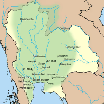
The following shows the polities under Dvaravati culture in the Menam and the Chi-Mun Valleys during the first millennium.
Government
Political form
Little is known of Dvaravati's administrative structure. It appears to have been a loose aggregation of chiefdoms rather than a centralized state, reaching from the coast of the upper Malay Peninsula into the riverine plains of the Chao Phraya. For Murphy, Proto-Dvaravati denotes a proto-state more developed than an Iron Age chiefdom or kinship-based society but without the centralized control of economic, social and religious activity that defines a state. From Mudar's settlement hierarchy he finds no centralized Dvaravati state before at least the 7th century, and probably later, seeing the 4th- to 6th-century sites as interacting while developing largely independently; only from the 7th century do inscriptions naming kings and a settlement hierarchy point towards greater centralization.
Pinna Indorf classifies carved stone wheels by base ornament and rim pattern and reads the resulting groups as lineages rather than a single ruling house, suggesting a Dvaravati zone contested by at least two groups. Matthew Gallon argues from the siting of Buddhist monuments, most outside the enclosures, that monastic and political authority may have formed separate but interdependent hierarchies. Both remain proposals, and Gallon describes his proposed arrangement as alleged.
Chinese accounts
Chinese sources from the Tang describe the polity they call Touhe, identified by some scholars with Dvaravati, as divided into three administrative tiers, commonly rendered as prefectures, counties and districts, each city reportedly having a citadel and enclosing walls. The identification of Touhe with Dvaravati is disputed: Baker and Pasuk, following Tatsurō Yamamoto, place it more likely in the archipelago. The early 7th-century Tongdian records six markets or trading centres, commonly identified with Nakhon Pathom, Chansen, U Thong, Khu Bua, Si Mahosot and Dong Lakhon, though Lopburi and Pong Tuek have also been proposed. The sources also describe numerous civil and military officials, and name Tou Yuan and Tanling as dependencies of Dvaravati. Tanling has been tentatively placed on an island or small peninsula in the marshlands of the early historic Bay of Bangkok.
The ruler is described as governing several cities indirectly, the walled enclosure holding the palace and offices while about ten thousand households lived outside it by farming and trade. The Tongdian identifies the ruler of Touhe as Touheluo, with the personal name Puyeqiyao, and records an earlier king, Qizhangmo, who bore no surname. Both are associated by later scholars with Kamalanka's Nakhon Pathom, while the last recorded Touhe embassy, in 649, is attributed to Pu-xie-qi-yao. The king is described with gold and jewelled regalia and a gilded hall, and an embassy carried a letter on gold leaf with local products.
The same account describes a hierarchy of offices: a Chaoqing jiangjun directed state affairs while other civil and military officials administered the province, prefecture and county levels, each appointing his own subordinates. It also records graded punishments, contributions according to means rather than a fixed rate, and fewer than a thousand horses in the territory, horses and elephants both being ridden.
Baker and Pasuk argue that the material record implies weaker royal authority than the Chinese notice. Dvaravati inscriptions are few compared with the Khmer corpus and mostly vernacular, while many were commissioned by commoners, suggesting that writing was not a royal monopoly. Coins and medallions bear religious and prosperity symbols rather than royal ones, especially the conch, pot of plenty and śrīvatsa. The largest known sculptural undertaking, the carved laterite wall of a water tank at Si Mahosot, depicts animals rather than gods or kings. Baker and Pasuk therefore follow Srisakra Vallibhotama in proposing several loose confederations along different river courses. Oliver Wolters likewise rejected the concept of a state for Dvāravatī and other early political systems in the region, while Revire notes that rulers cannot always be shown to have commissioned the art attributed to them or even to have been Buddhists.
People
Language and ethnicity
Dvāravatī culture is conventionally associated with Mon-speaking communities, but most scholars regard its population as ethnically and linguistically mixed. Skilling argues that its principalities held several cultural groups, people of Malay and Khmer background alongside Mon speakers, rather than a homogeneous "Mon" polity, while Charles Keyes cautions against applying such labels uniformly to a diverse region. David K. Wyatt proposed calling the Central Plain population Siamese, explicitly not as a synonym for Thai but as an ethnicity in formation.
Donative and dedicatory inscriptions likewise point to linguistic diversity, in Old Mon, Old Khmer, Sanskrit and Pāli, sometimes within one text. Hunter Watson, who has recorded more than a hundred Old Mon inscriptions in Thailand, notes that sites central to Dvāravatī have yielded few against the larger Old Khmer corpus: one from Nakhon Pathom, a clay tablet from U Thong and a cave inscription near Khu Bua. He therefore suggests that Old Mon may have served a ruling or monastic community rather than as the general vernacular. A similar caution applies to ethnic attribution in the northeast. Hiram Woodward accepts Tatsuo Hoshino's placement of Wen Dan's two capitals in the Chi basin but regards Hoshino's identification of their population as Tai-speaking as tendentious, arguing that it should neither support nor invalidate the geographical proposal.
Yurayong and colleagues date the common adoption of South Indian Brāhmī to the fifth and sixth centuries, from a mapping of 777 inscriptions of the third century BCE to the ninth century CE. Distinct regional forms develop out of it in the seventh and eighth, Old Mon among them, and these have no counterpart in South Asia. The same study suggests that the phonological type shared across the central and southern mainland may have formed in the Dvāravatī period and persisted under later Thai dominance.
Mathias Jenny dates the first Mon inscriptions of the plain to the sixth century and describes them as texts short enough to fix the language but not its structure, after which Mon documents are almost absent for several centuries. He treats Mon as the uncontested literary language of the region until Khmer and Tai speakers arrived around the eleventh century, and notes that next to no Mon documents survive in Thailand from the period after that. Christian Bauer reads the epigraphy as showing Mon in use in the lower Chao Phraya basin until the 8th or 9th century, and holds that by 1167 the same ground must already have been Khmer-speaking; he gives the latest Mon inscription of the upper basin as a terracotta stupa from Mueang district, Nakhon Sawan. He dates an amulet-type object from Chan Sen, inscribed on the obverse in Old Mon, to the 6th century and calls it the earliest vernacular Mon gloss identifying an illustration.
Human remains and population genetics
Direct physical evidence is limited because human remains have rarely been excavated at Dvāravatī sites, partly because cremation was long assumed to accompany Buddhism and Brahmanism. Inhumation beside ritual architecture has challenged that view, above all the thirteen or more burials at Pong Tuek in Kanchanaburi. Clarke identifies four further sites and argues that the shift to cremation was not uniform. At Mueang Fa Daet in Kalasin, Phasook Indrawooth recorded extended inhumations and uncremated jar burials dating to about 700–1100 CE, suggesting continued inhumation.
Chinese observation confirms the importance of cremation without excluding other rites. The Tongdian records cremation, the ashes collected in a glass jar released into a river, and head-shaving in mourning, and describes raised tiled dwellings with painted interiors, schools and a script distinct from Chinese.
Interpretations of the burials have likewise been uncertain. Sparse grave goods at Pong Tuek closely resemble those at ritual structures at Dong Mae Nang Mueang (ดงแม่นางเมือง) in Nakhon Sawan and Wat Chom Chuen (วัดชมชื่น) in Sukhothai, read by some as deliberate burial modesty rather than an ethnic marker. Fifteen burials at Wat Chom Chuen, 6 m down and radiocarbon dated to the 6th or 7th century, lay head-west without offering vessels. Two carried an incised oval clay bar, a type also found at Mueang Fa Daet Song Yang, Mueang Fai, Ban Mueang Hong and Mueang Si Mahosot. Chusak Satienpattanodom reads that as exchange with the upper Yom, and infers two founding groups from burial position without naming a people for either.
With confirmed Dvāravatī skeletal remains scarce, population history has been discussed mainly through historical linguistics and, more recently, genetics. The Nyah Kur language is generally held to descend from the Old Mon of the inscriptions, making Nyah Kur communities probable descendants of part of the Dvāravatī population. Gérard Diffloth proposed this descent in 1984, while Emmanuel Guillon challenged it in 2009. The Mon of present-day Thailand, by contrast, descend from later migrations from Myanmar between the 16th and 19th centuries and are maternally distinct from Nyah Kur in mitochondrial DNA. Genome-wide studies find that groups linked linguistically to Dvāravatī, Nyah Kur among them, carry local Austroasiatic, East Asian and South Asian ancestry, with one South Asian admixture episode dated to roughly 800–1,200 years ago, overlapping the Dvāravatī and early Angkorian periods. No ancient DNA has been recovered from a securely identified Dvāravatī burial, so these reconstructions remain indirect. Ancient DNA from the upper Mun basin gives an earlier point of comparison: skeletons dated to 1500–500 BCE have their closest living match among the Chao Bon or Nyah Kur.
Religion
Buddhist and Brahmanical practice
Both Buddhism and Hinduism were practised in the Dvāravatī sphere. Because most surviving inscriptions are in Pāli rather than Sanskrit, scholars generally regard Theravāda-affiliated Buddhism as predominant alongside Brahmanical traditions and local spirit beliefs, though archaeology alone rarely fixes the sectarian affiliation of a community. Baker and Pasuk note that Theravada is itself a modern sectarian label, pointing to Avalokiteśvara and Prajñāpāramitā images and Yijing's report of mixed Hinayana and Mahayana practice in the region. Woodward reads the prajñā of sema K 404 as Mahāyāna and the Abhidhamma of K 965 as Theravāda, but Murphy cautions against assigning sectarian affiliation from isolated terms and doubts that Dvāravatī Buddhism was homogeneous.
Several scholars regard the ruling elite as chiefly Brahmanical. John Guy notes Śaiva and Vaiṣṇava imagery at U Thong and a mid-seventh-century copper plate recording the gift of a kośa for a Śiva liṅga. Pierre-Yves Manguin sets the two traditions in a regional sequence. He holds that Vaiṣṇava bhakti, closely tied to kingship, spread through the Indianised polities between the 5th and 7th centuries, beginning in the Thai-Malay peninsula and on the mainland in the early 5th century. Śiva, on his reading, was not given human form so early: the oldest peninsular liṅgas are of about the 6th century, devotional Śaivism appears in inscriptions only in the 7th and reaches royal circles in the 8th. Large stone images likewise imply Brahmanical shrines, including Gaṇeśa and Viṣṇu from Si Mahosot and the Si Thep Viṣṇu, while figures of Gaja-Lakṣmī, Hāritī and Kubera occur especially at Lopburi, Suphan Buri and Nakhon Sawan.
Clarke and Lavy argue that Brahmanical evidence has been under-reported and that a simple opposition between Buddhist and Brahmanical sites is misleading. At Pong Tuek a pedestal excavated in 1927 indicates Śaivite practice, and a Viṣṇu image found there in the 1950s, of the late 7th or early 8th century, went unstudied for decades; a yonī or snānadroṇī pedestal from nearby Ban Nai Ma and a Śiva fragment from Wat Khao Luea are of the same period. Revire makes the same case from sites known for Buddhist finds. Khok Chang Din at U Thong, which produced three inscribed medallions, has yielded only Hindu remains, including an ekamukhaliṅga; early reports at Phra Pathommachedi recorded a liṅga and a pre-Angkorian water channel, and excavation at nearby Wat Thammasala found a yoni-like base in a monument previously taken for wholly Buddhist. He cautions that some Hindu material from Nakhon Pathom may be later Angkorian. Revire also notes that in India royal donors were outnumbered by monks, nuns, merchants and lay people, and doubts that early Southeast Asian Buddhism differed; Murphy likewise finds predominantly lay patronage in northeast Thailand.
The languages of the record had different religious associations. Sanskrit belonged to the gods and the royal elite, and Brahmins took part in state affairs and royal ceremonies even where the rites were Buddhist. The Wat Maheyong inscription (K. 407), in Sanskrit and dated to about the seventh or eighth century, may be the earliest attestation in Thailand of Brahmins and Buddhists participating in the same ritual, though its provenance is disputed between Nakhon Si Thammarat and Nakhon Pathom. Pāli and Prakrit, by contrast, were the principal languages of Buddhist canonical inscriptions in early mainland Southeast Asia.
Merit and the Pali inscriptions
Buddhist life centred on merit (Pali: puñña; Sanskrit: puṇya), accumulated by almsgiving, sponsoring Buddha images and endowing monasteries. The 7th-century Chinese pilgrim Yijing recorded that people on the mainland venerated the Three Jewels and that resident monks kept alms rounds and other ascetic practices (dhutaṅga). Donative inscriptions in Mon, Khmer and Sanskrit, commissioned by rulers, local elites and laypeople, record gifts of land, cattle and labourers to the saṅgha, often with hopes of Buddhahood or favourable rebirth. Revire found no Pāli donation or dedicatory inscription from first-millennium Thailand; the region's Pāli is confined to canonical quotations, found mainly in the central plain.
Passages associated with the Buddha's enlightenment and first sermon, including the Four Noble Truths, Dependent Origination (paṭicca-samuppāda) and the widely distributed ye dhammā stanza, were inscribed on stone wheels (dharmacakras), pillars, clay tablets and Buddha images, a distribution that suggests use in teaching and practice rather than symbolic display. The ye dhammā texts occur in two recensions, distinguished by whether the second line begins tesaṃ or yesaṃ. Revire finds the first concentrated around Nakhon Pathom and the second more widely distributed, reaching Si Thep and possibly Mueang Sema and Nong Bua Daeng in Chaiyaphum. Ooi and Skilling count at least forty three-dimensional Dvāravatī wheels from Thailand, about twelve of them inscribed. They are concentrated in the central plain, and inscribed Pāli continued to be cut into stone and deposited in reliquaries for perhaps two centuries; most texts are short, excerpts from the Dhammacakkappavattana Sutta among the longest.
No Pāli manuscripts survive from South or Southeast Asia for this period, so these inscriptions are the only direct evidence for the language as then used. Ooi and Skilling note that Sri Lanka has no early Pāli inscriptions and that Burma has inscriptions of comparable date but none containing the Dhammacakkappavattana. The largest known witness is a broken wheel about 180 cm across from Manorom in Chai Nat, dated to the seventh century in the Fine Arts Department's corpus. Its rim preserves the passage on the four ariyasacca in three phases and twelve aspects, while an octagonal pillar found with it carries verses also found in Buddhaghosa's commentaries.
The inscriptions use spellings that differ from later standard Pāli, including puvve for pubbe, ariyya for ariya, and paṃñā beside paññā within one text. Ooi and Skilling suggest that such variation may reflect oral rather than written transmission. Keywords on the wheel spokes indicate knowledge of the Paṭisambhidāmagga, although the inscriptions do not establish that the work itself circulated in its present form. They further suggest that monumental inscribed wheels may have been a devotional practice distinctive to Dvāravatī. The Ye dhamma verse appears in 26 of the 42 known inscriptions. Only four three-dimensional wheels of the law are known from South Asia.
Trade and economy
Agricultural base
The urban centres rested on intensive wet-rice agriculture on alluvial soils and riverine access to long-distance exchange. Nakhon Pathom and U Thong were both served by the Tha Chin River and so connected to the Gulf of Thailand.
Mudar estimated that, at the lowest recorded Central Plain yields, a self-sustaining community could occupy about 10 ha, or about 70 ha where rice was transplanted rather than broadcast. Larger settlements would have needed food from elsewhere, which is the basis of her argument that moated sites had administrative functions. The largest non-moated site in her Lopburi survey was 12 ha, close to the point at which the moated settlements' distribution declined. She presented the figures as a test to be refined, assuming 100 people per hectare, 85 per cent of each enclosure used for housing and 58 per cent of the population adult. Comparing each regional centre with the moated sites in its territory, she found ratios of about 1:1 west and north of the bay but 1:2 to 1:4 in the east, and attributes the difference to rice systems: transplanted rice in the smaller, more easily supervised fields near the western towns, broadcast rice in the larger eastern fields, harvested more efficiently in common.
Long-distance trade
Ian Glover places mainland Southeast Asian communities of these centuries in trade networks reaching the Bay of Bengal and South China Sea by the third to sixth centuries, a period of convergence in which local societies adopted South Asian influences and developed identities of their own.
The Phanom Surin shipwreck in the Tha Chin delta provides direct evidence of West Asian shipping. The stitched-plank vessel, excavated in 2013–2015, carried Persian Gulf torpedo jars, including one inscribed in Pahlavi with a personal name interpreted as indicating a Zoroastrian owner. Persian Gulf turquoise-glazed earthenware has also been reported from U Thong, Si Mahosot, Angkor and Dong Lakhon, while West Asian merchants have been identified in terracotta decoration at Khu Bua and on an incised brick from the Chula Pathon stūpa. Images of Sogdian traders are recorded at U Thong. Lustre ware made at Basra has been found in Ratchaburi. The excavation report dates the Phanom Surin vessel to the ninth or tenth century, while radiocarbon dates from its hull and cargo fall mainly in the late seventh or eighth centuries. The ship belongs to a small group of sewn-plank vessels known from Thai waters, while ninth- or tenth-century Changsha ware found at Si Thep provides further evidence of maritime connections.
Glass beads indicate the origins of imports. Saritpong Khunsong analysed 186 beads from ten Dvaravati sites by electron probe micro-analysis; of the 176 characterised, 151 were mineral-soda alumina glass of Indian or Sri Lankan origin and occurred at every site. Twelve were Middle Eastern plant-ash soda-lime glass, while five lead-glass beads were treated by Robert Brill and Gan Fuxi as diagnostic of Chinese production. Khunsong leaves open whether the Chinese beads reached Dvaravati directly or through other ports or intermediaries.
Other objects also point to long-distance connections. Supitchar Jindawattanaphum derives a Dvaravati-period sword type from the Chinese ring-pommel huanshoudao, and suggests that a pottery depiction from Chansen may reflect the south Indian martial art kalarippayattu. Khunsong argues that foreign merchants reaching Dvaravati were mainly Arab or Persian and, following Derek Heng, that Chinese merchants did not begin sailing independently on a significant scale until the eleventh century.
Metals and coinage
Indian merchants knew mainland and peninsular Southeast Asia as Suvarṇabhūmi, and gold appears in the record from about 400 BCE alongside iron and glass working. A goldsmith's touchstone from Khlong Thom in Krabi, inscribed in third- or fourth-century Tamil-Brāhmī as the stone of a great goldsmith, indicates Indian craftsmen working in the region.
Silver coinage circulated alongside inscribed medallions. Pyu rising-sun coins, current from the fifth to ninth centuries, were found in an earthenware jar at Khok Chang Din (โคกช้างดิน) in 1966, though whether they served as currency, bullion, royal gifts or consecration deposits is disputed. Silver coins bearing a conch or rising sun and śrīvatsa symbols have been recovered around U-Ta Pao in Chai Nat, including thirty-two now in the Bangkok National Museum. Coins of the rising-sun and śrīvatsa type, of the late 6th or 7th century, were also found within the circular moated site at Si Thep, alongside comparable finds from U Thong, Dong Khon, Si Mahosot, Óc Eo, Sambor Prei Kuk and Beikthano. Two Abbasid copper coins are recorded at U Thong, including one dated to 767 and another of al-Mahdi (775–785) excavated at Khok Chang Din. A fragment of a Tang coin was found at Si Mahosot.
Art
Dvaravati art was strongly influenced by Indian culture and contributed to the spread of Buddhism and Buddhist art in the region; stucco decoration on religious monuments, votive tablets, pottery, terracotta trays and bronze ritual objects survive. The style's main diagnostics are the smooth, diaphanous U-shaped robe, which ends above the ankles and resembles Gupta images from India, and the double vitarka mudra, a standing Buddha with both hands raised, characteristic of Dvaravati and some later Lopburi-period work. Carved stone dharmacakra are another hallmark, combining the South Asian wheel with local decorative motifs. The earliest examples are compared with the 5th-century Sarnath school and dated in Thailand to the 6th or 7th centuries; an 8th-century middle phase shows Pala influence from Bengal, while a late phase of about the 9th–10th centuries shows Khmer influence.
Historiography
Formation of the concept
The main elements of the Dvaravati concept were assembled before its archaeological sites had been systematically excavated. Lucien Fournereau proposed a Buddhist kingdom of the name in 1895, and Paul Pelliot argued in 1904, with little direct evidence, that its inhabitants were Mon. Prince Damrong Rajanubhab applied "Dvāravatī period" to a phase of Buddhist art in 1926 and Cœdès used "Art of Dvāravatī" in 1928, a year after his first excavation at Pong Tuek. Cœdès and H. G. Quaritch Wales worked within a "Greater India" framework stressing the transfer of elite structures from South Asia. Quaritch Wales called the region a case of "extreme acculturation" producing a "purely colonial imitative culture". Reviewing Quaritch Wales's 1969 monograph, Stanley O'Connor objected that the model cast Dvāravatī as a zone of "artistic sterility" that any sign of local creativity would strain, and that what the shared styles implied for centralised political control "must remain conjectural".
The geographical scope of the name has varied widely. Damrong applied it to all of present-day Thailand, Cœdès to the central plain as far north as Lopburi, and later scholars either included the northeast or confined the name to the central plain. Robert Brown, for example, treated the northeast as an interface between Dvāravatī and Khmer culture. Ooi and Skilling date the Dvāravatī period broadly to the sixth–ninth centuries, while Murphy notes that its art extends as far as Lamphun, Vientiane, and Phnom Kulen but reads that distribution as the mobility of Buddhism rather than political expansion, and argues that increasing regional localisation after the ninth century makes "Dvāravatī art style" progressively less useful as a label.
The concept was also shaped by an early opposition between Buddhist Dvāravatī and Hindu or Brahmanical Zhenla. Jan Boeles argued in 1964 that the inscribed medallions established a Buddhist ruler of Śrī Dvāravatī in the Nakhon Pathom area, while Srisakra Vallibhotama similarly divided the Chao Phraya valley into a Buddhist west and Hindu east centred on Si Mahosot. Revire rejects this division because Buddhist and Hindu material occurs on both sides and in Zhenla, and instead treats them as parts of a single transregional ritual complex, meaning a shared field of ritual practice rather than a political unit.
Terminology and evidence
Wesley Clarke argues that the top-down framing forced local evidence into broad models while minimising inconsistencies, and suggests treating it, in John Miksic and Goh Geok Yian's phrase, as an "archaeological complex" of uncertain social structure and political reach. Piriya Krairiksh proposed replacing "Dvāravatī style" with "Mon style" or classification by find-site. Skilling accepts much of the criticism but rejects replacing one blanket term with another, asking that the intended meaning be stated; he prefers clusters of states with shifting alliances to "the Dvāravatī writ large of previous scholarship". Mudar, however, cautions that terms such as mandala, muang and ban can make regional comparison difficult and reinforce the impression that Southeast Asian state formation cannot be studied through general models.
Stephen Murphy and Miriam Stark likewise question the use of cultural labels as spatial units. Their 2016 introduction asked contributors to move beyond Pyu, Dvāravatī, Pre-Angkor and Cham, since the epigraphic and art-historical evidence shows those populations communicating and influencing one another, and producing state-like polities more alike in aesthetics and ideology than is generally recognised. Stark applied the same caution to political categories, leaving open whether the polities formed in mainland Southeast Asia by about 500 CE are best called chiefdoms, nagara or mandala polities, states or city-states, and noting that not all archaeologists extrapolate social structure back from Angkor, Pagan and Sukhothai.
Chris Baker and Pasuk Phongpaichit stress the small documentary basis for treating Dvaravati as a polity. Chinese and Vietnamese sources give only a few notices: a traveller from Annam took the robe at To-lo-po-ti in the early seventh century. Xuanzang and Yijing heard of a country between Sri Ksetra and Isanapura without visiting it, and three tribute missions reached the Tang court in 638, 640 and 649. Art historians later extended "Dvaravati" from these notices to a body of styles and to the period of those styles, carrying the political sense of the name with them. Baker and Pasuk argue that the styles spread through trade rather than political authority, and that Dvaravati was one city-state among many known from a short series of Chinese notices. Miriam Stark lists three standing problems with such notices, namely copying errors between generations of texts, a bias toward the centres that traded with China, and the difficulty of tying Chinese place names to points on the ground. Andrew Logie calls this state of documentation proto-historiographical. No source or inscription of the sixth to eleventh centuries carries substantive historical detail, and the Chinese histories give Dvaravati no treatise. A period conventionally treated as historical therefore rests on archaeology and art history.
Walailak Songsiri similarly rejects identifying Dvaravati with Lavo, arguing that the name covers the plain's wider set of polities rather than a single town. She notes that Cœdès had revised part of his earlier framework: in his 1965 study with Jean Boisselier he no longer derived Suryavarman I from Nakhon Si Thammarat and treated Lopburi art as descended from Dvaravati work rather than imported from Cambodia.
Legacy
Sema tradition
Dvāravatī sema stones remain in use in Thailand, especially on the Khorat Plateau. The commonest reuse gathers whole or broken stones, usually eight, around a newly built ubosot, keeping their original function while adding gold leaf, paint or candles for modern rituals. Others bear later inscriptions recording new boundary dates, horoscopes or protective formulas; some stand in vihāras, shrines or other sacred settings, venerated as objects rather than boundary markers. Ancient stones have also been used as city pillars (lak mueang) at Wang Sapung and Kalasin, or as a village boundary marker at Ban Bua Semaram in Khon Kaen. Stephen Murphy reads these uses as showing that the meaning of the stones changes with their use by a community.
Many stones have been moved or reused, so those still in their Dvaravati-period settings are rare. Vimoltip Singtuen and colleagues identify the group within Khon Kaen Geopark as one such case and regard Phu Phra Bat Historical Park in Udon Thani, a UNESCO World Heritage Site, as the most prominent surviving expression of the tradition.
The Dvāravatī name in later tradition
Ayutthaya's full ceremonial name, Krung Thep Dvāravatī Śrī Ayutthayā (กรุงเทพทวารวดีศรีอยุธยา), has been interpreted as invoking Dvāravatī as a former seat of royal authority. The longer form Krung-deb-dvāravatī-śrī-ayudhyā-mahātilakabhaba-nabaratana-rājadhānī-purīramya appears in the preambles to three sections of the Three Seals Law Code and in diplomatic usage from the 17th to 19th centuries, including correspondence with Denmark, the 1664 Dutch treaty, a Pāli letter to Kandy in 1757 and an inscription erected in Cambodia in 1842. The Laotian Phra That Phanom Chronicle likewise calls Ayodhya before 1351 Dvāravatī and Śrī Ayodhiyā Dvāravatī Nakhon (ศรีอโยธิยาทวารวดีนคร).
A 1768 inscription of Hsinbyushin of Ava, Serial No. 1128, on a bronze cannon captured at the second fall of Ayutthaya in 1767, records the conquest of Dvāravatī, meaning Ayutthaya. Within Ayutthaya's mandala, Suphannaphum also bore the extended designation Dvāravatī Śrī Suphannaphum (ทวารวดีศรีสุพรรณภูมิ), suggesting that Dvaravati-derived prestige titles persisted at the regional level.
The continuity of this memory is disputed. The usage was never universal: other sections of the Three Seals Law Code, the Ratanabimbavaṃsa (1429), Jinakalamali (c. 1516), Yuan Phai and the Dansai inscription of 1560 name the capital without Dvāravatī, as do most official and literary works of the Ayutthaya and Bangkok periods. Skilling therefore leaves open whether the surviving examples preserve a continuous memory of the polity or reflect a later literary and diplomatic revival of the name. Chris Baker and Pasuk Phongpaichit favour the latter possibility, treating the appearance of Dvāravatī in the official city titles of Ayutthaya and Bangkok as a possible invention of tradition.
Rulers
Inscriptional evidence
Silver coins of the 7th century from several sites bear Sanskrit inscriptions in Pallava script naming a king and queen as śrīdvaravatīsvarapuṇya and śrīdvaravatīsvaradevīpuṇya, referring to the meritorious king and queen of Dvāravatī. A copper plate from Uthong, dated to the 6th to mid-7th century, names Harṣavarman, grandson of Isanavarman. Jean Boisselier identified him as a Dvaravati ruler, while Cœdès suggested that the plate might have originated in the Khmer realm. Harshavarman I of the Khmer Empire, however, reigned in 910–923 as a grandson of Indravarman I, not of the Īśānavarman named on the plate. More recent palaeographic work by Kangwon Katchima and Anurak Depimai dates the plate to about the 8th–9th century, much later than earlier readings. On this interpretation, "grandson" (nadda) denotes dynastic succession rather than literal descent, and Harṣavarman may have ruled U Thong as one of several Dvaravati capitals.
The standing Buddha inscription K.577 from Wat Phra Sri Ratana Mahathat in Lopburi, dated to about the 8th–9th century, records the donor Arushva, or Ārjava, a nāyaka and son of the king of Sambuka. Revire dates the inscription to the 7th or 8th century and gives the donor's name as Ārjava. Several scholars identify Sambuka with Nakhon Pathom, but no ruler has been securely identified with the unnamed king.
The Ban Wang Pai inscription from Phetchabun Province (K. 978), dated to 550 CE on the earliest reading, records the enthronement of a Dvaravati ruler who was said to be a son of Prathivindravarman, the father of Bhavavarman I of Chenla, although his own name is lost. The Nern Phra Ngam inscription from Nakhon Pathom Province, dated to the mid-5th to mid-6th century, likewise names a ruler whose name is lost.
Reconstructed sequences
- Color legend for the seat of the polity